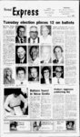
| OCR Text |
Show 8 Vernal Expre NOTICE OF TRUSTEES SALE The following described property will be sold at public auction to the highest bidder, payable in lawful money of the United States at the time of sale, at the front steps of the Uintah County Courthouse in Vernal, Utah on November 25, 1985 at 10:00 a.m. of said day for the purpose of foreclosing a Deed of executed Trust by Painted Hills Development Company, a partnership, as Trustor, in favor of American Savings & Loan Association, Trustee as Beneficiary, and covering real property located at Painted Hills Estates Uintah Subdivision, County, Utah, and more particularly described as follows: Property as described on original trust deed dated January 1983. Legal Description Lots 4,22,24, 27, 30, 44, 45, 46, 47, 53, and 55 of Phase PAINTED I, HILLS ESTATES SUBDIVISION, PLAT A, according to the official plat thereof on file in the office of the recorder, Uintah County Utah. Lots 48, 49, 50, 51, 57, 58, 59, 60, 61, 63, 64, 65, 67, 68, and 69 thru 103, Phase PAINTED HILLS ESTATES SUBDIVISION, PLAT A, according to the official plat thereof on file in the office of the recorder, Uintah County, Utah. Lots 1 thru 88 of the HILLS PAINTED ESTATES SUBDIVISION, PLAT B, according to the official plat thereof on file in the office of the recorder, Uintah County, Utah. I TOWNSHIP 4 SOUTH, RANGE 20 EAST, SALT LAKE MERIDIAN. Section 127 The1 Nor-- ' theast quarter of the' Northeast quarter; the South half of the Northeast quarter; the East half of the Southeast quarter of the Northwest quarter; the East half of the Northeast quarter of the Southwest quarter; the Southeast quarter of the Southwest quarter; the Southeast quarter. EXCEPTING THEREFROM: Beginning at a point 978.58 feet North 00302 West and 281.10 feet North 7010 West from the Southeast corner of Section 12, Township 4 South, Range 20 East, Salt Lake Base & Meridian; thence North 7010 West 219.31 feet; thence Nor- thwesterly 507.55 feet along the arc of a curve to the right having a central angle of 3010 and a radius of 964.00 feet; thence North 4000 West 29.46 feet; thence Northeasterly 183.44 feet along the arc of a curve to the left having a central angle of 454147 and a radius of 230.00 feet ; thence North 260.91 feet; thence East 620.91 feet; thence South 00302 East 594.50 feet; thence Southeasterly 128.41 feet along the arc of curve to the right having a central angle of 195302 and a radius of 370.00 feet; thence South 1950 West 94.92 feet to the point of beginning. ALSO EXCEPTING THEREFROM: Beginning at a point on the South line of said Section 12, Township 4 South, Range 20 East, Salt Lake Base & Meridian, which point bears North 894046 West 1792.46 feet from the Southeast corner of said Section 12; thence North 265652 East 250.65 feet; thence South 63"0308 feet; East 180.00 thence South 265652 West 160.41 feet to the South line of said Section 12; thence along said Section line North 894046 West 201.35 feet to the point of beginning. ALSO EXCEPTING THEREFROM: Lots 1, 2, 3, 5, 6, 7, 8, 9, 10,11,12, 13, 14, 15, 16, 17, 18, 19,20, 21,23, 26, 29,31,32,34, 35, 36,37, 38,39,40,41,42, 43, 52, 56, 62, PAINTED ESTATES of the HILLS SUBDIVI 66, SION, PLAT A, according to the official plat thereof on file in the office of the recorder, Uintah County, Utah. Total acreage of the above: 337 acres. Pro- perty located in the County of Duchesne. Parcel no. 1: Beginn- NOTICE OF S SALE NOTICE OF TRUSTEES SALE The following describThe following describThe following described property will be sold ed property will be sold ed property will be sold at public auction to the at public auction to the at public auction to the highest bidder, payable highest bidder, payable highest bidder, payable in lawful money of the' in lawful money of the in lawful money of the United States at the time United States at the time United States at the time of sale, at the front steps of sale, at the front steps of sale, at the front steps of the Uintah County of the Uintah County of the Uintah County Courthouse in Vernal, Courthouse in Vernal, Courthouse in Vernal, Utah on November 25, Utah on November 25, Utah on November 25, 1985 at 10:00 a.m. of said 1985 at 10:00 a.m. of said 1985 at 10:00 a.m. of said day for the purpose of day for the purpose of day for the purpose of foreclosing a Deed of foreclosing a Deed of foreclosing a Deed of Trust executed by Trust executed by Van S. Trust executed by John Charles D. West and Palmer and Pamela R. Dickey and Marjorie Hazel L. West, husband Palmer, as Trustors, in Cherie Dickey, husband and wife, as Trustors, the favor of American Savand wife, as Trustors, tiobligations of said Deed ings & Loan Association, tle to the subject properand Trustee of Trust having been as ty being transferred to assumed by Bob D. Beneficiary, covering Gerald J. Clark and Lula Schwalk and Judy L. real property located at P. Clark through a WarShwalk in a Consent to .638 West 250 South, Verranty Deed recorded Ju- Sale and Assumption nal, Utah, and more parly 28, 1981, in favor of Agreement recorded ticularly described as American Savings & December 6, 1982, in follows: Loan Association, as favor of American SavLot 1 of the Meadow Trustee and Beneficiary, ings & Loan Association, Park Subdivision, Vernal covering real property as and Trustee Utah, according to located at 9650 East 6000 Beneficiary, covering City,Official the Plat thereof South, Jensen, Utah, and real property located at on file in the office of the more particularly 1500 North 350 West, Ver- Recorder, Uintah Coundescribed as follows: nal, Utah, and more par- ty, Utah. 5 South, ticularly described as Township DATED this 21st day Range 23 East, Salt Lake follows: of October, 1985. Base & Meridian Section Beginning at a point on American Savings & .21: Beginning at a point the Section line 747 feet Loan Association, on the Northwest quarter East of the Southwest Trustee which NOTICE OF TRUSTEES SALE Fridoy, November 1, 1985 Township 4 South, Range 20 & East, Salt Lake Base Meridian; thence North 7010 West-219.3- 1 thence Norfeet; thwesterly 507.55 feet along the arc of a curve to the right having a cenof SOTO and a radius of 964.00 feet; tral angle TRUSTEE thence North 4000 ing at a point 240.00 feet West-29.4- 6 feet; thence East of the Northeast 183.44 feet Northeasterly Block corner of 22, Plat along the arc of a curve extension, A, cenRoosevelt City Survey, to the left having a and running thence East tral angle of 45"4147 of 230.00 169.00 feet; thence South and a radius 260.91 400.00 feet; thence West feet; thence North 620.91 East thence feet; 320.00 feet; thence North thence South 50.00 feet; thence East feet; East 594.50 feet; 00302 160.00 feet; thence North 350.00 feet to the point of thence Southeasterly 128.41 feet along the arc beginning, being in Secof a curve to the right 2 tion 22, township South, a central angle of having 1 West, Uintah Range and a radius of 195302 Meriand Special Base 370.00 feet; thence South dian, unplatted 1950 West 94.92 feet to Roosevelt. the point of beginning. Southwest quarter Parcel no. 2: BeginnALSO EXCEPTING point is 1097.71 feet East 80.00 feet a at point ing and 535 feet South of the THEREFROM: BeginnEast of the Northeast West quarter corner said on the a at point ing Block of corner 22, Plat section (said point being South line of said Section extension, A, 485 South parallel to the 4 South, 12, Township Roosevelt City Survey, l16th from the South 20 Lake Salt thence East 160.00 feet; Range East, U.S. of & which Base boundary Meridian, thence South 350.00 feet; North Highway 40 right-of-wathence West 160.00 feet; point bears and running thence thence North 350.00 feet 89'4046 West 1792.46 to the to the point of beginning, feet from the Southeast North parallel 100 feet; line Section of l16th said corner 12; being in Section 22, thence parallel to the thence North 265652 Township 2 South, Range y U.S. Highway 40 250.65 thence East feet; 1 West, Uintah Special West South East 630308 boundary, Meridian. and Base 180.00 feet; thence South 217.8 feet, thence South TO DUE 265652 West 160.41 feet parallel to the 16th line RECONVEYANCES to the South line of said 100 feet; thence East OF AND Section 12; thence along parallel to the South LOTS THE FOLLOWsaid Section line North highway right-of-wa- y ING IS A CURRENT 5 feet boundary 217.8 feet to 894046 DESCRIPTION OF THE to the point of beginning. beginning. PROPERTY SECURED DATED this 21st day ALSO EXCEPTING BY THE JANUARY 1983 of October, 1985. Lots THEREFROM: 1, TRUST DEED. 2, 3, 5, 6, 7, 8, 9 10, 11, 12, American Savings & Lots, 4, 24,27,30, 44,45, 13, 14, 15, 16, 17, 18, 19, 20, Loan Association, 46, 47, and 55 of Phase I, 21,22, 23, 25, 26,28, 29, 31, Trustee HILLS PAINTED 32, 33, 34, 35, 36,37,38,39, ESTATES SUBDIVI40, 41, 42, 43, 48, 52, 53, 54, LORIN D. RONNOW SION PLAT A, according 56, 57, 62, 66 of the Attorney for Trustee to the official plat thereof PAINTED HILLS 77 West 200 South on file in the office of the ESTATES SUBDIVISalt Lake City, Utah recorder, Uintah County, SION, PLAT A, accor- 84101 Utah. Published in the Verding to the official plat thereof on file in the of- nal Express Nov. 1, 8 and EXCEPTING fice of the recorder, Uin- 15, 1985. ,,THEREFROM: A portion of Lot 27 of the tah County, Utah. HILLS PAINTED ALSO EXCEPTING ESTATES SUBDIVITHEREFROM: BeginnSION, PLAT A, accoring at the Southwest cording to the official plat ner of Lot 17, PAINTED thereof on file in the of- HILLS ESTATES PLAT fice of the recorder, A said point being 419.614 described as follows: feet West and 191.173 feet North from the Southeast at the Beginning Southwest corner of said corner of Section 12, Lot 27; thence North Township 4 South, Range 074600 East 108.04 feet 20 East, Salt Lake Base NOTICE OF TRUSTEES SALE along the West lot line of & Meridian; thence N East 107.185 said Lot 27 to the Nor- 142239 The following describthwest corner of said Lot feet; thence East 33.33 ed will be sold South feet; thence S 3000 West at property thence 27; auction to the public 821400 East 19.99 feet 119.89 feet to the point of highest bidder, payable along the North lot line of beginning. in lawful money of the South Lot thence said 27; DATED this 21st day United States at the time 074600 West 109.67 feet of October, 1985. of sale, at the front steps to the South line of said American of the Uintah County Savings & Lot 27; thence North Loan Association, Courthouse in Vernal, 20.06 feet Trustee 77,3435 West Utah on November 25, along the South lot line of 1985 at 10 : 00 a .m . of said said lot 27 to the point of LORIN D. RONNOW day for the purpose of beginning. Attorney for Trustee foreclosing a Deed of Trust executed by James Lots, 49, 50, 51, 58, 59, 77 West 200 South K. Montgomery and Lin60, 61, 63, 64, 65, 67, 68, Salt Lake City, Utah and 69 thru 102, Phase I 84101 da Montgomery and HILLS PAINTED Published in the Ver- Clayton Slaugh, as ESTATES SUBDIVInal Express Nov. 1, 8 and Trustors, in favor of American Savings & SION, PLAT A according 15, 1985. to the official plat thereof Loan Association, as on file in the office of the Trustee and Beneficiary, NOTICE OF recorder, Uintah County, covering real property ASSESSMENT Utah. located at 5500 South 2600 WHITEROCKS 103-B- , East, Vernal, Utah, and Lots 103-IRRIGATION more 103-103-particularly and 103-- of described as follows: the PAINTED HILLS COMPANY LAPOINT, UTAH ESTATES SUBDIVIBeginning at a point in Notice is hereby given Section 17, Township 5 SION, PLAT A, Amended, according to the of- that at a meeting of the South, Range 22 East, ficial plat thereof on file Board of Directors held Salt Lake Base & Meriin the office of the the 16th day of October dian, East parallel to the Quarter Secrecorder, Uintah County, 1985, an assessment of East-WeSection said tion line & M O and $5.00 Utah. $2.00 for North and 699.0 confeet reservoir new for Lots 1 thru 88 of the to East to a 00137 in addition parallel, struction, HILLS PAINTED SecWest said of line the office $15.00 expense, ESTATES SUBDIVIwas levied on the tion 200.0 feet from the SION, PLAT B, accorstock of the West quarter Comer said ding to the official plat outstanding on or Section; thence North payable company, thereof on file in the ofNovember before 20, 1985 0or37 East parallel to Uinof the fice recorder, t, said West Section line to the secretary at tah County, Utah. 200.0 feet; thence East Utah 84039. TOWNSHIP 4 SOUTH, to the said parallel Any stock upon which RANGE 20 EAST, SALT line Section quarter reassessment the may LAKE MERIDIAN. 100.00 feet; thence South main unpaid on the day parallel to Section 12: The Norabove fixed for payment 0"0137 West Section line West said of the theast quarter will be delinquent and Northeast quarter; the advertised for sale at 200.00 feet; thence West to said quarter South half of the Norpublic auction, and parallel theast quarter; the East unless payment is made Section line 100.00 feet to half of the Southeast before will be sold on the point of beginning. DATED this 21st day quarter of the Northwest 23rd day of December quarter; the East half of 1985 to pay the delinquent of October, 1985. the Northeast quarter of assessment, together American Savings & the Southwest quarter; with the cost of advertis- Loan Association, the Southeast quarter of ing and expense of sale. Trustee the Southwest quarter; By order of the Board LORIN D. RONNOW the Southeast quarter. of Directors. Attorney for Trustee EXCEPTING A. DELORES 77 West 200 South THEREFROM: BeginnRUSHTON, Salt Lake City, Utah feet 978.58 a at point ing 84101 Secretary North 00302 West and Published in the VerPublished in the Ver281.10 feet North 7010 West from the Southeast nal Express Oct. 25, Nov. nal Express Nov. 1, 8 and corner of Section 12, 1, 8 and 15, 1985.. 15, 1985. right-of-wa- West-201.3- - E st .1 . corner of Section 11, Township 4 South, Range 21 East, S.L.M. and running thence North 148 feet; thence East 147.5 feet; thence South 148 feet; thence West 147.5 feet to the place of beginning. DATED this 21st day of October, 1985. American Savings & Loan Association, Trustee LORIN D. RONNOW Attorney for Trustee 77 West 200 South Salt Lake City, Utah 84101 Published in the Vernal Express Nov. 1, 8 and 15, 1985. NOTICE OF TRUSTEES SALE The following described property will be sold at public auction to the highest bidder, payable in lawful money of the United States at the time of the sale, at the South main entrance, Uintah County Courthouse, Vernal, Utah, on November 20, 1985, at 10:00 a.m. of said day, for the purpose of foreclosing that certain Trust Deed executed by KIRT W. MONTAGUE and SINDY S. MONTAGUE, his wife, as Trustors, to TOWN AND COUNTRY TITLE, INC., in favor of CITY FEDERAL SAVINGS AND LOAN ASSOCIATION, covering real pro- perty located at 4373 South 2500 East, Vernal, Utah, and more par- ticularly described as: Beginning at a point on the West line Section 8, T5S, R22E, SLB & M feet North of the Southwest comer of said Section; thence North along the said West Sec0 tion feet; thence East parallel to the South line said Section 193.0 feet; thence South parallel to said West Section line 100.00 feet; thence West parallel to the South Secfeet to the tion point of beginning. DATED this 18th day of October, 1985. 599.0 line-100.- LORIN D. RONNOW Attorney for Trustee 77 West 200 South Salt Lake City, Utah 15, 1985. NOTICE OF TRUSTEES SALE The following described property will be sold at public auction to the highest bidder, payable in lawful money of the United States at the time of sale, at the front steps of the Uintah County Courthouse in Vernal, Utah on November 25, 1985 at 10:00 a.m. of said day for the purpose of foreclosing a Deed of Trust executed by Monty R. Lee and Lana Lee, husband and wife, as Trustors, title to the sub- ject property being transferred to Jerry D. Carter and Patsy A. Carter through a Quit Claim Deed recorded December 14, 1983, in favor of American Savings & Loan Association, and Trustee as Beneficiary, covering real property located at Ca- nyon, Vernal, Utah, and more particularly described as follows: Commencing at a point located South 639.13 feet and East 250.00 feet from the West Vi comer of Section 15, T3S, R20E, SLB&M; thence north 322.08 feet; thence S 66 degrees 30 minutes 04 seconds East 163.57 feet; thence South 322.08 feet; thence N 66 degrees 30 minutes 04 seconds West 163.57 feet to the point of beginning. Subject to a 30 y foot along the West line of lot. DATED this 21st day of October, 1985. American Savings & Loan Association, Trustee SCOTT LUNDBERG Successor Trustee Published in the Vernal Express Oct. 25, Nov. 1 and 8, 1985. NOTICE OF BOUNDARY COMMISSION MEETING Notice is hereby given that the Uintah County Boundary Commission will hold a hearing on the application filed by the Ashley Valley Water and Sewer Improvement District protesting the proposed Gibson-Hatc- h and Ashley Creek annexations by Vernal City. The hearing will be held on Tuesday, December 3, 1985 at 7 p.m. in the District Courtroom in the Uintah County Courthouse in Vernal, Utah. A full copy of the application is on file at the office of the Uintah County Boundary Commission, Rm. 103, Uintah County Courthouse, Vernal, Utah. DATED this 1st day of November 1985. ROB HUGIE Commission Secretary Published in the Vernal Express Nov. 1, 6, 8 and 13, 1985. Theres a show for those who look back fondly on the more '60s as well. "Hometown" (CBS, Tuesday, which got a jump on its competition by premiering is about a in August group of college friends from the '60s and their adjustments (or lack thereof) to the very different '80s. directors seem ready to move over to the small screen. Steven Spielberg, has promHollyised that wood directors, including Martin Clint Eastwood, Scorsese, Brian de Palma and Spielberg himself, will be directing segments of his "Amazing Stories" an(NBC, Sunday, thology series. 8-- High-profi- big-na- Obituaries Mary DeJournette dies of cancer Searle Mary De- Siddoway Journette, 73, of Vernal died cancer at her home, Oct. 31, 1985. of She was born Feb. 16, 1912 in a daughter of Daniel Leo and La-poi- Annie Taylor Searle. married Ted Cloward, May 23, They were later divorced. She married William Wallace Siddoway in 1942. He died Jan. 9, 1962. She married Richard (Dick) DeJournette July 15, 1963 in Elko, Nev. She was a housewife, and in the sheep business with her second husband before his death. After she married her present husband, she helped him in his trapping business in Colorado. Survivors are her husband of Vernal; a son, Von Cloward of New Castle, Colo.; 12 grandchildren and four many great grandchildren; brothers, Jay Searle, Ira Searle, Lawrence Searle and Archie Searle all of Ogden; two sisters, Mrs. Leon Schulletter and Mrs. Afton both of Roy, Utah. She was preceded in death by her parents, a brother, Orrin Searle and a son, Ted Cloward, Jr. in Mary DeJournette In lieu of flowers, the family suggests contributions be made to the Cancer Society. Envelopes may be picked up at Thomsons Vernal Mor- tuary. Funeral services will be Sat. Nov. at 2 p.m. in the Vernal Mortuary Chapel. Friends may call on Friday from 7 p.m. to 9 p.m. at Thomsons Vernal Mortuary and Saturday one hour prior to the services. Burial will be at the Vernal Memorial Park under the direction of Thomsons Vernal Mortuary. 2, NOTICE TO NAPLES CITY VOTERS NOTICE IS HEREBY GIVEN that the following municipal ballot representing candidates for Mayor and City Council members will be presented to the voters November 5, 1985 at the polling place for Naples City residents. Said polling place for the municipal election for November 5, 1985 will be at the Naples Elementary School, 1971 South 1500 East. Polls will open at 7:00 a.m. and will close at 8:00 p.m. No person is entitled to vote in this municipality unless they have registered to vote. Any citizen of the United States who is a resident of the State of Utah and who will, by the date of this election, be 18 years of age and have been a resident of this state for a period of 30 days and is is entitled to vote in the November election. Any questions you may have regarding this election may be directed to the City Recorder at the Naples City Office, 1601 East 1900 South, 789-909- 0. Marlene Stidham, City Recorder Judges Initial Sample Ballot N right-of-wa- line-193.- 0 J. Whats COMING UP new this fall? Well, on the theory that the world loves a misfit, there's "Misfits of Science (NBC, Friday, In which a team of "weird losers" fights to make the world safe for the offbeat. The traditional family, which has taken a considerable pounding in recent years, may be poised for a comeback. In the wake of the success of "The Cosby Show, two new traditional families (complete with mother, father and chilROB HUGIE all living under the dren same roof) will be making Executive Secretary their television debuts in Uintah County (ABC, "Growing Pams Commission Boundary and Tuesday, 9.30-1VerPublished in the Charlie & Company Wednesday, nal Express Nov. 1, 1985. (CBS, She Published in the Vernal Express Nov. 1, 8 and Dryfork FAME 1927. 84101 12072 West PUBLIC NOTICE Notice is hereby given that the Uintah County Boundary Commission will hold a public meeting on Wednesday, November 13, 1985 at 7 p.m. in the conference room of the StateCoun-t- y Building. The purpose of the meeting will be to adopt bylaws and procedures under which the Uintah County Boundary Commission will conduct its hearings. LORIN D. RONNOW Attorney for Trustee South Salt Lake City, Utah 77 West 200 84101 Published in the nal Express Nov. and 15, 1985. Ver1, 8 NOTICE OF BOUNDARY COMMISSION MEETING Notice is hereby given that the Uintah County Boundary Commission will hold a hearing on the application filed by the Ashley Valley Water and Sewer Improvement District protesting the proposed Pike- - Countryside annexation by Vernal City. The hearing will be held on Thurs- day, November 21, 1985 at 7 p.m. in the Circuit Courtroom in the Uintah County Courthouse in Vernal, Utah. A full copy of the application is on file at the office of the Uintah County Boundary Commission, Rm. 103, Uintah County Courthouse, Vernal, Utah. DATED this 1st day of November 1985. ROB HUGIE Commission Secretary Published in the Vernal Express Nov. 1, 6, 8 and 13, 1985. Official Ballot For Naples City, Utah November 5, 1985 ) HTIqaIuuLj Recorder |