| OCR Text |
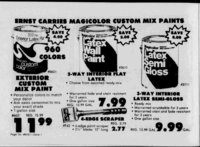
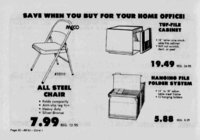
Show 1 WEEKLY NEWS JOURNAL, NORTH DAVIS LEADER, AUGUST 20, 1981 REFLEX-DA- VIS of part of Section WAIL !m , ?:- m REAL PROPERTY Civil No. 7451 to the official plat thereof. DATED August 6, 1981. SS0TTD(CIES MOUNT A1NWEST SAVINGS AND LOAN, Trustee NOTICE TO WATER USERS The following applications State Engineer to appropriate water in Davis County throughout have been filed with the the entire year unless otherwise designated. Locations in SLB&M. 50387(3 46X9) Glen L. Wilson. 967 W. .300 N.. Clinton. IT 0.05 sec. ft. of water is to he diverted from drain, at a point S. 30 ft. E. 330 ft. from NW Cor. Sec 26. T5N. R2W i('linton): and used from Apr. I to Oct. 31 for the irrigation of 0A acs. in NWWNW'i Sec. 26. T5N. R2W. Martin A. 56439 Ovordiek, Jr. At Darlene Ovoi -diek. 2827 E. 2550 N . , Layton, I I 0.045 sec. ft. of water is to weil he diverted from 200-70- 0 ft. deep, at a point S. V 'A 2s() It. E. 1477 ft. from Cor. Sec. 29. T5N. R2W (3 mi W.ot Sunset): and used for the domestic purposes of 1 family, stoekwatering 8 cattle: and horn Apr I to Oct. 31 for the rigation of 1.5 acs. in NF.'aSW', Sec. 29. T5N . ii R2W. Protests resisting the granti- ng of these applications with reasons therefore must be filed r, in duplicate with the State E.400S.,SLC,UT 231 1, on 841 or before Sept. 19. 1981. Dee C. Hansen. P.E. STATE ENGINEER Published in the Davis News Journal First publication Aug. 6, 1981 Last publication Aug. 20. 1981 Issue no. 27 The following applications State water Davis County throughout the entire year unless otherwise designated. Locations in SLB&M. Clinton ' ' Published in The Weekly Reflex First publication Aug. 13, 1981 Last publication Aug. 27, 1981 Issue No. 28 NOTICE OF PROPOSED BANK MERGER 7 1200 N. Church. No. 58. Layton. UT 0.0 15 sec. ft. of water is to be diverted from a spring, at a point S. 402 ft. E. 685 ft. from W 'A Cor. Sec. 10. T4N. RIW (2.5 mi N. of Lay ton): and used for stock-v- v a t e r i n g 10 in cattle NW'jSW'A Sec. 10. T4N. RIW. 56369 Joe Jensen. P.O. Box 73. Clearfield. UT 5.0 sec. ft. of water is to be well. diverted from a 100-60- 0 ft. deep, at a point N. 1320 ft. E. 20 ft. from S'A Cor. Sec . 22. T4N. R2W (2 mi S.of Syracuse): and used for stockwatering 50 cattle; and from Apr. I to Oct. 31 for the irriga- tion of 304.0 acs. in SE'A. SW4 Sec. 22. SE'A Sec. 21. T4N. R2W. Monan A. 56789 Lovell. 2198 W. 800 N.. Clinton. U T 0.05 sec ft. of water is to be diverted from a ft. deep, at a well. IN THE DISTRICT COURT OF DAVIS COUNTY, STATE OF UTAH UTAH DEPARTMENT OF TRANSPORTATION -- vs- LINDA F. EVANS TO BE SOLD AT A SHERIFF'S SALE on the 27th day of August, 1981, at the hour of 12:(JOO'c!ock p.m., at the north front door of the Davis County Courthouse in Farmington, Davis County, Utah, all the right, title and nonexempt interest of the defendant. Linda F. Evans, in and to the following described real property, to wit: Beginning at a point R2W. 56451 Mary Lou Niederhauser.983 W. 2300 N.. Clinton. UT0.03 sec. ft. of water is to be diverted from drains, at the following points: IS. 275 ft. W. 185 ft.: 2) S. 350 ft. W. 350 ft; both from NW Cor. Sec. 26. T5N.R2W (Clinton): and used from Apr. to Oct. 31 for the irrigation ofO. 33 acs. in NW'tNW'i Sec. 26. T5N. R2W. 56531 John P. Sorenson. 1169 N. 700 W.. Clinton, UT 0.015 sec. ft. of water is to be diverted from a ft. deep, at well, a point S. 725 ft. W. 1150 ft. from N'i Cor. Sec. 35. T5N. R2W (Clinton): and used from Apr. I to Oct. 31 for the irrigation of 0.25 acs. in NE'ANW'A Sec. 35, T5N. R2W. Protests resisting the granting of these applications with reasons therefore must he filed in duplicate with the State Engineer. 231 E. 400 S..SLC. UT 841 1, on or before Sept. 26. OF UTAH, NATIONAL BEGINNING 867.8 feet ASSOCIATION. Ogden, Utah and FIRST SECURITY STATE BANK OF OGDEN. Ogden. Utah and FIRST 1 SECURITY STATE BANK OF TWELFTH STREET, Ogden, Utah, and FIRST SECURITY BANK OF 1 OREM, NATIONAL ASSOCIATION, Orem, Utah, and FIRST SECURITY BANK OF RICHFIELD. NATIONAL ASSOCIATION, Rich- field. Utah, and FIRST SECURITY STATE BANK OF KAYSVILLE, Kaysville, Utah, and FIRST SECURITY STATE BANK OF HELPER, Helper, Utah, and FIRST SECURITY STATE BANK OF AMERICAN FORK, American Fork, Utah. The application was accepted for filing July 10, 1981. It is contemplated that all offices of the above-namebanks will continue to be operated. This notice is published pursuant to section 18(c) of the Federal Deposit Insurance Act and Part 5 of The Regulations of The Comptroller of the Currency (12 DFR 5). FIRST SECURITY BANK State Engineer Published in the Davis News Journal First publication Aug. 13. 1981 Last publication Aug. 27. 1981 Issue No. 28 OF UTAH, NATIONAL ASSOCIATION, Ogden, NOTICE OF TRUSTEES SALE The following-describe- d property will be sold at public auction to the highest bidder, payable in law ful money of the United States at the time of sale, at the North door of the Davis County Courthouse building in Farmington City, Davis County, State of Utah, on September8, 1981, at 11:30 a.m., of said day for the purpose of foreclosing the Trust Deed executed by J. D. Larson Construction Co., and Junior D. Larson and Karen H. Larson, husband and and wife, as trustors, in favor of Mountain-WeSavings and Loan, covering real property located at 1343 East Carrie Drive, Fruit Heights, Utah, and more particularly described as follows: All of Lot 12, CARRIE HEIGHTS SUBDIVISION, a subdivision st Utah FIRST SECURITY STATE BANK OF OGDEN, Ogden, Utah FIRST SECURITY STATE BANK OF TWELFTH STREET, Ogden, Utah FIRST SECURITY BANK OF OREM, NATIONAL ASSOCIATION, Orem, Utah FIRST SECURITY BANK OF RICHFIELD, NATIONAL ASSOCIATION, Richfield, Utah FIRST SECURITY STATE BANK OF AMERICAN FORK, American Fork, Utah FIRST SECURITY STATE BANK OF HELPER, Helper, Utah FIRST SECURITY STATE BANK OF KAYSVILLE, Kaysville, Utah PARCEL: BEGINNING at a point 975.5 feet North and 956.5 feet East from the Southwest corner of said Section 3, and running thence North 0 degrees 08 30 East 225.00 feet; thence South 89 degrees 51 34 East 270.00 feet; thence South 0 degrees 08 30 West 225.00 feet; thence North 89 degrees 31 30 West 270.00 feet to the point of BEGIN- North. 1 NING. PARCEL B A tract of land situate in the Southwest Quarter of Section 3, Township 4 North, Range West, Salt Lake Base and Meridian, being more particularly described as follows; BEGINNING at the Southeast corner of the Southwest Quarter of said Section 3, and running thence North 89 degrees 39 40" West 1335.58 feet along the section line; thence North 0 degrees 37 31 East 184.72 feet; thence Easterly along the arc of a 125.33 foot radius curve to the right 151.07 feet; thence North 69 degrees 41 12 East 1227.93 feet; thence Northerly along the arc of a 163.16 foot radius curve to the left 159.81 feet (LC bears North 41 degrees37 35 East 159.50) feet: to the Quarter Section line; thence South 0 dgrees 07 20 West 849.82 feet along the Quarter Section line to the point of BEGINNING. EXCEPTING FROM PAR- Utah 84041 PAYMENT TO BE MADE IN lawful money of the United States of America. SUBJECT TO any liens. DATED AT FARMING-TON- . DAVIS COUNTY. UTAH, this 3rd day of August. 1981. Published in the Davis News Journal First publication Aug. 6, 1981 Last publication Sept. 3, 1981 Issue No. 27 BRANT L. JOHNSON, Sheriff Davis County By Glenn S. Parker Deputy Sheriff Attorney: Stephen C. Ward; Assistant Attorney General 115 State Capitol Salt Lake City. Utah 84114 4 Telephone: Published in The Weekly Reflex part of the Southwest Quarter of Section 3, TownA ship 4 North, Range 1 West, Salt Lake Base and Meridian, U.S. Survey: BEGINNING at 1981 Issue No. 28 NOTICE TO CREDITORS Estate of Ann B. Wilcox, Deceased Probate No. 3003 The undersigned, having been appointed Personal Repabove-reference- d Estate on July 7, 1981, hereby give notice that quired to present them to the undersigned or to the Clerk of the Court on or before the 19th day of November, 1981, or said claims shall be forever barred. Buster Brown, school shoes. What could be better? Buster Brown shoes on sale just when the kids need them for You know the quality's right. And now the prices are remarkable. Stop back-to-schoo- l. in and save. R-1- LEGAL NOTICE First Security Bank of Orem, National Orem, Utah First Security field. National Richfield, Utah First Security point , shall be ratified and confirmed, subject to the approval of the Comptroller of the Currency, Washington, D. C., and for the purpose of voting upon any other matters incidental to the proposed merger of the banks. A copy of the aforesaid agreement, executed by a majority of the directors of each of the banks, providing for the merger, is on file at each bank and may be inspected during business hours. Frank V. Leifson, Cashier First Security Bank of Orem, N.A. Bank of Rich- Association, State Bank of American Fork, American David J. Simonsen, Cashier First Security Bank of Richfield. N.A. Fork, Utah First Security State Bank of Helper, Helper, Utah First Security State Bank of Kaysville, Kaysville. Utah First Security State Bank of Ogden, Ogden, Utah First Security State Bank of Twelfth Street, Ogden, Utah First Security Bank of Utah, National Association, Ogden, Utah SHAREHOLDERS MEETINGS Notice is hereby given that, pursuant to call of the Boards of Directors of the respective banks, a special meeting of the shareholders of each of the following banks. First Security Bank of Orem, National Association; First Security Bank of Richfield, National Association; First Security State Bank of American Fork; First Security State Bank of Helper; First Security State Bank of Kaysville; First Security State County, State of Utah, on September 17, 1980 as Entry No. 574428 in Book 839 at Page 838 given to secure a Promissory Note of even date in favor of J. MIKE ADAMS. A Notice of Default in the terms of said Trust Deed was recorded on April 29, 1981 as Entry No. 591268 in Book 865 at Page 713 and on May 5, 1981 as Entry No. 592535 in Book 867 at Page 594 of the Official Records of the Scott M. Eastwood. Cashier First Security State Bank of American Fork John Calvin Balch. Cashier First Security State Bank of Helper Richard B. Waite, Cashier First Security State Bank of Kaysville Judy Owens, Cashier First Security State Bank of Ogden Scott C. Russell. Cashier First Security State Bank of Twelfth Street P. Robert Benzley, Cashier First Security Bank of Utah, N.A. Published in the Davis News Journal First publication Aug. 20, 1981 Last publication Sept. 10. 198 Issue No. 29 "A little bit of Son Francisco con Jjvy" be found at the bedutiful Bratten's Cove in Bountiful" d if xf Sf j SUPERB SEAKXX) & STEAKS FAST, COURTEOUS SERVICE Mon. thru Thurs. 11 Soafood 1385 $. 500 Wwt Fri. and Sat A.M.- - 10P.M., Closed Sundays ' 11 Bountiful Phono 295-238- 4 You wont find a chicken sandwich like this at a burger place. Its something brand-nefrom Kentucky Fried Chicken. The Colonel uses a real breast filet In his chicken sandwich, all white meat. Nothing chopped, rolled or processed. And Its cooked with the Colonels secret blend of 1 1 herbs and spices, the same secret that makes our fried chicken the nation's favorite. So come on In to the Colonel's. Youll love It. Kentucky Fried Chicken. We do chicken right. 1 1 Published in the Davis County Clipper First publication Aug. 19, 1981 Last publication Sept. 2. 1981 Issue No. 32 Published in The Weekly Association, whether an agreement to merge each of the other banks into First Security Bank of Utah, National Association, located in Ogden, State of Utah, under the provisions of the laws of the United States, love, love, love youll our new chicken sandwich. Rosanne Birch Personal Representative SCHOOL First publication Aug. 20, 1981 Last publication Sept. 3, 1981 Issue No. 29 Bank of Ogden; First Security State Bank of Twelfth Street and First Security Bank of Utah, National Association will be held at 79 South Main Street, in the City of Salt Lake, State of Utah, on Mpnday, September 21, 1981 at 3:00 p.m. for the purpose of considering and determining by vote If you love our fried chicken, all persons having claims against the above estate are re- Jane F. Harrison Law Office of Moyle & Draper 600 Deseret Plaza No. 15 East 1st South Salt Lake City, Utah 841 0 Telephone (801) a which is North 89 degrees 39 40 West 590.00 feet along the Section line from the Southeast corner of said Southwest Quarter Section, and running thence North 89 degrees 39 Re- flex and J. MIKE ADAMS is named as Beneficiary, recorded in the office of the County Recorder of Davis PROPERTY: First publication Aug. 13, 1981 Last publication Aug. 27, Published in The Weekly INSURANCE AGENCY OF UTAH is named as Trustee, THE FOLLOWING DESCRIBED FLOYD S. WILCOX Personal Represeniative BACK TO SURANCE AGENCY OF UTAH, INC., TRUSTEE, is named as Trustor, and TITLE CELS A AND B 533-668- part of the Southwest -- 1 AKA: 2369 North Fort Layne. Layton. resentatives of the A Quarter of Section 3, Township 4 North, Range 1 West, Salt Lake Base and Meridian, U.S. Survey: BEGINNING at a point which is South 89 degrees 39 40 East 882.00 feet along the section line from the Southwest corner of said Section 3 and running thence North 7 degrees 56 28 West 102.67 feet; thence East 242.00 feet, thence North 340.00 feet, thence East 214.26 feet; thence Easterly along the arc of a 71.83 foot radius curve to the right 87.36 feet (LC bears South 55 degrees 09 24 East 82.07 feet); thence South 20 degrees 18 48 East 37.06 feet; thence North 69 degrees 41 12 East 975.00 feet; thence South 20 degrees 18 48 East 66.00 feet; thence South 69 degrees West 975 feet, thence Southerly along the arc of a 125.33 foot radius curve to the left 151.07 feet, (South 35 degrees 09 22 West 142.09 feet); thence South 0 degrees 37 31 West 142.09 feet to the Section line; thence North 89 degrees 39' 40 West 461.39 feet along the section line to the point of BEGINNING. The street address of the above described property is not available. Said sale will be conducted by WESTERN TITLE COMPANY, Successor Trustee, pursuant to the terms of that certain Trust Deed dated July 30, 1980 wherein TITLE IN- ALSO EXCEPTING THEREFROM THE FOLLOWING DESCRIBED d P.E. PROPERTY: GINNING. Range West. Salt Lake Meridian, thence South 89 degrees 08' West 140 feet: thence North 0 degrees 52 West 15 feet: thence South 89 degrees 08' West 160 feet: thence North 0 degrees 52 West 95 feet: thence South 89 degrees 08' East 300 feet to the West line of said street; thence South 0 degrees 52' East 101.07 feet to the point of beginning. WESTERN STATES TITLE COMPANY, Successor Trustee By: Jeffrey J. Jensen, Vice President THE FOLLOWING DESCRIBED 340.00 feet; thence West 242.00 feet to the point of BE- 1378.40 feet East and North degree 28 West 1032.4 feet and East 1109.4 feet and North 0 degrees 52 West 773.11 feet from the Southwest corner of Section 9. Davis County Recorder. The Trustee will sell said real property at public auction, without warranty, to the highest bidder for cash, payable in lawful money of the United States of America at the time of sale. A copy of this Notice was published in The Weekly Reflex on August 19, 1981, Au1981 an 27, gust September 3, 1981. Dated: August 17,1981 CELS A AND B East and 96.47 feet North from the Southwest corner of said Section 3, and running thence North 340.00 feet; thence East 242.00 feet; thence South North Fort Lane. 4 1 ROM THE FOLLOWING on the West line of Township West 745.48 feet along the Section line; thence North 0 degrees 37 31 East 184.86 feet; thence Easterly along the arc of a 125.33 foot radius curve to the right 151.07 feet (LC bears North 35 degrees 09 22 East 142.09 feet); thence North 69 degrees 41 12 East 1066.00 feet thence South 20 degrees 18 48 East 115.00 feet; thence South 69 degrees 41 12 West 400.25 feet; thence South 0 degrees 20 20 West 428.56 feet to the point of BEGINNING. EXCEPTING FROM PAR- 40 DESCRIBED PARCEL: 1 Notice is hereby given that application has been made to the Comptroller of the Currency, Washington, D. C. 20219 for his consent to a merger of FIRST SECURITY BANK A. Jacobsen. 100-60- 0 1 DEE C. HANSEN, have been filed with the Engineer to appropriate 56364 By Thatcher, Glasmann Davis 1000 First Security Bank Bldg., Ogden, UT 84401 Attorneys for Trustee and Beneficiary & 1981. NOTICE TO WATER USERS in point N. 350 ft. W. 950 ft. from SE Cor. Sec. 33. T5N. R2W (Clinton); and used for the domestic purposes of I family, stockwatering 25 rabbits, 20 chickens; and from Apr. to Oct. 31 for the irrigation of 0.5 Sec. 33. acs. in S E S E T5N. R2W. 56450 Bryan S. Wayment. 987 W 2300 N.. Clinton. UT 0.05 sec. ft. of water is to be diverted from drains, at the follow ing points: l)S. 30 ft. E. 145 ft.: 2) S. 275 ft. W. 185 ft.: 3) S. 350 ft. W. 350 ft.: all from NW Cor. Sec. 26. T5N. R2W (Clinton): and used from Apr. I to Oct. 3 for the irrigation of 0.66 acs. in NW'ANW'A Sec. 26. T5N. 1 ON Fruit Heights, according 4 Westerly along the arc of a 163.16 foot radius curve to the right 59.8 ffeet (LC bears So. 41 degrees 37 35 West 153.50 feet); thence South 69 degrees 41 12 West 1227.93 feet; thence Southerly along the arc of a 125.33 foot radius curve to the left 151.07 feet thence South 0 degrees 37 31 West 184.72 feet to the Section line; thence South 89 degrees 39 40 West 1343.40 feet to the point of BEGINNING. EXCEPTING THEREF- NOTICE OF SHERIFFS SALE 37, Township 4 North, Range 1 West, Salt Lake Meridian, in the City of JKewWfa, fheri Re- flex First publication Aug. 20, Last publication Sept. 3. Issue No. 29 1981 1981 NOTICE OF TRUSTEES SALE The following described real property will be sold at public auction to the highest bidder at the North steps of the Davis County Courthouse in Farmington, Davis County, State of Utah, on September 15, 1981 at 10:30 o'clock A.M. of said day: See Exhibit A attached hereto and by this reference made a part hereof. EXHIBIT A PARCEL A A tract of land situate in the Southwest Quarter of Section 3. Township 4 North. Range West, Salt Lake Base and Meridian, being more particularly described as follows: BEGINNING at the Southwest corner of said Section 3, and running thence North 0 degrees 08 30 East 1319.51 feet along the Section line; thence South 89 degrees 43 12 East 2678.52 feet along the North line of the South half of the Southwest Quarter of said Section to the Quarter Section lin-thence South 0 degrees 07 20 West 466.45 feet along the Quarter Section line; thence 1 s 89 DIG 15-PIEC- DUCKET CHICKEN BREAST FILET SANDWICH ' '' v rnmm " jmi ft ONLY GeM5 pieces of the Colonel s Original Recipe or Extra Crispy, of gravy and 5 rolls for only $7 39 Limit one coupon per Get our new chicken sandwich lor only $1 39 Limit 2 orders per coupon Customer pays all applicable sales tax customer Customer pays all applicable sales tax OFFER EXPIRES SEPTEMBER 28, 1981 (This coupon good only at alore addresses listed m this ad) COUPONS GOOD E AT STORES LISTED (inis coupon goooomyai store addresses listed m this ad) mm OFFER EXPIRES SEPTEMBER 28, 1381 u ms coupon gooo only at store addresses listed m this ad) BELOW: Bountiful: 498 South Main. North Salt Lake: 1015 North 500 East. Clearfield: 225 North Main Street, Roy: 1864 West 5300 South. Layton: 734 South Main. M . |