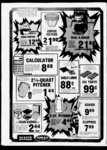
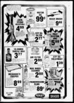
| OCR Text |
Show WEEKLY family in NW 'ASW'i Sec 10, T3N, R1W, SLB&W Protests resisting the granting of this application with reasons therefore must be filed m duplicate with the State Engineer, 231 E 400 S , SLC, UT 84111, on or before June 27, 1981 P.E. State Engineer DEE C. HANSEN, NOTICE OF HEARING CAISE NO. 190-- BEFORF NOTICE OF FILING OF TRANSFER OF CLASS D ALLOTMENT BY WEBER BASIN 3 THE BOARD OF OIL, GAS AND MINING DEPARTMENT OF OWNERS. AND OTHER PERSONS IN THE STATE OFLTAH INTERESTED IN DRILLING FOR AND THE PRODLCTION OF OIL AN DOR GAS Under the provisions of Chapter 6, Title 40 Utah Code Annotated. 1953. the Board of Oil, Gas and Mining held a hearing on Thursday, March 26 iyKl . in the Wildlife ReA96 sources Auditorium West North Temple Salt Lake City Utah for the purpose of receiving comments, changes and amendments to the General Rules and Regulations in addition to several amend ments proposed by the Divi sion Having considered the com- ments and amendments presented at said hearing, the Board is now prepared to final ie for adoption rules covering the billowing Rule to curtail the flaring of gas 2 Rule l 1(b) to require the association of local counsel in matters before the Board 3 Housekeeping change to all current rules and regulations (Board andor Division in lieu of Commission) Therefore, notice is hereby given that the Board of Oil. Gas and Mining will conduct a hearing on Thursday, May 28, 1981, at 9 00 a m , in the Wild7 B-- life Resources Auditorium, 15 West North Temple, Salt Lake City, Utah, for the purpose of adopting said heretofore described rules 1981 STATE OF UTAH BOARD OF OIL, GAS AND MINING possession or encumbrances, at the north front door of the County Courthouse, Main and Section 36 Township 4 West. Salt North, Range Lake Base and Meridian, 1 State Streets, Farmington, Davis County, Utah A Copy of the petition for the transfer containing the description of lands to which such water has heretofore been allotted and the lands to which it is proposed the said water be transferred and the terms and conditions of which the transfer is petitioned for is on file in the office of the W eber Basin Wa- ter Conservancy District, t, acre-fee- The Board of Directors of the District will meet in public session at the office of the District at 9 30 a m , Friday, May 29, 1981, to consider said petition and any and all objections that may be presented in writ- showing cause why said petition for transfer should not be granted All persons interested may appear at such hearing and show cause in writing w hy said petition, or any thereof, should not be granted Failure of any person to show cause in writ-in- g as aforesaid, shall be deemed an assent on his part to the granting of said petition The Board will at such meeting. or at a subsequent meeting adjourned therefrom, accept or reject the petition ing by any person KEITH G. JENSEN, Secretary Weber Basin Water Conservancy District Published in the Davis News Journal First publication May 13, 1981 Last publication May 27, 1981 Issue No 15 . . NOTICE TO WATER USERS Secretary of the Board Division of Oil, Gas and Mining West North Temple Salt Lake City. Utah 84116 S88 1 Published in the Davis County Clipper on May IT, 1981 Issue No 17 6 Published in the Davis News Journal on May 13, 1981 Issue No 15 7 NATIONAL FLOOD INSLRANCE PROGRAM Proposed Hood Hevation Determinations AGENCY' Federal Insurance Administration. FEMA ACT ION Proposed Rule SUMMARY Technical information or comments are solicited on the proposed base ( 100 year) flood base Donald H Fraser, 389 S East Oaks Dr , Fruit Heights, UT has filed with the State Ento gineer Appl 561 18 appropriate 0 015 sec ft of water in Davis County The water is to be diverted from a 2 inchwell. deep, at a point S 250 ft E 50 ft from W' Cor Sec 10.T3N.R1W. SLB&M(2miS of Kaysville). and used from Jan I to Dec 31 for the domestic purposes of ft 1 elevations listed below for selected locations in the nation These base flood elevations are the basis for the flood plain management measures that the community is required to either adopt or (100-yea- show evidence of being already in effect in order to qualify or remain qualified for participation in the National (100-yea- flood elevations r) Utah, on the 26th day of May , 1981, at 10 00 o'clock a m of said day All of Lot 123, MAPLE HILLS SUBDIVISION No 2, PLAT "D , a subdivision of part of Section 33, Tow nship 2 North, Fast, Salt Lake Range Base and Meridian Commonly known as 2884 South Wood Hollow W'ay, Bountiful, Utah 84010 The Trust Deed being foreclosed by these Proceedings is dated August 23, 1979, and was executed by RAPHAEL MECHAM AND SHERI MECHAM, his wife, who are the present owners The purchase price is payable in lawful money of the U States Dated this 24th day of April, 1 Layton, Utah, for public inspection The name of the petitioners and the amount of wafor which the ter, in acre-feetransfer applies is as follows 2 0 t Norma A Ward Paula Frank The proposed The follow ing described real property will be sold at public auction to the highest bidder with out warranty as to title, in Copies of the amendments proposed may be obtained from the Division of Oil, Gas and Mining upon rquest DATED this 5th day of . 4 NOTICE QF TRLSTEES SALE interested will please lake notice that there has been filed with the Board of Directors of the Weber Basin Water Conservancy District, a petition applying for the transfer of an allotment ot W eber Basin water from lands All persons THE STATE OFLTAH TO ALL OPERATORS TAK ERS OF PRODLCTION. MINFRAL AND ROYALTY (801) 1981 1981 DISTRICT RAL RFSOl RtES in and for the STATE OF ITAH Phone Re- flex W ATER CONSERN ANCY NTl May, Published in The Weekly First publication May 13, Last publication May 27, Issue No 15 i 181 MAY 13, NEWS JOURNAL, NORTH DAVIS LEADER, REFLEX-DA- VIS Faerber and Gloria R Faerber, his wife, jointly and to the survivor, by reason of the breach of certain obligations secured thereby Notice of Default was recorded January 30, 1981 as Entry No. 584980 in Book 856 at page 30 of said Official Records. Trustee will sell at public auction to the highest bidder for cash, payable m lawful money of the United States at the time of sale, without warranty as to title, possession or encumbrances, the following described property in the City of Layton, County of Davis, State of Utah NOTICE OF HEARING I PON THE REALLOCATION OF ALLOTMENTS OF WATER AND OF ITS ACCOMPANING TAX LIENS BY WEBER BASIN WATER CONSERN ANCY DISTRICT To all owners and licnhol ders interested in any portion of lands in Sections 4. 8, 9 II, 14, 23, 24, 25, 27. & 36, Town- ship 4 North, Range I West, Salt Lake Base and Meridian (North Davis area), and Sections 23. 24. 25 & 26, Township 3 North. Range I West. Salt Lake Base & Meridian (West North, Range the Westerly line of a Highway; thence South 42 degrees 32 10" East 55.08 feet along the Westerly line of said Highway; thence South 58 corner of the motel 236 82 feet; thence North 31 degrees 0930 West 54 0 feet to the point of beginning TOGETHER WITH AND SUBJECT TO a Beginning at a point North 255 18 feet and East 794 77 feet from the Southwest corner of Section 21, Township 4 1 West, Salt Lake Meridian, said point being also South 58 degrees 5030" W'est 15 feet and North 31 degrees 0930 West 2 0 feet from the Northwest building, and running thence North 58 degrees 5030 East 225 95 feet along a line parallel to the Northerly line of said motel building to Farmington area) The Board of Directors of Weber Basin Water Conservancy District has heretofore made, entered and recorded its orders alloting amounts of Class D water in DAVIS County, Utah upon petitions which include but are not limited to the original petitions hereinafter described Since the entry of orders making the allotments of water, the tracts of land to which the allotments were made have been divided or d into small tracts, and the ownership of some or all thereof have degrees 5030" West 1 nghtofwayover Beginning at a point North 255 18 feet and East 794 77 feet and North 58 degrees 5030 10 0 west corner of said Section 21, which point is also South 58 degrees 50 30 W'est 5 0 feet and North 31 degrees 0930 West 2 0 feet from the Northwest corner of a motel building, and run31 dening thence South grees 0930 East 31 43 feet, thence South 60 degrees 1640 W est 19 8 feet, more or less, to the East line of Main Street, thence North 32 degrees 19 West 10 0 feet along said street line; thence North 60 degrees 1640" East 110 0 feet, more or less, along a line 0 5 of a foot Southerly from the Southerly line of a building, thence North 31 degrees 0930 West 21 4 feet, thence North East 58 degrees 5030 10 0 feet to the point of beginning TOGETHER WITH A RIGHT OF WAY for ingress and egress on a strip of land 20 0 feet wide running from the South line of said property, Southerly across the adjoining land and continuing Southerly on the existing right of way to Gentile Street for the purpose of paying obligations secured by said Deed East feet from the South- - each of the allotments of w ater hereinabove specified be reallocated to the several tracts into w hich each larger tract has been divided or subdivided substantially proportionately to the area size of each smaller tract to the larger tract The names of the original petitioners, the amount of water allotted under the original petitions, the names of the ow ners as of January 1, 1981, of the smaller tracts into which the dilarger tracts have been of water amount the and vided, reallocated to each smaller tract is as follows changed, and it is in the best interest of the District that of Trust including fees, Reallocations charges and expenses of Trustee, advances, if any, under the terms of said Deed, interest thereon and the unpaid principal of the Note secured by said Deed of Trust with interest thereon as in said Note and by law provided Dated May 5, 1981 (North) SECURITY TITLE COMPANY Trustee By Gordon Gurr Its Owner and 1981 Sole Proprietor PAUL M. HALI.IDAY Successor Trustee Published m The Weekly 455 East 400 South No 400 Salt Lake City, Utah 841 Telephone First publication May 13, 1981 Last publication May 27, 1981 ..R-10- 6 Issue No 15 . 6 Pubbshed in the Davis News Journal First. publication April 29. 1981 Last publication May 13, 1981 Issue No 13 . State (100-yea- The following described property will be sold at public auction to the highest bidder on the 9th day of June, 1981 at 00 A M at the North front door of the Davis County Court House at Farmington, Utah in the County of Davis, by SECURITY TITLE COMPANY, as Trustee under the Deed of Trust made by American Capital Corp , D Kim Rogers (President) & Sharon M Rogers, (Sec ) as Trustors, and recorded August , 980 as Entry No 570417 in Book 833 at pages 342 of the Official Records of Davis County, Utah, given to secure an indebtedness in favor of FIRST Published in the Davis County Clipper First publication May 6, 1981 Last publication May 13, 1981 Issue No 15 1 1 NOTICE OF SALE The following described property will be sold at public auction to the highest bidder on the 9th day of June, 1981 at 11 00 A M at 11 00 A M at the North front door of the Davis County Court House at Farmington, Utah in the County of Davis, by SECURITY TITLE COMPANY, as Trustee under the Deed of Trust made by Danny Clair Briden-stin- e & B & E Investment Co , a partnership, as Trustors, and recorded July 26, 1979 as Entry No 539267 in Book 781 at pages 997 of the Official Records of Davis County, Utah, given to secure an indebtedness in favor of David M Faer-be- r and Fred R Faerber, (now owned and held by Fred R 1 SECURITY BANK OF UTAH, NATIONAL ASSOCIATION (now owned and held by First Security Bank of Utah, N A ) by reason of the breach of certain obligations secured thereby Notice ot Default was re corded February 3, 1981 as Entry No 585359 in Book 856 at page 623 of said Official Records Trustee will sell at public auction to the highest bidder for cash, payable in lawful money of the United States at the time of sale, without warranty as to title, possession or encumbrances, the following described property in the City Flood Insurance Program (NF1P) DATES The period for comment w ill be ninety (90) days following the second publication of this proposed rule in a newspaper of local circulation in each community ADDRESSES See table below of Farmington, County of Davis, State of Utah, Navy Signalman 2nd Class Chris A Pamsh. son of Joel R and Jeannine P Parrish of Depth in feet above CityTownCounty Source of Flooding Location ground. Elevation In feet Kaysville, recently visited Pattaya Beach, Thailand He is a crewmember aboard the frigate USS Ouellet, homeported m Pearl Harbor, Hawaii (NGVD) THE FOLR-daport visit came after 71 continuous days at sea as a member of the USS Ranger Carrier Group in the Indian Ocean The ship is currently deployed to the Western Pacific as a unit of the U S 7th Fleet, and has made other port y Send consents rumk odnie Mr Robert G Chappell. National Flood Insurance (202) 755 Ssgs Program eral Emergency pe(j Management DC Agency. Washington 20T2 SUPPLEMENTARY IN FORMATION The Federal Insurance Administrator gives notice of the proposed determinations of base I (X) year) flood elevations for selected locations in the nation in accordance with section Oof the Flood Disaster Protection Act of 1973 (Pub I 93 234) 87 Stat 980 which added seetion 1363 to ( the National Flood Insurance Act of 1968 (Title XIII of the Housing and Urban Development Act of 1968 (Pub L 42 U S C and 44 CFR 67 4 (a) These elevations, together with the flood plain management measures required by Section 60 3 of the program regulations, are the minimum that are required They should not be construed to mean the community must change anv existing ordinances that are more stringent in their flood plain management require ments The community may at anv time enact stricter requirements on its own. or pursuant to policies established by other 4001-412- Federal. State, or Regional entities These proposed elevations will also be used to calculate the appropriate flood insurance premium rates for new buildings and their contents and for the second laver of insurance on existing buildings and their contents Published in the Davis County Clipper First publication May 13, 1981 Last publication May 20. 1981 Issue No 17 Published in The Weekly Re- flex First publication Mav 13. Last publication May 20. Issue No- - 15 1981 1981 8 West 428 40 feet, thence South 53 degrees 40 East 74 33 feet, thence South 31 degrees West 94 0 feet, South 87 degrees East 268 19 feet, South 2 degrees West 214 98 feet, 30 thence 3320" thence 2640" thence North 86 degrees 30 West 272 11 feet, thence Westerly 35 05 feet along the arc of a 168 0 foot radius curve to the right through a central angle of 57 1 1 degrees 207 40 degrees North 88 27 10" West 10, thence feet, thence 133 50 feet, thence North 7 degrees 10 West 135 77 feet, thence North 86 degrees East 23 15 feet, thence North 5 degrees W'est 146 41 feet, thence North 35 degrees 58 05" East 68 37 feet, thence North 2 degrees 5820" East 140 77 feet to the South line of said Quail Cove, thence North 80 North degrees 03 13 East 435 0 feet along the South line of said Quail Cove to the point of beginning for the purpose of paying obligations secured by said Deed of Trust including fees, 1 charges and expenses of Trustee, advances, if any, under the terms of said Deed . interest thereon and the unpaid principal of the Note secured by said Deed of Trust with interest thereon as in said Note and by law provided Dated May 5, 1981 TITLE COMPANY, Trustee By Gordon Gurr Its Owner and Sole Proprietor ( Published in the Davis County Clipper First publication May 13, 1981 Last publication May 27, 1981 Issue No 17 Published in The Weekly Reflex 1981 First publication May 13, Last publication May 27, Issue No. 15 1981 NOTICE TO CREDITORS hstate of Herbert J Barnes. Deceased Notice is hereby given that the undersigneds are duly appointed, authorized and action personal representatives of the above Estate All persons having claims against the above estate are required to present them to the undersigneds or the Clerk of the Court on or before the 6th day of August, 1981, or said claims shall be forever barred 1 I J. CANUTE BARNES, M.D. Barbara Gillespy Personal Representatives 144 South Fifth East Salt Lake City, Utah 84102 Published in The Weekly Re- flex First publication May 6. 1981 Issue No 14 Last publication May 20, 1981 7 Copies of the applications for reallocation as above set out containing the description of the land covered by the allotment under each original petition, and the description of the smaller tracts into which the larger have been divided and subdivided with proposed reallocations to each smaller tract are on file in the office of the Weber Basin Water Conservancy District at the intersection of Hill Field Road and Highway 89 in Davis County, Utah and mav be inspected by any interested person Notice is hereby given that at 9 30 a m on Friday , May 29. 1981. or at such subsequent time to which the hearing may be adjourned the Board of Directors of the W'eber Basin Water Conservancy District will meet in public session at the office of the District as aforesaid to consider the applications for reallocations and to consider making its orders reallocating the water and the liens covered thereby in accordance with the applications for reallocation or such other order or orders as it deems in the best interest of the District All persons interested are invited to attend such hearing and will be heard in support or opposition thereto KEITH G. JENSEN, Secretary W'eber Basin Water Conservancy District .... 9 long-rang- e Kelly Horne Kaysville Clubs specialist course at Chanute AFB, III Mrs Mary Timothy will entertain the Lakeview Circle Neighborhood Birthday Club at her home Monday afternoon. Mrs Rebecca Ashbaker was cohostess The Kays Creek Chapter League of Utah W'nters met Thursday evening at the Senior Citizen Center in Kaysville for their regular meeting with Mrs Carol Collett, president in charge Reports were given by Mrs. Collett who had attended the League of Utah W nters Workshops on April held in the South Jordan Library. The workshop was on poetry and 1 1 Published in the Davis News Journal First publication May 13, 1981 Last publication May 27. 1981 Issued No 15 calls in the Philippines, Diego Garcia, and the Maidive Islands The Ouellet is 438 feet long with a crew of 250 Equipped with guns, missiles and rockets, it can operate independently or as part of a naval task force The ship is also outfitted with a landing platform and normally carries a light heldetecicopter for tion and attack of submarines Airman Kelly B Horne, son of Air Force Col Edwin G Horne Jr of Layton, has graduated from the U S Air to the Honorable Ernest Eberhard, Davis County Courthouse, Farmington, FOR FURTHER INFORMATION CONTACT and running thence South 31 degrees 45 Chris Parrish Visits Thailand for selected locations Flood Elevations r) 1 SECURITY are: Proposed Base Cove, a PUD, at a point South 89 degrees 0550 W'est 636 53 feet along the section line and due South 650 58 feet from the Northeast comer of Section 13, Township 3 North, Range W'est, Salt Lake Meridian, in the City of Farmington, NOTICE OF TRLSTEES SALE 7 TRl STEES Re- flex Beginning on the South line of Quail Mrs Mary Timothy who attended the workshop on sonal history per- Force aircraft maintenance GRADUATES OF the course were trained in aircraft engine maintenance, repair and service, and earned credits toward an associate degree in applied science through the Community College of the Air Force Horne will now serve at Altus AFB, Okla k t Stephan Crites t Marine Pfc. Stephan M Crites, son of Robert E. and Roberta A Cntes of Layton, has been promoted to his present rank while serving at Marine Barracks, U S Facility, Subic Bay, Philippines i |