| OCR Text |
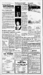
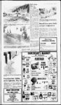
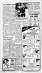
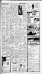
Show The Voice of Volume Ml. Ninety-tw- o PLEASANT, UTAH 84647 - May 16, 1984 Sanpete bounty Number Twenty Price 30 Raise US-8- 9 State plans to drain debris basin EPHRAIM Highway 89 through Thistle is expected to be high and dry after plans to raise the road bed and drain an additional five feet of water from the debris basin are implemented, according to Utah State officials who met with Sanpete mayors and commissioners May 10. Larry Lunnen, Utah Public Safety Commissioner, massive slide wiped out several homes in Clear Creek Saturday and and a Price man was killed when he was caught in the debris, About 43 homes are located in the community which is about ten miles A south of Scofield and about son. 25 miles east of Fairview. Photo: Jay Peter-Sunda- y Flood waters cause damage MT. PLEASANT It is becoming anything but a silent spring in Sanpete Valley and nearby areas as rivers begin to roll and mud slides are again causing damage to roads and highways. High winds Sunday night also caused some damage in the county. High gusty winds took the roof off a lambing shed belonging to Jay Peterson in Milbum. Several homes in Clear Creek, a Several people escaped, but Mr. small town 10 miles south of Scofield Koski apparently ran the opposite and about 25 miles east of Fairview direction into the knee deep mud were damaged. from another slide a day earlier and on Utah Highway was buried in the mud and debris. His body was recovered several The Sheriffs department said Mr. hours later. Koski was helping move valuables from the summer home of his d brother-in-law- , Two of the towns two dozen Richard Sutton, Salt residents have evacuated Lake City when the slide broke their homes. loose. year-roun- Crews wont use machinery start cleanup work for fear to of causing another slide. The slide areas is on the west slope of Clear Creek Canyon. It is an unstable area ahout 150 feet wide and 70 yards long. The slide started moving Saturday and wiped out several garages. Most of Clear Creeks 43 houses are summer homes. Highway 31 was closed Sunday after a large mud slide covered the road about 6 a.m. according to Ron Christensen of the Department of Transportation. The slide, located one half mile above White Pine was 150 feet wide and 20 feet deep and UDOT crews worked from 7 a m. Sunday until 10 a m. Monday to clear the snow, mud. rock and trees from the road. The rolling mud and debris blocked Cottonwood Creek until the water broke through. However, not enough water backed up to cause too much concern for flooding of Fairview which lies at the mouth of the canyon. The road was reopened off and on Sunday, but the slide kept coming and hampered the efforts of the workers to keep the road open. At one point a piece of equipment became stuck in the slide, but it was recovered. The weekend slide is about three or four miles above the large slide that closed the road last year. Another slide occurred Monday about noon in Huntington Canyon, but it' was a small slide and crews had it cleared up by 2 p.m., Christensen said. UDOT crews are working on U 31 24 hours a day to keep the road open, Christensen concluded. Utah Department of Transportation workers, Ron Christensen and Kevin Jensen attempt to pull this huge caterpiller out of the mud. The vehicle was caught in the muddy debris Sunday when a large slide came down on the Fairview Canyon Road, In Indianola Bud Bigler reported that Thistle Creek had risen as high as last year when it tore through farms lands and wiped out irrigation systems. Bigler reported two county bridges had been destroyed this year and he said he could not be certain how long water could be contained in the main channel. He said there is also concern that flood waters may destroy the valleys irrigation system and added that a major problem facing farmers in Indianola is being able to get to the areas to help prevent more damage. The raging creek is also threatening a bridge on Highway 89 near Birdseye. As the Sanpitch River collects water from its tributaries, farms along its bank are also beginning to flood. Waters are rising on areas south of Moroni again this year. However, Sanpete County Sheriff Kennard Anderson said Tuesday morning no other areas had reported any serious problems with flooding or run off. A Carbon County Sheriffs dispatcher reported that hydrologists who surveyed the area recommended draining the flood debris basin to keep Highway 89 open. Draining of the basin was sidered, Sturzenegger continued, discontinued late last year with 10 one in case the channel is not feet of the water and silt from lowered and one to use if the channel Thistle Lake remaining in the is lowered the proposed five feet. bottom. Movement, discovered in Two alignments the toe of the massive earthen slide Both alignments call for raising that created Thistle Lake, was at- the road bed. tributed to the blasting of the According to Sturzenegger, a drainage tunnel being used to lower curve is being designed into the the lake level and further drainage alignment where the old Thistle attempts were aborted to prevent Junction bridge is and the bridge any new slide activity, Lunnen will be replaced The grade above Thistle where the highway crosses explained. Now experts fear that debris or the railroad will also be realigned, rock could clog the inlet of the but changes are not expected to drainage tunnel that allows the increase the grade at that point Spanish Fork River to flow around above six percent. the massive slide. If the tunnel were South of Thistle Highway 89 will clogged, water would back up in the remain on the east of Thistle Creek flood basin and Highway 89 would be and the Rio Grande will keep their inundated once again. alignment west of the creek. Both Level lowered alignments are expected to be If the level of the basin is lowered raised, there as well. five feet, Lunnen indicated the Sturzenegger continued his Spanish Fork River could then cut comments by explaining that UDOT its own channel through the basin, was working closely with the state carrying the debris off with it. engineers office and the railroad. Commissioner Lunnen also stated Although the railroad has not yet that if no problems were engiven approval to reconnect its countered draining the five feet Marysvale SturBranchline, from the basin, the state was zenegger commented that funding is the available and as soon as the railroad draining comtemplating remaining five feet also and this approves the plan reconnection will would theoritically return the basin begin. to its preflood elevation. Sensors have been placed in the Commissioner Lunnen slide to monitor any slide activity, cautioned, however, that once a and although the nine monitoring decision was reached with the stations still show movement in the railroad bids would need to be let on slide, Lunnen believes the draining both projects and the process would not be completed in time for this can take place safely. Once draining is complete, a construction season. Commissioner Lunnen concluded cement box with a cover will be placed over the inlet tunnel with a report from the Ut. Weather preventing anything from entering Service which indicated that the tunnel that would block the flow weather in the area would be in the most favorable pattern possible and of water. When this work is completed, the state will turn over the that this would assist to decrease Its maintenance of the area to Utah flooding possibility on US-8the best pattern we could hope for, County. he said. Slide monitored The lake drainage is being coordinated with state engineers County landfill Other matters discussed at the who are also monitoring the slide. Skip Anderson, UDOT director in mayors and commissioners meeting included the county landfill and Utah County, has been given permission to begin the drainage localized flooding. Commissioner Ned Madsen whenever hes able, Commissioner Lunnen said. Anderson is also commented that he felt there would prepared to raise the road bed if it be only two routes open to Skyline Drive this year, Fairview Canyon becomes necessary. and Manti Canyon. He indicated that 89 near on Highway Flooding Thistle occurred again last week Ephraim, Twelve Mile, and Six Mile when a dyke was breached by high would not likely be open and that run off at the first bridge south of the conditions of Pleasant Creek and area, but the dyke has been repaired Spring City Canyon Roads were and no further difficulty is expected questionable. Forest Service urges caution in traveling in Manti-LaScanyons al EPHRAIM Again this year, landslides, rolling rocks and the potential for flooding in all canyons on the Sanpete Ranger District of the Manti-LaSNational Forest prompts Forest officials to caution against traveling into the canyons this spring. The Forest Service is aware of problems with road damage, rock roll and landslides of various size in virtually every canyon on the District, and anticipate that conditions will continue to be hazardous to Forest travelers throughout the snow melt period. County officials Tuesday morning that its department is continuing to monitor the hillsides around Clear Creek where one man was killed in a mudslide Sunday. The body of Ivers Joel Koski, 70, of Price was found about 6:15 Sunday night on the South end of Clear Creek. explained at that point. Commissioner Lunnen stated. on information Additional proposed plans for Highway 89 were presented by Gene Sturzenegger, Assistant Director of the Utah Department of Transportation. Sturzenegger said the department is going ahead with plans to improve Highway 89 and the UDOT was working with the D&RGW to change the alignment of both the railroad and the highway. Two alignments are being con- No, this is not the Grand Canyon, but it could be the beginning of one. Raging flood waters from Thistle US-8- 9 which heads out above Indianola undercut the bridge near Birdseye last week causing con- - cern. The river is nearly as high as last year and is causing damage to fields and irrigation systems in dianola. public informed on conditions as we become aware of them. In an effort to protect roads, structures, and streambanks, the Forest Service has recently comProject. Dikes of pleted a Rip-Rarocks have been placed at strategic locations to channel the streams away from streambanks supporting roads, bridges or other improvements. Where water cannot be diverted away from streambanks, rock has been placed along the p banks to reduce the erosion potential. This work has been done in the lower portions of and the Forest Service are Chicken Creek and Deep Creek cooperating in monitoring con- Canyons. ditions both by air and Your cooperation in delaying your We will try to keep the use of the canyons is appreciated. |