| OCR Text |
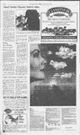
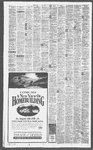
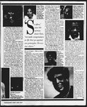
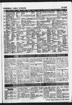
Show The Salt Lake Tribune UTAH/WEATHER Sunday, August 6, 1995 KE TRIBUNE WEATHER REPOR ARerrieee bo Statistics recorded through 6 p.m. yesterday Utah high 110 at St. George Utan low 38 at Randaiph Utah highest precip. 0.12" at Randolph 3 3 High pressure over New Mexico today will dominate the weather across the Salt-Lakealmanac. tegion over the next several days. Hot weather with plenty of sunshine is Sipe Settece bw expected to continue through at least Tuesday. There will be a chance for a [RES 0.00 Departure trom normal Precipitation since Oct. 1, 1994 high pressure continues to 0-50, Good: 51-100, Moderate; 101-200, seinefseepame 24 Ogder/Provo: Salt Lake & Utah counties - 105 in 1994 50 in 1928 Ponies Gace Good Te Tom. Te TUESDAY WEDNESDAY “Mostly sunny Mainly sunny Sunshine and Parflysunny;a ——Cloucés and and hot. andhot. patchy clouds. ‘Stray t-stonm. Sun, it may t-storm. 96/68 98/79 94/66 saved 90/60 Bskuhithickets hscrtenhiate ca)Ackee TODAY MONDAY TUESDAY WEDNESDAY i THURSDAY Mostly sunny. Sunshine and building Partly sunny andnot as Cleuds and ‘sun;it may clouds. warm. t-storm. 94/62 94/60 92/58 90/58 90/58 (St. George area temperatures average approx. 11 degrees higher than overall southwest region.) Southeast Utah 5-day forecast .TODAY MONDAY TUESDAY WEDNESDAY THURSDAY 61 Flagstett Brigham City 97 60 93 54 Page Bryce NP. 86 43 Bullfrog 104 75 Capitol Reet 91 57 Cedar Sity 93-58 Coalville 92 43 Delta 95 50 Duchesne 90.52 Escalante 92-53 Fillmore 94 59 Flaming Gorge 90 47 Green River 101 60 Hanksville 105 55 Heber Cty 94 47 Joseph 100 59 Laketown. 83 46 en Logan Manti Mitford Today Prost «193 GF. SBpe | tone 108 82 105 76pe Athens, 88 Bangkok 93 791 Seino 88 70t one | Beirut COLGRADO Aspen 77 58 85 558° | Bertin Boulder 87 B18 BIS Bermuda Colo. Spigs. 87 53 808 Bogota Beaver 87 157 0.09 62s | Buenos Ares GrondJct. 98-6780 688 Caro WAHO——SSCSC~*S«CCaigry . Copenhagen wa eo els Dubin ideho Fas 62 4@ ODI goBe fEKuT 0.05 | (gyton 97 65 SCT Oa Gere Pocaiein 90 8D sgt He Havan2 Rexbu as 49 $1 Sda HongKong SunValey | TwnFele Billings 82 Sr 4887 Bape | kata Snbul 95 Ba Sg Jarusalem Kiov 92 @zpe London MONTANA 93 61 86 84 78 86 72 59 93 69 75 73 80 73 90 87 73s 60pc 58pc 79 pc 56pe 43pC 68s 57sh §8pc 578 Ss Te 75pc 78sh 8267 pe «90 7c 81 63s 73 49s 73 57 pc 86 S4pc | Madnd 83 57s Kalispell 91 47 78 47 pc | Manila 90 77 sh Orem Park City 90 83 60 (50 W. Yellwsione 81 40 88 54s 74 70 53pc 59t 90 60 99 60 81 38 93 49 96 57 99 61 97 59 8142 S. 99 61 St.George 110 72 Vernal 91 49 92 68 94 55 Hot with partly Mostly sunny Partly sunny; a Clouds and Wendover to mostiy and hot. stray t-storm. ‘sun;it may ‘sunny skies. Zion Park 105/62 105/64 W. Valley 91 63 71s 58 93 64 52-4 St pe | MexicoCity | Montreal Moscow NEVADA Nairobi | Eiko 48 82/483 New Deni 012 & 43 $2 583 Oslo las Vegas 108 85 109 B18 Parc f 28 $1 95 588 | Rome | NEW MEXICO SanJjuan Albuquerque 98 71 95 G7/pe Santiago | Carsbad 95 68 100 7090 il 91 62 | 96 54 Tr | Tr 105.70 SentaFe 93 61 WYOMING Casper 80 S67 91 Gpe 75 57sh 67 86 73 77 83 90 54 88 52sh 79sh 51 pe 65t 64s 75 pe S4sh 76sh Singapore 86 75 8h ‘Sydney €2 445 Stockholm 17 @O | ToKyo 70 57sh 93 84 pe Cheyenne 8-52 0.01 91 COs ‘Evanston 86 56 1 858 Vancouver 70 Jackson Hole 81 93 87 Ge Vienna 76 6190 Rock 100/60 Be 90 568 | Toronto Warsaw Tropical moistureleft over from Erin will produce showers and thunderstorms, some with heavy downpours, from Indiana to New Jersey today. The Southeast will be very warm and steamy with a few thundershowers. A couple of thunderstorms will rumble across Minnesota, Wisconsin and lowa as heatin the Plains attempts to press eastward. 86 77sh 53 Price Provo Randolph Richfield Roosevelt Salt Lake Sandy Snyderville Great Falis nie Amsterdam 73 635 < we 98 few clouds. 100/60 eae 93 53 95 51 % 57 104 58 National Low: 31 in Fraser, Colorado; High: 119 in Bullhead City, Arizona nea nee neeNruasess DY ALOEORES, mee 108 2:06 am. 5:02 p.m. 87 Ogden shine and a 102/62 Moonset today Moonrise today. Nephi Tooele t-stormn. i 4 (\ 7) AK dl Augi0 Augi7 Aug25 Sep2 o s = Shown sre noon posllons of westher systems and Temperature bande are highs fr the Moderate ee Tepes rth vo 98 Bountiful Span. Fork Hot with sun- Mold ARIZONA Bianding Monticelio Sunshine and patchy clouds. Low Yesterday City THURSDAY : Coe 2 Ee 575-7000, $75-2499, 97-2006 Air Quatity - 533-7239 MONDAY Grass This evening} 8:39 p.m. Utab cinamon =e TODAY Tom. sourceFay Ban UYNetwork! This morning 6:29 a.m. : Ldd ech! Statisics recorded at the intermountain Allergy Clinic for yesterday Trees coe! weeds: High Highest 7 7 Noon oo” g" Gam . .2 2 3pm..6 6 1-3. Low;4-5, Minimal; 6-7. Moderata; 6-9. High; 10+, Ve " the region. There is a chance for a cooling thunderstorm by Wednesday ‘Wasatch Front 5-day forecast ~ ONA St NA 44 Record high for Sait Lake Record low for Salt Lake dominate the weather across Highway Conditions - 964-6000 or Temperatures are today's highs and tonight's tows. (860)492-2400 NA Unisgaithtut: 201-300. Very Unhestthtul Today Sait Lake City, Davis and Weber aoa The ive amount ot the sun's UV radiation that reaches the earth sunshineis expected to continue throughatleast Tuesday as ie19 “0.11 19.43 Departure from normal Hot weather with abundant a4 % Weber Ogsen County 1 0.00 Precipitation Precipitation this month cooling thunderstorm by Wednesday. i ‘Statistics recorded at the Utah Division of Air Quality through 6 p.m. yesterday. Certon Honszide Partcustes Ozone Salt Lake City ie 420«(NA SL &DavisCounty 16 42 81 84 58pc 53pc 75 56pc i Northern Utah City Hi Lo Prop. Hi Lo W City Yesterday Hi Lo Prop. Hi LoW Aioany Anchorage Atacta Atlantic City Austin Baltimore 7 71 020 $6 54 008 eo 71 Tr 74 @e 61 ker $2 Tipe $2. 73 (0.13 63 68 sh 95 75 98 75s 96 75 0.09 84 68 sh Levalowie: ‘Medison Memphis 82 73.124 7 e 88 74 207 78 73 a7 Se BS Ft Birmingham ‘Siomarck Besion G4 77 «0.02 we 59 72 68 001 90 726 22 6s 78 64c Modie Montgomery Montpelier 8 87 7 90 75 pC 33 7ts. 72 52 pe 84 68 pc 78 70 sh 76 66 8h Norfok s 78 ‘Okiahome Cty 90 71 Omaha 88 68 004 93 754 74s 87 68t Pittsburgh Portland,ME 75 86 sh 73 S56 pc Miami Milwaukee Charleston,SC 91 77 Tr 96 75s Charleston, WV 89 72 0.23 77 681 Charlotte 88 73 002 91 73t mo 87 «66 9.90 72 76 246 7 71 115 Nashville New Orleans New York Columbia. SC 91 74 94 72 pc Columbus, OH 70 68 3.04 77 69 sh Concord 74 63 0.06 73 54 pc Oasas Davenport Daytos: Des Moines Detro# Dover 6 75 86 68 72 88 80 96 % 7565 84 6c 68 313 78 67 sh 69 85 69t 72 017 84 69 pc 78 Tr 86 71 sh Duluth EI Paso Eugene 71 56 98 72 of 8S tr 77 6t 98 708 7% Se Greenadoro Harttord 9172 80 68 140 eo 7it 75 62c Kaneas City Littts Rock Los Angeles 86 68 0.01 a 74 72 88 721 $2 75e¢ Bh Bs Evansville 7S 72 241 87 7it Fairbanks 58 49 015 62 Sir Grand Rapids 84 69 0.01 86 65s Honoluly Houston Indianapolis Jackson, MS 90 95 78 88 Orlando Palm Spr Philadelphia 78 Tr 87 77 96 71 0.36 80 76 245 91 7p 78t 69¢ 72 pc | ; Providence Raleigh Rap City 88 77 9 78s 82.-«GB_—sT:« G3: 69's 85 67 Tr 83 68t 75 0.02 75 0.08 8 82 74 1,00 84 72t 92 76 0.03 90 76t 85 78 6.10 80 66c 91 75 Tr 94 76s 110 83 114 80 pe 94 77 0.26 84 67 sh 76 71 088 76 63 Tr 81 77 92 90 60 72 74 56 76 Tr 74 90 Tr 92 Plichmend Sacramento St Lous 97 72 90" SB 88 72 021 ‘Sioux Falts 6 & Tr 79 65 234 72 S4 pe 84 70 FC Tsenion Washington Wichita By 73 38 76 0.07 87 67 BA 71 3h 86 70 sh 92 721 San Diego 77 64 San Francisco 73 57 Savannah 82 76 ‘Spokane Springfield, IL Syracuse Tampa 90 86 72 91 Better Prepared For Incinerator @ Continued from B-1 State emergency planners agree the protective clothing issue wasridiculous. But overall, they are not as quick to jump the fed’s case — or to concur with Tooele thatthe skyis falling. “We believe that to date, the moneythat has come to the state has been well spent and that we have achieved the best level of preparedness to date that we possibly could,” said Kim Williams, spokeswomanfor the Division of Comprehensive Emergency Management. What's more, thestate’s figures on what has been received differ somewhat from FEMA’s and Tooele’s. Utah has gotten $20,247,403, aecording to the emergency-management division. Of that, Tooele has received $9,859,284; Salt Lake County $748,361; Utah County $998,042; and thestate received $8,641,716. 60 79 72 Tr 87 69 096 76 75 95 Utah Countyhas beendesignated a Protective Action Zone, potentially vulnerable to contamination from a drifting plume of agent vapor. Salt Lake County is considered safe from contaminaae because of its distance from D's chemical storage and indation area. But it would supply first r ders to support Tooele and prevent the spread of contamination. At the Sait Lake County Fire Department, where training with the protective equipmentis under way, there is confidence that crews could scramble quickly. But Assistant Fire Chief Butch Swenson agrees Tooele is not ready. For one thing, hesaid, it has no core group of responders. The Tooele city and county fire departments areall-volunteer. Salt Lake County would send trained personnel, protective clothing, hazardous-materials equipmentand a decontamination trailer around the Oquirrhs to help, Swenson said. However,if it happened today, it would be chaos, the chief said. “Thefirst thing we're going to do onthe otherside of that mountain is call the Tooele County sheriff for commandandcontrel. If they don’t have a core group of peopleto provideit, you can’t be- gin the incident command sys“Tooele County acknowledges ment has been siow to meet their public-safety needs as the date nears to fire up new chemical-weaponsincinerator. ee ome Se eee ee a ey B2pe 70sh 63c 75s the deficiencies, and in its next budget request, commissioners are not tiptoeing around the issue of moneyanylonger. They want $25 million for a 20person response team, components to complete its emergencycommunication network, 14 more alert and notification sirens, funding to ensure 24-hour medieal coverage and emergency-response automation equipment. “The resources are there to meet the needs we have,” said county spokesman Myron Lee. “We're at the point of impact. Our responders here in Tooele County should get the concentration of resources and money.” FEMA's Davis says local entities tend to lose sight of the congressional mandate to provide “maximum protection” ofcitizens in all eight stockpile states. Having an incinerator does not automatically confer “top priority” status, Davis said, because the Army considers continued storage of aging chemical munitions a greaterrisk. Underthat definition, Anniston Army Depot, Ala., was awarded the most emergency planning money -- $37 million. It has 150,000 people living in the Immediate Response Zone, the area closest to the chemical storage yards where protective At Anniston, Davis said, there are public schools literally sitting outside the depot gate. “You've got to admit Tooele’s South Area is a little bit isolated,” he said. TADSouth sits 20 miles southwestof the city of Tooele. While it has a huge chunk ofthe stockpile, its response zone is populated by only 2,500, mostly in Rush Vailey, Ophir, Stockton and Mercur. Despite all the angst over funding and fear about the incinerator, the one thing emergency planners agree on is the unlikelihood of a chemical accident outside the depot gates. Theyall have to plan forit, including the worstthat could befall the depot — an explosionandfire involving nerve gas and M-55 rockets. But they do not expect to eversee it. “The chancesof something catastrophic happening off post are a million to one,” said Williams. “Really extreme odds. But you still have to be prepared for that million and one chance because if it did happen,the results are really devastating.” Now,dining out at any of Snowbird’s highly acclaimed restaurants is even more memorable. Bring this ad in to the restaurants listed below any Sunday through Thursday, and for each dinner entrée you order, receive one free adult pass to ride Snowbird’s world famous aerial tram. Se comeupLittle Cottonwood Canyon this summer and enjoy some ofthe best food and most spectacular mountain scenery in the state, at Snowbird! Ra & PROFESSIONAL INSTALLA’ . @ CLEAN OPERATING ®@ UP TO 14 SEER ESTIMATES @ FREE om =Manwil= Jeigelta WILDFLOWER Call §21-6040 for more information or to make yourreservations. 1 Ww action would have to occur within minutes of an accident. FRE Brent Schroepfer shows off chemical-protection suit recently received bythe state. Tooele officials say the federal govern- ® ost mM Ses 8 73t 79 655 70 58 pe 97 74s Weather(W): s-sunny, pe-partly cloudy, ¢-cloudy. sh-showers, t-thunderstorms, r-rain, sf-snow flurries, sn-snow, Lice, Prop -precipitation, Tr-trace. Tooele Paul Franghtoo/The Salt Lake Tribune 57 pe 61 71t 625 Plumbing & Heating Inc. 2638-487] ——— 385 East 3800 South Since 1920 |