| OCR Text |
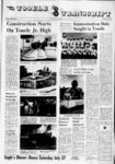
Show The Tooele Transcript whiih stands tm the dert a of Our Friday, July 26, 1963 uri-a- t portion of es h year. August, 1 1.2, was a successful at'empt expedition to follow these streak from a point several mile north of Knolls, Utah, to Pilot Spruit; on the Utah Nevada border. We, of course, were not the first to reconmnter all or pensions of this fascinating road, but we may wr have been the last, Sim thia set lion of the desert is used s a bombing range, the United States Air force Is rrlmunt to give person permission to travel upon it Among reiem attempts to explore the area were th e made by ( harles Kelly in 1029, Waller M Stoohey in 1916, and the present writer and his colleague every 8 year time THIS TIME OUR vrh.cle were three Trarkmastert and one Spry, provided by the Thiokul Chemical Company These were ideal for the trek, for with ease the tracked vehicle pulled over and dune (whiih osiupy several miles of the desert in the vicinity of Knoll), churned through ithky, gumbo mud, and climbed in and out of the steep ravine whiih !ash through the western slope of S.lver bland. We intercepted the r onei r road at 7 2 miles north of US. mud that bore un Highway 40 on a stretih of mistakable traces of the wheels of prune sihooner. Here the wagon did not follow one aftei the other so as to produce single set of traik. but invtcad sprrad out over an area of aeverai yard, testifying to the fait that some of the wagon either traveled abreast or pulled out and around deep and muddy rut cut by wheel rolling ahead of them. From time to time as we progressed across the desert, we encountered similar muititrackrd areas, the widest being in the vicuity of float, ng Island, not a great distanie beyond some abandoned 1 donner-ree- d trail GREAT SALT LAKE DESERT SECTION Donnr-Re- d Trod Dt rood present X 2 were ecavoted( Mound where ao unm were obondoned Mop drown by Key L) luu 6 Michflel J BulleH Intormohcn ood rojuh neither D J DerW Thorpe , 3in were posted by The grizzly bear la making one of Its last stands for sir vival in the two million acres of Yellowstone National Park. More than half of a total 474, fingerling sized brook trout scheduled for release Into the high country lakes of the Boulder, Manti and Uinta mountains have now been air dropped into the lakes. Department of Fish and Game spokesmen state. All plants of brook trout have been completed on the Boulder and Manti mountain areas and more than half of the brook trout scheduled for the Uinta lakes have now been planted. Planting of the 333,250 native cutthroat trout scheduled for these areas will get underway in These fish are now being hatched from eggs obtained from Strawberry Reservoir and commercial hatchery sources in Colorado. l, 250 t. through beau, and Basil Lajeunesse, the Fremont party made the trek from Redlum Spring in the Cedar Mountains to Pilot Springs between October 26 or 27 and Ouober20, 1645. The following year - on May 23 and 29 - a group led by Lansford W. Hastings and chronicled by James Cl) man, made the same journey from west to east. Finally, in the summer and fall of 1346, the Bryant-Russelthe Hoppe, and the the Harlan-YounDonner-Ree- d parties all made the 'fearful king drive" on the Hastings Cutoff (as this whole route south of the Fort Hall road came to be called). Some traveled the cutoff in their mad rush to get to the gold fields, and numerous eager souls braved it in the early 1650's. Thereafter the road remained unused until modern historians endeavored to unravel the secrets kept so well by salt, sand, and mud. FIRST THOUGHTS WOULD lead one to believe that, after all these years, the road would have been obliterated; and, indeed, in most places it has either been eroded away, surplant-e- d by modern highways, or completely garbled by the chuck wagons and jeeps of sheepherders and cattlemen. It can, of course, be followed across the Cedar Mountains, for Hastings Pass is still used, albeit infrequently; and there is a short dugway in Grayback that may have been constructed by members of the lead wagons in 1846. But out on the mud flats themselves, for mile after mile, the old road stretches out in unbelievable clarity, not as ruts cut deep by the passage of numerous wagons, but as streaks of black on gray, or, in certain places, white on gray - a phenomenon undoubtedly caused by the churning up of different colors of mud and sand with subsequent filling in and flattening out by the action of water forty-n.ner- Trek Across the Salt Flats On August 17, 1962, an expedition (jocularly termed Expedition Mirage") was conducted across the Great Salt Desert in the wake of the Donner-Reeparty. The trail is called the Donner-Reetrail, not because the Donners and the Reeds pioneered the road, but because their unfortunate experiences along it made their names seem paramount to later historians and map makers. Actually the first white men to cross this desert - perhaps the first men of any race, since its forbidding nature would have discouraged red men from venturing upon it - were members of John Charles Fremont's third expedition. Led by the scouts Kit Carson, Lucien Maxwell, Auguste Archam- d d s e It was pioneering in the truest sense when copper production from ore began in Utah 59 years ago. Traditional mining practices gave way to new techniques and equipment appeared mass production methods on the scene. The result was a great new and spectacular industry for Utah. low-grad- n dollar expansion program Today, Kennecott is engaged in a vast to increase copper production in Utah. Again, pioneering is a vital, necessary tool for progress. As one of many examples of pioneering in the expansion program, Kennecott research scientists delved into the production of precipitate Mine. copper, which is recovered from overburden dumps near the Bingham Canyon 100-milli- ooo These scientists developed new methods and equipment that will be a major factor in increasing precipitate copper production from the present level of 1800 tons a month to 6000 tons! Kennecotts pioneers of today are creating a brighter future for copper production in Utah through the expansion program. Inevitably this assures a longer life for the economic benefits that result from Kennecotts operations. Directly and indirectly, these benefits reach all Utahns. Kennecott Copper Corporation wagon WE LOST THE traiks in the dunes, a from previous experience we knew we would, fur the shifting sand do not retain impressions which the mud does But after a brief searih, we picked them up again The traiks were head.ng, not for Pilot Peak, however, but in a southwesterly direction, for all the world as if the pioneers had changed their minds and wished to use the pas in the vicinity of present day Wendover. Actually, they were making a wide swing to the southwest, only to turn baik toward Pilot Peak after approximately five miles. The reason for this mysterious switch i perhaps not o mvstcriou after alt. Althotgh the diaries do not say so, the summer of 1346 must have been inordinately wet at least - for it will be remembered compared with recent summer that Edwin Bryant wrote that a he traveled across the flat, the mud "gradually became softer, and our mule sometime sank to their knee." Perhaps this southwesterly course was set to avoid extremely muiky areas to the north. In any event just as the road begins to turn to the northwest, it suddenly divides, onehalf of it continuing on toward Wendover for a mile or so before swinging back and joining the other half, Perhaps here again exceptionally muddy conditions caused this diversion. SINCE MOST MAP makers have not personally Investigated this terrain, the peculiar change of directions is not normally recorded, generally the road is depicted as streaking to the northwest as straight as an arrow for Pilot Peak. Interestingly enough, one of the first maps ever published concerning the Hastings Cutoff - T. H. Jefferson's Map of the Emigrant Road from Independence, Mo, to St. Francisco, California (New York, 1349) - makes something of the same mistake as its successor and show the road stretching due west (rather than northwest) from Hastings Pass in the Cedar. This would make the route run south of the present highway rather than north, a condition contrary to fact. Since Jefferson is generally accurate in depicting the route in other areas, one is encouraged to conjecture that he was so preoccupied in getting across the desert that he neglected to make careful observations, lbs map does at the same time illustrate a sudden shifting to the' north just before it reaches Silver Island (called Fire Island by Jefferson) and then takes it west to the "Good Water and Grass" and the "Bonark Wells" thdt nestle beneath Pilot Peak (which Jefferson forgets to depict altogether). The map accompanying West from Tort Bridger corrects some of Jefferson's errors - among the most important is that it shows Pilot Springs is not due west of Hastings Pass and at least starts the pioneers off in the right direction from the Cedar Mountains - yet at the same time it creates some errors of its own , calling Floating Island, Crater Island and depicting the crossing of Silver Island farther south than was actually the case. And, of course, it does not show the great bend in the road toward Wendover. Dr. David E. Miller and his colleagues first noticed this bend in 1956, but the weather was such that they could not pursue it. The following year. Dr. Gerard S. Cautero and the present writer managed to make the entire long drive by jeep but were unable to clock the actual distance of the bend because our mileage indicator had broken. Nevertheless, from evidence obtained from these and other trips, Dr. Miller was able to produce a relatively authentic map of the area, although still not giving enough prominence to the bend in question. The expedition in the Trackmasters and Spryte made it possible for our cartographer - J. Derle Thorpe, research engineer for the Utah State Road Commission - and his as- 12 sociates to construct the accompanying map. IN OUR PROGRESS across the desert, we encountered the ravages which mud, salt, sand, and thirst had made upon wagons and animals. In several spots we found the bones of oxen - perhaps the very ones which James Reed had turned losse to fend for themselves when they became maddened from lack of water - and, in spite of previous incursions upon the flats, we found some artifacts at the site of the abandoned wagons. Four low mounds still exist, and in them and on them, were pieces of metal, wood, and leather straps, all encruste with salt and sand and most of them ready to disintegrate at the touch of a hand. Most intriguing among our finds was a small spoon and a little compass, the latter so corroded as to defy almost all our attempts to open it. Both objects speak eloquently of the heartbreaking necessity for the pioneers to jettison theic intimate belongings. We ended our journey at the Pete McKellar ranch where Pilot Springs still sends up a cool and refreshing flow of water Although we were not parched as had been those early travel ers who had moved with such agonizing slowness along their route, we were able to appreciate the drinks we sipped from And looking back over the the Bonark Wells. desert we had just crossed, we tould understand something of the feeling of the pioneers upon finally arriving at this shady oasis. High Blood Pressure I of a series of on healih column about your Utah heart, prepared by th Heart Association and published by this newspaper at a public ( This sen Ice). Almost everyone, at one time or sno'her, has played wish a garden hose When you turn the ftorrle wide open, the water spravs broadly and close by; sou can hit a target with a great deal of force The mailer the norrle opening, the higher the pressure of the water In the hose. Thl tine principle I at work in h'ph blood pressure. Blood pressure (we all have It) I 'he force of the blood Thla against the artery wall force is generated by the heart It pump or beats a It keeps the blood moving through the arteries, the vessels that carry hlood from the heart to all parts far-of- of the body. ARTrRIFS COME in various Think of the largest one, the aorta, at a tree trunk. The main arteries branch out from the trunk into smaller and smaller ones that end in microscopic twigs called "arterioles" These tmv arteriole are Involved In high blood pressure. For various reasons, arteriole mav become constricted or narrowed. and, as happens In the hose when the nozzle is screwed down, the pressure behind them - in the arteries goes up When this increased pressure persists, the condition Is called high blood pressure or hypertension. An estimated five million American suffer from some degree of hypertension. In the garden hose, the increased pressure Is unimportant. The water la forced out the open end and the pressure is relieved But your circulatory system is a closed circuit, and persistant, high blood pressure uncontrolled over a period of time ran have serious results. ONE REASON is that hypertension adds to the work of the heart When arterioles tighten, the heart has to pump harder sie to force blood through the narrowed passages. After long periods of this overwork, the heart may become enlarged and In- capable of performing at normal capacity. The arteries, too, may be damaged by years of the wear and tear produced by high blood pressure Regular physical examinations are the best way to check on your blood pressure. A visit to the doctor is important because many people with hypertension do not have any symptoms and sometimes the symptoms that do appear are similar to those found in other conditions. Regular check ups also enable your doctor to decide whether a raise in blood pressure Is persistent or temprary and whether treatment is necessary to lower the pressure before serious harm is done. The Utah Heart Association txiints out that in the past ten years or so, many new aids have been developed to help the physician diagnose and treat hypertension, including a wide variety of new drugs. You can learn more about the condition and the progress which is being made against it by asking, the Utah Heart Association, 250 E. 1st South, Salt Lake City, for a free copy of a booklet entitled, "High Blood Pressure. From 10,000 to 12,000 gallons of hot water were discharged at every eruption of Old Faithful Geyser in Yellowstone Nat'onal Park. Fishing Bridge in Yellowstone National Park was built In the summer of 1937. sun-bak- Reprinted by permission from the Utah Historical Quarterly, official publication of the Utah Historical Society, 603 East South Temple, Salt Lake City. The Lower Falls River in National Park form waterfall twice the Niagra Falls. lowstone Croup searching a mound at site of an abandoned wagon of iome pioneer party. of the Yel- Yellowstone a 308 foot heighth of |