| OCR Text |
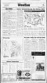
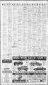
Show Allen's Super Save Markets fw? Current Time, Temperature and V, Jfl p? p?i Vf. Hlv Ttf U" 3 Wcathcrline 1 wr fc.'fl fSTMTI A . t'ff J V 1 tlw ll3JliMulLj 344-6OO- O The Daily Herald Monday. December 4, 1995 Idaho temperatures dip below zero Associated Press UTAH SALT LAKE AND PROVO: Tonight mostly cloudy and cooler. A few light rain or snow showers mainly near the mountains. Lows near 30. Tuesday partly cloudy and cooler. Highs in the mid- - to upper 40s. Chance of rain 30 percent today mainly Ogden area and less than 20 percent tonight. NORTHWEST UTAH: Tonight mostly cloudy. A few light rain or s snow showers mainly near the mountains. Lows to lower 30s. and cooler. lower Extended to partly Highs cloudy Tuesday forecast, Wednesday mostly cloudy. Lows in the 20s to lower 30s. Highs s to lower 50s. Thursday and Friday partly cloudy. Lows s s to lower 50s. to lower 30s. Highs SOUTHERN AND EASTERN UTAH: Tonight and Tuesday parts to upper 30s. Highs mostly in the 50s. Extendly cloudy. Lows ed forecast, Wednesday through Friday partly cloudy. Lows 20s to By The mid-20- mid-40- s. mid-40- mid-20- mid-40- mid-20- mid-30- s. Highs 50s and lower 60s. DIXIE: Tonight and Tuesday partly cloudy. IDAHO NORTHERN IDAHO: Tonight partly cloudy. Lows 20 to 30. Tuesday partly cloudy. Highs in the 30s. Extended forecast, Wednesday through Friday cloudy with a good chance of snow and rain each day. Locally breezy. Lows in the 20s. Highs in the 30s to the lower 40s. CENTRAL IDAHO: Tonight partly cloudy. Lows 15 to 25. Tuesday increasing clouds. A slight chance of snow west. Highs 25 to 35. Extended forecast, Wednesday through Friday cloudy with a good chance of snow each day. Locally breezy. Lows 10 to 25. Highs in the s through the 30s. SOUTHERN IDAHO: Tonight breezy this evening. Partly cloudy. Lows 20 lo 30. Tuesday increasing clouds. A slight chance of snow and rain. West. Highs 35 to 45. Extended forecast. Wednesday through Friday mostly cloudy with a chance of valley rain and mountain snow each s to the mid- - 30s. Hichs in the day. Locally breezy. Lows in the mid-20- mid-20- 40s. NEVADA NORTHERN AND CENTRAL NEVADA: Tonight mostly cloudy with a slight chance showers. Snow level 6,000 to 7,000 feet. Lows upper 20s to upper 30s. Tuesday chance of showers mainly north. Snow level near 7,000 feet. Highs lower 50s to lower 60s. SOUTHERN NEVADA: Tonight partly cloudy. Lows mid-30- s to mid-40- s. 60s lower lower 70s. to Hishs Tuesday partly cloudy. ARIZONA STATEWIDE: Tonight variable clouds far north otherwise fair skies. Lows lower 20s mountains to the middle 50s deserts. Tuesday variable clouds north otherwise mostly sunny. Highs in the upper 50s mountains to the middle 80s southwest deserts. By The Associated Press More than 6 inches of snow fell overnight in Stampede Pass, Wash., and predawn temperatures today dropped below zero in parts of Idaho and Minnesota. Fog and clouds blanketed the West Coast. The nation's low temperature at 3 a.m. was 2 degrees below zero at Grand Rapids, Minn. An hour later it was 3 degrees below zero in Des Moines, Iowa. A strong cold front was expected to move out of the Pacific Northwest and into the northern Plains and central Intermountain region today, pushing strong winds towards the Rockies. Wind gusts exceeding 50 mph were possible. Rain or snow was called for from the northwest Plains to Minnesota and upper Michigan. Snow accumulations could reach 6 inches in the Cascades and northern Rockies. Scattered rain showers were headed for the Gulf Coast to the southern Appalachians, the region, and the southern East Coast. Thunderstorms were possible from southeast Louisiana to parts of Alabama. Florida and South Carolina. Sunday's hot spot in the Lower 48 was Del Rio. Texas, where it was 88 degrees. The coldest reported temperature was minus in Caribou. Maine. Thirties and 40s were forecast in New England, the Great Lakes region and Pacific Northwest; 50s in the Midwest and Central Plains; The AccuWeather forecast for noon, Tuesday, Dec. 5. Bands separate high temperature zones for the day. 7T20s. & FRONTS: ; -. :; -- v. COLD WARM H L E3 HIGH LOW SHOWERS 0 RAIN and West 60s in the 70s in the Southeast, South Coast; and Southwest deserts; and 80s in southern Florida and Texas. Other reports at 4 a.m. EST mid-Atlant- ic - 3s V"i Jtv . Via to: Vt- - V:!r - . (atmospheric conditions not avail- able for many cities): EAST: Albany, N.Y., 40 cloudy; Atlanta 57; Boston 38 foggy; Buffalo 37 cloudy; Charleston, S.C., 52; Chattanooga 57 cloudy; Cincinnati 35; Cleveland 30 foggy; Detroit 37 cloudy; Jacksonville 50 fair; Key West 70 fair; OUR BODY THERMOMETER As the temperatures begin to plummet, our internal body ther- yV'XiWtn r 5. mometer kicks into high gear. !t sends out warning signals and. as a result, the blood vessels contract, pulling the warm blood away from our skin's surface. This quickly affects our feet and fingers. The body then pools the blood around the cavity of our chest, protecting our vita! organs. Conversely, when the heat is turned up the body reacts in a completely opposite way, sending blood to the skin's surface to induce sweating that cools the body. So on chilly days, make sure to dress in layers to keep that thermometer steady. DRY HEAT No, we're not talking about Arizona's climate. I'm referring to the climate in our homes during the winter season. As air from the cold outdoors is used to warm our homes, the humidity is dramatically affected. Cold air can't hold as much moisture as warm air. so the winter air supply enters our homes drier and humidity levels may drop below 20 percent. This dry air promotes chapping skin and lips and V Carol Azure, Cherry Hills Elementary School national Temperatures Temperatures indicate prexious day's high and overnight low to 7:32 a.m. EST. Amarillo Anchirai;e 61 Lo 37 37 33 3 9 Ashi-wll-e 66 Atlanta Atlantic Ciiy Austin Baltimore Billings Birmingham Bismarck Boise Boston Brownsville 6S 47 46 54 54 55 52 33 57 25 40 38 S3 6X Hi Alhun.N.Y. Albutiucrqiii 40 62 56 K6 63 42 71 3S 4X Pre .02 clr clr cdv .03 clr Oilk dr tdv cd cdy clr clr 1.30 clr cdv .OS rn .07 cdv .01 cd Buffalo Burhnaton.Vt. Casper .C. Charleston Charleston.W.Va. Charlotte.S.C. Chevenne Chicago Cincinnati Cleveland Columhia.S.C. Columbus.Ohio Concord.N.H. Dallas-F- t Worth Davton Denver Des Moines Detroit Duluth El Past) 47 37 45 W 57 66 44 57 58 53 71 58 31 70 56 50 53 53 34 73 30 30 37 47 .06 .05 clr cdv cdy sn 3X .11 clr 49 25 30 30 29 42 27 20 48 28 30 22 cdy clr 31 .OX Fairbanks Farco 65 -- 29 32 57 31 cdv 12 42 6 33 5() cdv Hartford Spatld Helena Honolulu Houston 4X 40 38 cdv clr 73 clr X5 55 cdv Indianapolis cdy Jackson.Misv 59 74 28 58 clr clr .08 Flagstaff Gra'nd Rapids Great Falls Greenshoro.VC. cdv 51 44 87 26 30 I cdy clr creates more static electricity. What can you do? Getting a cdv cdv Devoe WONDERTONE Eggshell Latex 3449 cdy clr 36 clr 42 clr clr clr clr cdy cdv cdv .02 .05 clr .05 clr Eansille Retail $21.02 Our Best Durable Eggshell Finish Washes How often does the opportunity arise to position yourself at the forefront of a dynamic, rapidly expanding Beautifully I lowing Fad rVu . U'alr C&xnttn Over 780 Colors Not very often. FLURRIES SNOW ItH H m i ICE SUNNY PT. CLOUDY CLOUDY cloudy; Boise 44 cloudy; Casper 42 wind; Great Falls 42 wind; Honolulu 75 fair; Las Vegas 45; Los Angeles 55 foggy; Medford 42 rain; Pendleton 52 wind; Phoenix 53; Portland, Ore., 46 rain; Reno 53 partly cloudy; Salt Lake City 5 cloudy; San Diego 58 foggy; Seattle 40 wind; Spokane 40 wind. Knoxville 53 cloudy; Macon 43 fair; Miami 69 fair; New York 51 cloudy; Philadelphia 52 cloudy; Pittsburgh 37 foggy; Portland, Maine, 24 partly cloudy; Richmond 52 cloudy; Tampa 57; Washington 47 cloudy. WEST: Albuquerque 40 partly cloudy; Anchorage 0 partly 1 24 HRS7 DAYS rizing the strength of storms such as hurricanes and tornadoes. humidifier is the best answer. Oth- er options, such as boiling water or leaving tubs filled with water, waste energy, can be dangerous and aren't as effective. MEASURING WIND Wind has been measured for many years using the Beaufort wind scale. This was developed by Sir Francis Beaufort of the British Royal Navy back in the early 1800s. He devised the model so that reports of wind could be more specific and scientific, rather than relying on adjectives such as "breezy," "calm" or "windy." Beaufort's scale ranges from 0. which indicates calm winds, to 17 indicating gusts in excess of 75 mph. His model was used mainly by sailors. Other scientists have used the same principle for catego THE TALE OF TAILS Clouds hold the clues to upcomif you know ing weather events what to look for. Long before technical eyes were in the skies watching the clouds and upcoming storms, forecasting was left to the eyes of those below. Farmers especially became quite the forecasters just by watching the clouds go by. They knew that if the cumulus clouds (the ones looking like cotton balls) were smaller at sunset than at the noon hour, nice, dry weather would continue. Mares tails were also watched for weather clues. As folklore has it, if the tails point up, watch for a storm. If they point down, the weather will be dry and uneventful. Digued! mm - IMAGES OI r A I T H Investing in fine I DS paintings and sculptures is mm both leasihle and rewarding. Iimics o r niili includes mark three hundred beautiful, photographs full-col- that will allow you our family to evperience I DS life and history and i through the sensitivity, power, and emotion of great artists. You can bring the priceless artwork held by the Museum of C hurch History and Art into your own home. A magnificent volume lo own or give. Including: V tree imprinting CUSTOMER SERVICE Gift certificates, largest selection of LDS products anywhere, price matching, special orders. t'PS shipping, major credil cards accepted, missionary discount. Opportunities like this usually knock only once. 1 E3 TRIENDI gallon 373-713- EZ3 rRtt Girr wrapping Non-Y- e company? CALL E Associated Press Can the weather be too cold for snow, as we so often hear? Not really. Temperatures are actually never too cold to produce snow, though it may seem like it simply because the coldest air we experience comes from the north and northwest. These are areas that lack large bodies of water. So as storm systems approach, there is a lack of moisture and therefore lack of snow. It's is easy to see why people may believe that the colder the storm, the better the chance of not seeing snow. If, however, the storm is racing in from the west or south, watch out! These are the ones that bring the heavy stuff. X it By The Associated Press Inc. 1995 AccuWeather, 1 By Rebecca Kolls Newspapers : X1 Xj 8S STATIONARY Pressure jT t's never really too cold to snow v J 30s BOs Knight-Ridd- : "JnVV( Mid-Atlant- ic Partly cloudy .? I Deseret Book 170 NORM 100 WEST fOVO 373-313- 1 53 EAST MAM AMERICAN FORK SI '756-528- 2 |