| OCR Text |
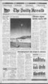
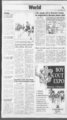
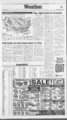
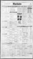
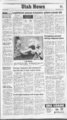
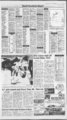
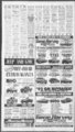
Show mmm? The Daily Herald The Accu-Weath- btj 50s VST. onW mid-30- s. UTAH Salt Lake, Ogden and Provo: Tonight low clouds and fog with areas of light snow. Lows Saturday morning low clouds and . fog with areas of light snow. Vari-able afternoon cloudiness and hazy with a slight chance of snow. Highs in the 30s. Chance of measurable precipitation less than 20 percent through Saturday. Western Utah: Tonight widespread low clouds, fog with areas of light snow. Fog locally dense. Lows Saturday morning low clouds, fog and areas of light snow. Variable afternoon cloudiness with a slight chance of rain or Jk OS 5-1- 5. mid-30- mid-30- mid-30- "Vx FRONTS: Pressure H L HGH LOW Via Associated PM STATIONARY WARM COLD Tmjos 1S93 S S SHOWERS Accu-Weathe- except 30-3- 5 Inc ICE SNOW FLURRIES PT. CLOUDY SUNNY extreme south. s. Monday and TuesHighs with a chance of rain or day cloudy snow mainly south. Lows teens north and 20s to lower 30s south. Highs 35-4- Lows variable hieh cloudiness. Cold Arctic air mass bears down on East By The Associated Press Fog and clouds shrouded much tier, in the 40s and 50s across much of the rest of the nation, in southern California and in the 70s in south Florida and southwest Arizona. Seattle posted a high of 63 degrees on Thursday, breaking the previous record for the date of 62 set in 1978. Sacramento hit 70, breaking its previous record of 64 in both 1984 and 1991 The high in Eureka was 78, breaking the 1963 record of 72. the 60s of the nation's western half early central Florida, and Skies were clear over the in today. Northeast. The far West enjoyed unseason- -' ably warm temperatures on Thursday, with record highs broken in Seattle and in Sacramento and Eureka, Calif. Rain was forecast for California today as a vigorous Pacific disturbance turned inland. Temperatures were expected to The high for the nation on rise today from the Ohio Valley east to New England and the Thursday was 81 degrees at Monstates, but an advancing rovia, Calif. cold front sweeping down out of Other reports at 5 a.m. (atmosCanada was expected to banish the pheric conditions not available for some cities): weather by Saturday. spring-lik- e East: Albany, N.Y., 16 fair; Highs today were forecast to be 44 cloudy; Boston 28 fair; northern Atlanta in 20s and 30s. across the . mid-Atlant- ic Buffalo 34 windy; Charleston, S.C., 45 cloudy; Chattanooga 36 cloudy; Cincinnati 32 fair; Cleveland 31; Detroit 28; Hatteras 40; Jacksonville 51 rain; Key West 67 fair; Knoxville 33 partly cloudy; Macon 34 fair; Miami 64 partly cloudy; New York 33; Philadelphia 29; Pittsburgh 30; Portland, Maine, 13; Richmond 29; Tampa 57 cloudy; Washington, D.C., 30. Central: Birmingham 43 fair; Bismarck 20 foggy; Chicago 29; Denver 21; Des Moines 27 foggy; Fort Worth 47 foggy; Indianapolis 27 partly cloudy; Kansas City 31 foggy; Little Rock 42 partly cloudy; Louisville 32 fair; Memphis 45 partly cloudy; Nashville 37 partly cloudy; New Orleans 48 cloudy; North Platte 28 foggy; Oklahoma City 40 rain; Omaha 28 foggy; 35 southwest. WASHINGTON Western Washington: Tonight Monday and Tuesday mostly cloudy with a chance of mostly cloudy with a chance of showers. Lows 35 to 45. Saturday rain in the valleys and snow over partly cloudy. Highs in the 50s. Eastern Washington: Tonight the mountains. Lows mostly in the mostly cloudy with a slight chance 20s. Highs mostly in the 30s. Central Idaho: Tonight in- of rain mainly east slopes Cascreasing clouds. Lows 15 below to cades. Lows upper 20s and lower 15 above. Saturday mostly cloudy. 30s. Saturday mostly cloudy with local fog. Highs upper 30s to Highs around 20 to the Extended forecast, Sunday partly MONTANA cloudy. Lows 15 below to 15 of East the divide: Tonight above. Monday and Tuesday most5 to 20 but 20 to 30 Lows clear. in rain w of ith a chance ly cloudy the valleys and snow over the east slopes of the Rocky Mounmountains. Lows 15 below to 15 tains. Saturday partly cloudy west and continued sunny east. Highs above. Highs in the 20s and 30s. 35 to 50. inIdaho: Southern Tonight West of the divide: Tonight and clouds west partly creasing cloudy east. Lows teens and 20s areas of low clouds and fog in the west and near zero to 10 above valleys with increasing high clouds east. Saturday variable clouds west higher elevations. Lows 15 to 25. s Saturday a few snow flurries. and partly cloudy east. Highs s west and upper 20s Areas of low clouds and fog in the to s east. Extended fore- valleys with cloudy skies higher to cast, Sunday increasing clouds elevations. Highs 25 to 40. west and partly cloudy east. Lows teens and 20s west and near zero to 10 above east. Highs in the 30s to s to lower 40s west and s east. Monday and Tuesday mostly cloudy with a chance of rain or snow. Lows mostly in the 20s west and zero to 15 east. Highs in the upper 20s and 30s. mid-40- s. fog north locally dense. Otherwise Press in- s s. Eastern Utah: tonight areas of CLOUDY WYOMING Tonight dear except for patchy fog. Lows from 15 to 25 with zero to 15 below southwest. Saturday partly cloudy far west with a few snow showers otherwise mostly sunny over the state. Highs from the upper 30s to lower 50s. 20 to to clouthe mid-30Saturday mostly dy with a slight chance of rain. Highs in the 40s to the mid-50Extended forecast, Sunday variato the ble clouds. Lows mid-20- s mid-30- s. Highs in the 30s to the 5. RAIN valleys. IDAHO 35-5- 0. r, mid-50- rain. 5-- mid-40- mid-40- s. Rapid City 24; St. Louis 33 clouPaul 29 fogdy; Minneapolis-St- . gy; San Antonio 50 cloudy. West: Albuquerque 27; Anchorage 5 snow; Boise 22 fair; Casper 23 windy; Fairbanks minus 5 cloudy; Great Falls 33; Honolulu 73 fair; Las Vegas 49 cloudy; Los Angeles 60 cloudy; Medford 58 rain; Pendleton 28 foggy; Phoenix 54 partly cloudy; Portland, Ore., 44 cloudy; Reno 35 cloudy; Salt Lake City 20 foggy; San Diego 58 cloudy; San Francisco 54 cloudy; Seattle 54 partly cloudy; Spokane 32 cloudy. International: Calgary 23 foggy; Montreal 27 snow; Ottawa 27 cloudy; Regina 14 fair; Toronto 32 partly cloudy; Winnipeg 9 fair; Mexico City 50 partly cloudy; Acapulco 75 ; San Juan 74 fair. mid-30- mid-30- There's only mid-20- one way to mid-30- Treasure Valley: Tonight mid-20- come out ahead of the pack. 5. Southeast winds 5 to 10 mph. Saturday variable clouds. Highs mid-30- Friday Temperatures indicate previous day's high and overnight low to 8 a.m. EST. Hi.Lo.Prc.Otlk AbQene.Texas AlbanyJJ.Y. Albuquerque Amanllo Anchorage Atlanta Atlantic City Austin Baltimore Baton Rouge Billings Birmingham Bismarck 46 39 cdy clr clr 36 15 48 21 42 25 .01 ch-O-S 04 .15 sn 60 41 44 23 56 48 48 25 69 42 47 26 62 34 42 17 Boise Boston 36 19 38 24 Bridgeport Buffalo Burlington,Vt. 41 21 .22 cdy sn cdy cdv cdv clr cdv cdv cdy cdv cdy 34 30 sn 32 09 Cflspcr 32 20 Charleston.W.Va. Charlotte,N.C. Chattanooga Cheyenne Chicago Cincinnati Cleveland Colorado Spgs Columbia ,b.C. 48 22 62 33 61 33 39 20 52 23 49 24 clr clr cdy cdy cdy clr cdy sn 41 26 sn 13 01 65 30 clr cdy Columbus.Ohio Concord.N.H. 46 22 sn 30 05 Corpus Christi Dallas-F- t Worth Dayton Daytona Beach Denver Des Moines Detroit Duluth El Paso Eugene Fairbanks Flagstaff Flint Grand Junction Grand Rapids Great Falls Green Bay Greensboro ,N.C. Harrisburg Hartford Spgfld Helena 67 56 52 47 clr cdy cdy 34 14 Honolulu 78 72 Houston Indianapolis Jackson.Miss. Jacksonville Juneau Kansas City Knoxville Lansing Las Vegas Lexington 68 53 48 24 sn 67 58 36 21 31 26 44 25 42 24 53 30 53 42 rn clr clr cdv cdy clr cdy cdy 12 -- 12 17 cdy 43 29 42 22 cdy cdv 43 28 cdy 53 30 cdy 41 29 sn 59 25 cdy 45 23 sn 32 19 53 26 cdy cdy clr cdy cdy 67 32 cdy 64 48 rn rn .82 22 18 30 cdy 59 29 cdy fly 43 24 45 51 30 Lincoln 36 26 Little Rock 61 42 Los Angeles 76 W 60 10 Lubbock Macon 53 32 64 33 Madison Medford Memphis Miami Beach 47 27 a .17 50 62 Midland-Odess- .02 43 69 50 60 38 70 65 49 30 clr cdy cdy clr cdv Hv clr cdy cdy .01 .02 cdy cdv cdy clr 47 33 sn PaJ 28 27 Mobile 66 42 Montgomery Nashville New Orleans 64 30 58 33 64 44 New York City 44 30 Newark 42 27 cdy cdy cdy cdy cdy clr Hr Milwaukee Mpls-- Norfolk,Va. North Platte Oklahoma City ' Omaha Orlando Peoria Philadelphia Phoenix Pittsburgh Pocatello Portland,Maine Portland,Ore. Providence Pueblo Raleigh-Durha- RapidCity Reno Richmond Roanoke Rochester,N.Y. 52 26 36 26 43 39 34 28 cdy 72 56 cdy 52 24 cdy 45 29 76 52 sn cdy 44 26 28 02 28 10 53 43 34 23 38 15 60 26 37 20 clr cdy cdy clr cdy clr 46 34 cdy 55 24 57 24 cdy cdv 29 28 sn cdy .03 .49 cdy clr cdv cdy .05 Rockford Sacramento St Louis St Thomas,V.I. Salem,Ore. Salt Lake City SanAngelo San San San San 46 Antonio Diego Francisco Jose SanJuan.P.R. Santa Fe St Ste Marie Savannah Seattle Shreveport Sioui City Sioux Falls South Bend Finr.i r,SATTBESS lr irtlSMiSjrtrM W" ' K noiKii ranHEA-PC MUST BE BETS HUB W Vs tf N 33 16 49 41 59 48 70 56 68 53 68 m 80 72 cdy .02 cdy cdy clr cdv cdv clr 2k cdv cdy .18 cdy cdy clr 35 m clr 44 26 65 45 63 43 clr cdy cdy 55 47 32 29 33 29 50 27 68 54 53 32 84 73 56 36 .05 clr clr cdy cdy 31 Springfield.111. 51 26 Spnngfield.Mo. Syracuse Tallahassee Ptrsbg Tampa-S- t 50 33 33 22 67 42 71 56 Toledo 46 29 Topeka 46 33 Tucson 72 49 Tulsa 48 41 Waco Washington,D.C. 52 47 50 29 75 60 41 24 cdy cdy clr sn rn cdy sn cdy cdy cdy cdy cdy cdy cdy clr sn Wilmington.Del. 45 27 sn Yakima 43 22 cdy Youngstown 41 25 sn Yuma 77 56 cdy Palm Beach Wichita Wichita Falls W Wilkes-Barr- e 1 413 KO 3 PC. SET 41 i mid-40- s. hu! If mid-40- mid-30- Idaho Panhandle: Tonight 5 DRAWER CHEST $4 fa 2X4 Unfinished I fl as Wood Only in- American Heart Association 8 HOURSI 3 HEART DAYEED Zmm AMER3GAM l&ADE IRON OftUT POIYDEOC .11699 DUTY Similar To s169 95 $41.00 af POLYDECK KQM C?LY POLVDECK SOETOQ $41.00 CAMEL DAYEED METAL DUNKDED POUTECCtQ $188 Red, White, Clue I HEART DAYEED White Brass METAL BUNKS Rsd, White, Bluo Frama Only ft ONLY!!! 4 CO Twin, Full, 6 DRAWER CHEST 5. creasing clouds. Lows 25 to 30. Variable winds 5 to 10 mph. Saturday mostly cloudy with a slight chance of rain. Highs in the 40s. NEVADA Northern and central Nevada: Tonight a few showers this evening west, otherwise partly cloudy. Slight chance of snow showers FT13 1 r Magic Valley: Tonight increasing clouds. Lows 10 to 15. East winds 5 to 10 mph. Saturday partly s to the cloudy. Highs n -- to the 2X6 HEAVY FE3E1ER 1E3 35 46 s BOOK CASE BUNK FULL E.CH ... OUEEFJ EACH $333 ICO 3 PC. SET! FULL EACH ... QUEEN EACH 40 f I4ilnl-1fIl"l"J-f- )l 103 123 123 '41 Spokane trzr set SS&V. rI. 23 5. mid-40- mostly cloudy. Lows teens to By The Associated Press mid-60- s. mid-50- mid-30- s. mid-20- Highs mid-30- mid-40- creasing clouds. Lows s. mid-40- s. s. Northern Idaho: Tonight mid-20- Southern Nevada: Tonight mid-50- snow mainly south. Highs mid-20- s and 40s and 30s north and mid-30- s south. Extended forecast, Sunday morning low clouds and fog north variable cloudiness south. Lows to s s to partly cloudy. Lows Saturday mostly sunny. s to Highs COLORADO Tonight becoming partly cloudy mountains and west, mostly clear east. Lows 10 to 25 with 5 below zero to 15 above mountains and high valleys. Saturday partly sunny mountains and west mostly sunny east. Continued warming trend. s Highs in the upper 40s to 45 and 35 mountains to east, high s. mid-40- mid-teen- Saturday partly cloudy. mid-50- s mid-40- 0. 60s east. Lows teens to Saturday areas of morning fog north locally dense. Variable cloudiness. Highs 30s s to and 40s north, south. Extended forecast, Sunday variable high clouds. Patchy morning fog. Lows teens to Highs 30s to lower 40s north, 40s to lower 50s south. Monday variable cloudiness. Chance of showers late. Lows teens to Highs s s s to north, s south. Tuesday cloudy to with a chance of rain or snow mainly south. Lows teens to Highs 30s to low 50s. Dixie: Tonight variable cloudiness. Saturday variable cloudiness. Slight chance of afternoon Press By The Associated Bands separate high temperature zones for the day. 40s Friday, February 5, 1993 Fog, light snow in forecast forecast for noon, Saturday, Feb. 6. er a-- . POLYDECK $I O05 $41.00 PILLOW TOP LlATTilESSES 1 IOEET m RUB EHJSI si OS! i PLUSH PILLOl'J TOP SETS iTl.J wET TliX EET CLmJ SET mm m SOFA SLEEPER Wirvwspring Full $359 Queen s399 TWIN EXTRA LONG Hud 6 Foot Miuags, Hud & Hud S Foot Mauage, Hud & Foot Rats ki:;g size Foot Mauaoe Heed fi Foot tuoca COXHSTYIE Unfauhad UnfMahed Pine FULL OR QUEEN SIZE Hud Emm Foot RiiM non s1699 with Mattreu TWnFiVCuww . - ?rVl-:-r(- ir Nabriaafc$3S MiciMftiiii ST y Sfcwfc sor ::; Mj-- |