| OCR Text |
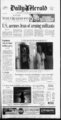
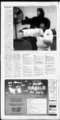
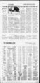
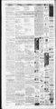
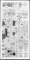
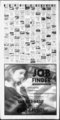
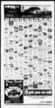
Show DAILY DC - - r"l WMfflER World cities Acapulco 8869 s Algiers Amsterdam 7052 pc 4844 r Ankara 4827 pc 6046 Athens Auckland c Baghdad 7245 s Bangkok Barbados 9375 pc 8475 s Beijing 5427 s Beirut 6551 r Belgrade 5446 pc Berlin 4236 sh 6360 pc Provo - Airport Salt Lake City Ogden HeberCity Orem - Utah Lake Spanish Fork Richfield Bogota Brussels c 4842 r Budapest Buenos Aires 5044 c 8468 s Cabo San 7955 s Cairo 6850 Calgary Cancun pc sn High: 68 at St. George Low: 24 at Wellington 8266 pc NATIONAL 8973 Caracas for the pc 7354 pc 4038 sh Dakar 8867 s 4639 sh 4236 r 6343 Geneva Grand Cayman Guadalajara Guam Hanoi s 8877 6146 5128 8261 s 2825 sn 8775 pc Lima 8071 c Lisbon 6354 r 5042 sh 5546 r 9170 pc 8873 pc Delhi Osaka Oslo Ottawa pc 8149 s 10 Panama City Paris Quebec pc t sh r pc sn 7 sf 9073 pc 5042 sh 16 City 0.44 5.15 4.97 0.13 0.16 0.77 6.06 8.79 FORK 2.90 5030 0.19 3.93 429 SPANISH ; to Sept. 30th J and tonight's lows. are today's highs spcy ft ' METON JS PAYSON 502 'GENOLA 50731) 2619 Atlantic 3612 mNTAQUIN rnru Austin 5144 ,tr Baltimore 3810 Billings 3723 Birmingham Bismarck 5725 Boise 5338 0.01 3119 Brownsville 6451 Buffalo 2414 0.02 262 Burlington Caribou Casper Charlotte 5434 5126 Chattanooga 5222 Cheyenne 5529 tr 264 5042 Dayton Denver 360 5029 3714 0.01 237 Moines Des LAKE CITY , .v.; VEGAS LARAMIE 9 3410 9 DENVER 4329! I COVE FORT ft PHOENIX 6748, : tions and continued scattered rain showers in the CEDAR CANYONLANDS' 5728 ft v.: 4623 5128 ' ESCALANTE ZlON ST. NP, 4928 52729. ' 242 . lower elevations. MOAB c Midland 5839 pc t Milwaukee 0.08 0.17 Minneapolis Mobile c New Orleans 6044 7258 c 3719 pc 5237 c 6030 r 2410 sn 3421 4026 4433 3521 Orlando 7147 Philadelphia Phoenix 3514 c Rapid Jacksonville 6432 Juneau 3015 Little 4315 City Rock Angeles Madison, tr 5236 Richmond 4516 r Recife 7465 pc de Janeiro 7669 pc 7257 pc Riyadh Rome Santiago Santo Domingo Seoul Shanghai Singapore Petersburg Thomas 85'74 Stockholm 2&'25 Sydney Tahiti pc 7366 sh 8777 c Taipei Tehran 7261 pc 5V37 s Tel Avtv 63J50 pc Tokyo 5V45 s Toronto 11 sf Trinidad 8874 pc Vancouver 48. 40 r Vienna 4744 c Warsaw 3534 sh Winnipeg Zurich 814 4638 5128 pc 5332 c 249 C Sacramento 6251 tr 5838 pc Salem, OR San Antonio 5243 0.20 5245 tr 6155 0.02 5853 0.04 6253 0.14 4835 7249 6253 5746 6045 8472 5026 0.01 0.12 5832 t pc pc pc S pc 7251 pc 6229 5445 r 5040 r 6450 t 3415 0.01 186 sn 3833 0.27 4126 c 3416 sn 4025 r 3820 i sn Spokane c Sprngfld, IL 4113 c Spmgfld, MO sn St. Louis 4219 tr 4625 s Syracuse Tallahassee 3017 tr 25 t 6429 0.01 7053 DC sn Tampa 7148 7563 r c Toledo, 2812 sf pc Tucson 6955 c Tulsa 4526 sn Waco pc Wash, r Wichita 263 OH 6748 s 5630 r 6745 t 4523 C 4020 r 6935 t 4826 c tr 5241 3717 DC 3822 5037 4435 3 Sf 0.12 256 tr 7757 3011 sn 7251 pc cloudy, flurries,sn-snow- , JWONTiaaO y-. . y 4525 ft , ' ' 5534 BLUFF . MEXICAN HAT 6032 KANAB 5629 ft ft 5331 7 cleansing rain storm moved Utah Valley Saturday night and It was also raining in the local mountains with the main snow level remaining above 7,000 feet. January was much drier than normal and until Sunday, the current month had been dry too. The flow was from a west southwest direction so upsloping on the local mountains enhanced moisture totals. Some precipitation totals as of 4pm Sunday included Sundance (7,500 feet) with 1.96 inches of water in 7 inches of snow and 1.30 inches of water on Timpanogos Divide (8,140 feet) with 9 inches of snow. In the valley, totals were .75 of an inch of rain in upper Cedar Hills, .38 on the Lehi Bench, .42 in northwest Pleasant Grove, .43 in Springville, .51' above UVSC, .42 in North Provo, .19 in Woodland Hills, .50 in northeast Orem and .18 in Saratoga Springs. DAVID JAMES answers your weather questions DIAMI SBHFRAIDTXIRA COM c r Ran Flumtil . -- 14 tJ,H mopwrwf 72M I i KKJ Feb. 12: In 1986, Ai What's up with the weather? IM0"rw'1 Weather history Springlike storm soaks the area pc s sn 0.01 3hwwn 5648 c 8555 s 8468 pc 4528 s 5748 s 8875 t 18.4 3215 sf 4423 r 3614 pc 304 c 4836 r 4420 r 6039 c 273 0.01 Rockford 5032 215 tr Wl c 7151 s 269 Reno 8771 3918 0.12 5020 City 5946 r Wichita Falls 6550 pc Yakima 4032 c Youngstown Yuma 229 5930 MS 0.17 6521 4726 6959 0.42 314 tr c 3922 0.02 297 tr 5542 c 7761 r 3516 4631 tr 0.01 265 3511 0.03 5645 7460 4535 Lexington 7865 Houston pc c 5443 r 6955 Honolulu r 5019 Vegas 0.01 r C 182 3715 2610 8167 7254 3618 6655 7455 2819 3417 6645 3521 f c 6133 San Juan 19-- W 5828 6042 pc Seattle 4829 r Shreveport 229 c Sioux City 236 338 Bay Harrisburg Helena 246 tr 259 tr 4 9 pc Santa Fe 4625 pc Savannah 0.07 tr HiLo 5233 5545 7569 7038 2413 Montgomery Nashville sn s 245 0.04 0.07 TODAY 7057 6649 c sf 2j v MT. CARMELJCT, GEORGE. 4 52728 - V 5026 - ft 7861 19-- Weather (W): ft jPANGUITCH PAROWAN 4929 6451 Grand Junction 5142 Los 5529 -- CmL . Miami Pr. 5124 ft State forecast 0.09 Louisville 5026 5027 ft 6242 5528 , ft JUNCTION IBEAVER LASCRUCES , RIVER s 6743 S San Diego 4636 r San Francisco 4030 sn San Jose 0.15 4632 Las " 5026 5 sf tr 3211 Memphis pc 136 tr Eargo pc 6640 t 3418 sn 3517 sn 229 sn 2610 Sf 4414 Fairbanks Kansas ARCHES 5428 HANKSVILLE f TUCSON '. 4221 I 5433 GREEN J 5329 ft . SEVIER 3WU f ALBUQUERQUE 7151 "JUNCTION 5026 9 " "CRESCENT" JUNCTION ft 5142 Jackson, FREMONT RICHFIELD Eugene Evansville Indianapolis 4724 TF 6946 Green PRICE SAUNA J420 I " rc 3vmm FLAGSTAFF Times of sun and clouds today. A shower early tonight, then a snow shower mainly in the higher eleva- 4522 MANT1 ft 5028 Paso Grand Rapids Great Falls DUCHESNE EPHRAIM ' 161 Flagstaff Fresno '4521 - ft 4724 IfILLMORE 5028, ft DURANGO ft 4625 w 4825 r, f ft I ,. (ft 3517 5 f DELTA - HELPER 3816 ', NEPHI 3215 ft- ft 4321" SOLDIER. ft - 4720 ft FRUITLANDt 4423 CHEYLfNE W . 3915 '!..!, w 9 J ft J 4222 ft ROOSEVELT 4524 SUMMIT ASPEN I inreruhnr " ABOVE EUREKA CASPER 4622 ' "VERNAL SE 5125 4523 , DINOSAUR " Duluth El 4618 CITY HEBERCITY - i? DETAIL?. ; ELY GORGE 3819 9' 339 fwAMCTnwfll f PARK -- ' lAcnu FLAMING 4422 k a COALVILLE Medford, 23 291 Dallas OR HiLo 5243 c 339 sn 6040 pc Pittsburgh 5844 c Pocatello 3215 sn Providence 2615 sf Prtlnd. ME 6953 pc Prtlnd, OR 3823 sn Pueblo 2813 sn Raleigh 300 256 310 ' YESTERDAY CITY W 4930 c New York 3413 pc Norfolk 7859 pc Okla. City 242 sf Omaha 5931 SC Concord 4324 tr Boston Cleveland MORGAN 0.01 HiLo 260 5433 2517 6148 4020 7046 4322 193 6155 1611 Cincinnati BRIGHAM CITY tr 5727 City Chicago Chlston. AOGAN i Anchorage Atlanta TODAY 4 sf 6849 St 0.40 4225 FALLS 6642 4 sf Quito St 0.38 48ua" OREM 4930 cloudy 4438 sh Prague Rio CITY 4927 168 pc Nice , 8574 8657 7770 6855 5845 5434 2015 Nassau 7.06 TOOELE POCATEa6 4636 r 8577 pc 7960 s Nairobi New CARSON 7863 pc 7550 s Moscow 4.02 4728 ELXO 6645 Madrid 17 0.69 S , 3821 m 347 -- , LAS London Bay 0.65 OGDEN 3920 4924 , - Kingston Monterrey Montreal 0.60 4120 s Kiev Montego 6.17 v- V ;f TREMONTON FALLS 4624 Karachi City 6.05 4.66 4931 4527 irrA iaammcmi Jakarta Milan 4.01 0.47 4019 IDAHO TWIN RENO Mexico 0.48 0.59 SALT 4930 5846 Melbourne 0.23 0.47 " provo 'Jm VV --- 0 0.20 - BOISE sn r 4929 v 5.42 4616 Hong Kong Istanbul 3425 Zoxuff 0.30 ft I 4128 ( 7349 " AMERICAN 4524 1.80 today's weather. Temperatures is SUNDANCE 0.47 0.01 317 554' 0.07 Albany ? 8.37 0.01 Hilo Pr. Detroit 7366 Martinique Mazatlan 4222 4113 4323 4223 4619 YESTERDAY Albuquerque 9 47 26 Mostly Across the U.S. TALPINtV 5.32 0.15 possible CITY 0.77 SA&V10N 7739 7965 Managua Manila 4224 Normal showers HUMiMilUfll'l HIGHLAND 42 24 Clouds and sun, snow 23 0.51 4831 pc 2318 Johannesburg Kabul 0.46 WENDOVER 8573 Helsinki Jerusalem 4525 4322 COEUR D'ALENE c Havana 26 Season Normal To Date To Date February High: 80 at Death Valley, CA Low: 18 at Bottineau, ND 8475 326 8168 Halifax Month To Date contiguous states. 48 8576 t 4340 r 4638 r Frankfurt 28 IJ Periods of clouds and Cloudy FRIDAY THURSDAY n '4929 pc 2M8 Fiji AQ Mostly cloudy (SZ3E3ED UTAH Copenhagen Damascus Edinburgh Edmonton m WEDNESDAY mil Yesterday Precip. HighLow Shown Extremes Casablanca Dublin c Rainfall year: Oct. 1st 7047 Lucas Normal 5041 4537 4839 4537 4534 4838 5040 5038 Provo-BY- 7057 sh Bermuda TUESDAY "' " 111 Will mm in .nil TODAY Regional almanac Yesterday HighLow Monday, February 12. 2007 r " Utah & The West TODAY HiLo W CITY HERALD nearly 3 feet of snow fell at Sundance, resulting in an avalanche National forecast duced 4 to 5 inches of rain in the mountains around St. George. Also, an avalanche in the La Sal Mountains killed 4 people. A strengthening storm over the middle part of the country will bring a swath of snow from Montana and the northern Rockies to the northern and central Plains today. Thunderstorms will rumble through Texas. which destroyed a home, leaving only the pillars standing. In 1992, a huge storm pro- Sun & moon o o ? New First quarter Full Feb. 17 Feb. 24 Mar. 3 Last quarter Mar. 11 IMi'.MJH,') RISES SUN 7:24 a.m. MOON 3:45 a.m. SETS 5:58 12 pm. 28pm. RISES 7:23 am. 4:45 a.m. SETS 5:59 p.m. 1:26 p.m. Sky watch Tonight' i Sky: This is the time of year when the Big Dipper stands on its handle in the NE during evening. Its top two stars point left toward Polaris, due VENUS north. SouM Inn Todd, Orfgon wd Industry MERCURY MARS MiMim ol Scww JUPITER SATURN RISES 7:57 m SETS 7:23 pm. 835 am. 543 a.m. 3:13 am, 539 pm, p.m. 3:04 p.m. 12 40 pm. 7:34 tm. End of snow squalls in sight for N.Y. John Kekis ASSOC lATfO PflfSS WRITfR before drifting back to the south again, said meteorologist Steve McLaughlin at the National Weather Service in Buffalo. "We have a sharp front coming in Monday that's going to kick all this out. We may get one more burst of snow, but then it's over. Finally, some mercy," McLaughlin said. Residents of the nearby town of Mexico see 5- - to snowfalls every two or three years, but this time even hardened locals are amazed. The only signs of parked SUVs are their radio antennas or roof racks sticking up above the snow. Front doors are buried and footprints lead The snow PARISH, N.Y. got even deeper Sunday but the end was in sight after a weeklong series of squalls that have buried towns on one corner of Lake Ontario. By early Sunday, the persistent streams of squalls fueled by moisture from the lakehad piled snow 1 15 inches deep at the Oswego County town of Parish, about 25 miles northeast of Syracuse. But as efforts to dig out Parish and surrounding towns was ramping up, the weather system was winding down. The squalls shifted northward to the Watertown to area Sunday morning, and were expected to die down Sidewalks that have been dug out look like Miniature can second-stor- windows. yons. The state transportation department said 125 workers from elsewhere in the state had been sent in with snow equipment to help. The region is located along the Tug Hill Plateau, the snowiest region this side of the Rocky Mountains. It's a wedge of land that rises 2.100 feet from the eastern shore of Lake Ontario. It usually gets about 300 inches of snow roughly 25 feet a year. The hamlet of Hooker, near the boundaries of Jefferson, Lewis, and Oswego counties, holds the state's one-yerecord with 466.9 inches, about 39 feet, fn the winter of ar 1976-7- 7. Less than a month ago it seemed more like spring. V i "Gosh, three weeks ago there was green on the ground. We got spoiled," Parish Mayor Leon Heagle said. "This just came fast. This is not normal God, we cant catch a break. I feel like getting right in the car and driving south, but I'd probably get in trouble." The intense blast of snow hasn't been blamed for any deaths in Oswego County. Elsewhere, however, more than a week of bitter cold and slippery roads have contributed to at least 25 deaths across the northeastern quarter of the nation five in Oliio, four in Illinois, four in Indiana, two in Kentucky, seven in Michigan, and one each in Wisconsin, and Maryland and elsewhere in New York, authorities said. DAVID Dvt Chast DUPfEYAoc.eted left and Ken Caps (raw clear snow from Parish, N.Y. on Saturday. a roof Prrat in |