| OCR Text |
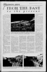
Show THE SAN JUAN RECORD Wednesday, April 19, 2000 - Page 5 LOd'Z'R lOO'K FROM THF PAST t o t k e p t e s e n t retiree Evan Lowry, and BLM retirees Bob Turri, Pete Steele, and Hindiey. (continued from page 1) vationist. Hindiey said that he wanted to be involved in a project such as this for a long time and was grateful that San Juan County gave him Scherick said that the county has used the cumulative expertise of the retired federal land managers to great effect. The experience and the chance. Hindiey states that the use of before and after photogra- field knowledge that they pos- phy has been used in several recent scientific projects in Utah. In all but one, the evidence shows that the land which has been managed for traditional uses is in better shape now than it was in the past. The study with a different outcome was completed in Yellowstone National Park, where the impact of hordes of tourists is unmistakable. Historical photos were collected from several sources, including university collections, the National Archives, US Geological Survey, Utah In marked contrast to the earlier photo, this current photograph within the Indian Creek drainage on State and San Juan County the Manti LaSal National Forest shows a significant increase in plant density and ground cover. The historical societies, BLM, For- gully system has been repaired. In addition, there are healthy stands of trees. If you are skeptical est Service, and the personal that it is the same location, check the trees and the road running through the photo. Earl Hindiey photo collection of Kent Frost of Monticello. Hindiey had the enviable task of traveling throughout San Juan County over the past two years and finding the exact location of the early photographs. Using a variety of lenses, Hindiey was able to duplicate the previous scene as much as possible. Interestingly, in a number of the repeat shots, Hindiey had to move one direction or the other due to the growth of vegetation since the early photograph. Officials state that the report counters the perception that grazing by domestic animals continues to cause wide- spread damage to federal lands. The study acknowlsevere that edges deteriorization of vegetation and watersheds occurred in the late 1800s, primarily be cause of drought cycles and Service employee who is working on the project, said, This study shows that livestock operators, federal land managers overgrazing. The report states that in recent years, vegetation conditions have greatly improved, and range management prothat soils are much more stable fessionals deserve recognition as the result of the presence of and credit for a record of sucprotecting vegetation, that cessful range management habitats that showed stable and steadily improving range state characteristics in early conditions. They have accomplished photographs have shown little change over time, and that ex- this stewardship without No otic plants (such as cheatgrass TVespassing signs. Now there and tamarisk) are becoming are those, including many in the federal land management more common. out that many Hindiey points agencies, who would have us believe that believe that we can no longer range scientists American rangelands are in the manage or care for the land best condition they have been without No Trespassing signs in this century and that, on av- or in other words, locking it up erage, they are improving. He to all but a few selected concludes that conditions are ' groups. far from being as dire as some This comparative photowould present. graph study is a part of a maForest retired Evan Lowry, a jor effort by San Juan County Cow Canyon in 1 925, as photographed by the U.S. Geological Surv ey. The stream bed is mostly barren, testament of the power of flash floods. Notice the down the canyon. branch in the cottonwood tree mid-wa- y sess provides a knowledge base that was needed to complete projects of this nature, said Scherick. The strength of the tfeam is the varied backgrounds of the members of the team." Scherick points out that Dr. Jim Bowns has also been heavily involved in the projects. Bowns, a range ecologist, will retire soon after a successful research and teaching career at Southern Utah University in Cedar City, Utah. Bowns has served as a technical advisor to the county. Other projects that the county has completed include the mapping of county roads through the use of sophisticated Global Positioning Systo fight the designation of tem satellites. The result is large areas of the county as the most comprehensive set of wilderness. The effort is be- maps ever developed in San ing directed by County Plan- Juan County. The mapping ner Ed Scherick and has made project is closely tied to a phouse of many county depart- tographic project which documents, including the planning, mented more than 16,000 road, survey, assessor, and in- instances where man has had formation technology departan impact on the land. ments. The satellite and photoA large number of retired graphic studies were used by federal land use managers the county to create a response also have been involved. In to the BLM proposal to desigfact, five of the workers have nate additional Wilderness more than 150 years offederal Study Areas in San Juan government experience be- In addition, the county used the studies to develop an additional critique of the BLM wilderness inventory County. tween them. Scherick himself served for 30 years in the BLM, including more than 14 years as the Area Manager of entitled Politically Motithe San Juan Resource Area vated, Technically Flawed. Over the next several weeks, of the BLM. Other retired land use man- the San Juan Record will pubagers who have worked on the lish a series of the before and projects include Forest Service after shots. The biggest change in 1 999 is obviously the presence of US Highway 191 mak- Bluff. its ing However, notice the significant increase in cottonwood, way to willow and reed since 1 925. The cottonwood is going strong. |