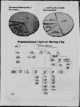
| Show LEGALS (rom TION: radius t - 3B Page April Col 16 the 5) 1981 said along 251605 W 39’40’58” f NOTICK curve thence N ft 398266 W 20’27’41” ft NOTICE O PUBLIC HEARING ft ZONING f ft MURRAY CITY UTAH: PARTIES AND f t INTEREST PERSONS OWNING ft PRO-PERTY OR f THE LIMITS CITY CORPORATE MURRAY O LAKE STATE O COUNTY UTAH NOTICE GIVEN Tuesday 1981 the at said South thence to Murray will hold conduct a Hearing on and pertaining to Murray City wherein that following proposed is areas City State rezoned to zone from R-l-8 Beginning at feet and West 2870656 14 N 1 Range Salt Lake Meridian West & Base thence North West 99 feet feet 9294 East East 3’21’36” more the to f (Approximately South code and the the which Halcyon zone upon map within said along mentioned ft hearing will 14974 84’49’56” be at the office the of Drive MURRAY 29917 Corner curve the NE O Riverbend 84 UTAH thence P Date 12’02’ W Pierson ft Recorder City Publication: of April and 16 1981 N 195238 side Utah ORDINANCE N 855768 ft point NO THE to Its first A the O AS UTAH Murray City REZONED ZONE at 1’15’ E DATE e PUBLIC NOTICE PUBLIC the left center 33’47’09” Riverside ON COMMISSIONERS O MURRAY E 9 point of a ft to curvature 60361 the annexation reviewed the at upon office Recorder City 5461 hold 16 23 THE ON INTO of P O MURRAY AND Commissioners to the will the Mr of This O COMMISSIONERS O MURRAY INTO PROPOSED O ZONING O CITY from South 250 C-S-C and a The the PARTIES IN AND PERTY OR IN WITHIN O ALL CITY INTEREST PARTIES OWNING INTERESTED OR PROPERTY CORPORATE THE O LIMITS MURRAY CITY IN WITHIN ALL IN AND ' M25-4B a 30423 41635 from the INTEREST O PERSONS INTO PROPERTY CITY AND INTERESTED PROPERTY CORPORATE THE O LIMITS MURRAY CITY ANNEXATION PROPERTY MURRAY BOUNDARIES PROPOSED AMENDMENT O ZONING O CITY ORDINANCE 3528 South ALL 2 South 25895 South 25 East thence feet thence North thence Street feet 6275 MURRAY BOUNDARIES AND O ZONING the ORDINANCE MURRAY O CITY Acres UTAH: PARTIES ALL INTEREST IN AND AND PERSONS OWNING Rods 14411 Meridian North running along said noaccess feet line the following South 87’31’26” feet East thence 81’42’59” feet East the 300 thence East centerline East along 3026 North West 358 UTAH COUNTY Meridian feet West feet 50722 feet to May hour of day GIVEN hour of Resolution the for the Utah City annexation Ordinance and amending proposed the of code of the in Chambers 5461 South Murray Board Murray the together with proposed annexation 6:00 hold 1981 pm at on the of City State Hall Street the Commissioners Murray City will conduct a hearing on and public and Street CITY 12700 feet Murray of hold conduct a hearing on and to the annexation of into and amendment of Zoning the tion of said North the to pertaining You per TO AREA said feet 16990 point begin of Uniform to further are that an there this use public use is notified intent no for property in the future of THE r property of lies BOARD O 1 COMMISSIONERS O MURRAY CITY UTAH (Approximately ROM line the below: South 78’06’15” ning descrip-: proposals 4800 along North public parcel legal said of East Ordinance same The the North Street as dedicated thence will on of the to South property City Murray the angle 7’16’38” proposed boundaries feet line along curve through a central the and thence said of arc 8256 Hall City West feet Northwesterly Commissioners of point a the the Street Utah Murray Board line to 47’08’50” said City State along a of the at South the to curve radius point South which is on left Tuesday on dedicated as South 1981 of 4800 said Commission South the of 77’59’ pm the to O said Commission Utah of of Thursday on 21 South HEREBY 12 Chambers 5461 for HEREBY IS that May day of PUBLIC: NOTICE the line a of angle thence West on 6:00 in land of beginning Contains 392 Acres Copies CITY SALT GENERAL 27722 feet Rods East O IS that CORPORATE LAKE O STATE CITIZENS AND UTAH 56044 point thence 89’47’25” SL THE LIMITS MURRAY T2S 24 Section South PUBLIC: NOTICE GIVEN PROPERTY WITHIN West from southeast comer and East thence IN and feet the R1W courses: North PROPERTY CORPORATE line through PERSONS INTERESTED curve West central 17’14’38” 65000 PROPERTY INTERESTED OR 442 said feet 6802 INTEREST THE GENERAL PROPOSED AMENDMENT East ALL UTAH SALT LAKE STATE O COUNTY UTAH CITIZENS AND ANNEXATION INTO 41944 COMMENCING said PROPERTY CITY beginning of O HEARING O feet to of and MURRAY PROPOSED feet East 320 230 of West 14100 39000 ON thence thence and' to 3026 feet North NOTICE feet thence arc -LIMITS of South West 66’08’52” PROPERTY WITHIN point is ORDINANCE OR NOTICK PUBLIC radius a on right the to MURRAY AND beginning feet thence 22600 Southerly along the PROPOSED IN IN thence of being which BOUNDARIES OWNING M25-4B PUBLIC the PROPERTY UTAH: 23 16 Meridian point curve AMENDMENT PUBLICATION: of 8 and said MURRAY ZONING feet center 1 ANNEXATION AND CITY 1981 30 the Base CITY feet Township 2 South Range East Salt Lake O INTO of being 174569 West 67538 and HEARING O South 23000 North thence Salt feet feet 19 South 81’42’59” 9900 MURRAY UTAH: feet 12000 feet East four South PROPOSED 16590 West and M East point North 23 PROPOSED thence running as is Base O & 16 NOTICK THE 9 900 of also 415-97 Section Township Range PUBLIC HEARING ON PUBLIC O O point a right-of-way said Section MURRAY April at West from COMMIS DATE is ds follows: the of Pierson Recorder T2S Murray beginning M25-4B PARTIES corner 24 SLB feet 9 1981 30 Ludell P City at property line PUBLICATION: April and a is Southeast Section Contains and of thence NOTICE 128110 O the day O O a known No West center of at North feet and West feet from the 132000 point and South NOTICK MURRAY UTAH: PERSONS PRO- following Southerly point Lake ORDINANCE which 28320 at line feet 23 PROPOSED ZONING MURRAY an description: the PUBLICATION: PUBLIC point 42480 to BEGINNING on BOARD ease-ments 4800 East said on O R-l-8 BEGINNING thence unzoned has property AN 900 described MURRAY (as 2nd ORDER SIONERS the classification R-M-12 which 1981 DATE ON CITY South East classification Project MURRAY AMENDMENT O 30 in property 1981 BY utility all Street NOTICE this old of Road to Utah COMMISSIONERS Annotated Dated UNZONED vacation approximately intent alleyway use the hold UTAH REZONED AN TO AREA for property 1 BOUNDARIES AND ORDINANCE UTAH: and ANNEXATION CITY PUBLIC ZONE application approximately at 6700 BE ROM R1W of following freeway Pierson 16 BOARD of will located Utah O 6850 Jefferson) TO and reclassification point 9 public and April concern Barton UTAH O THE Board notified 1953 South subject South to pursuant provisions of Section Utah Code 10-8-85 the to revert the the feet Recorder DATE for will City State O jthe Utah Murray-Holladay of Ludell P Pierson City Recorder not is this use future description (Approximately appeal Barton with located City conduct a Hearing and on appeal itself City State State PROPERTY CITY AMENDMENT the and pertaining Mr Ray feet HEARING legal Murray 0195 there to of Utah legal O PROPOSED BOUNDARIES in Utah BOARD Ludell NOTICK PUBLIC ANNEXATION the Murray of City South Murray M25-4B 1981 PROPERTY OWNING curve thence N 13943 of the Hall NOTICE O Northeasterly said be may at South ' O PROPOSED thence ft will the which upon within hearing mentioned will be conducted April radius to with Street South Hall Street and conduct Public a Hearing and pertaining on City Recorder 5461 beginning further are that an parcel City Hall City Coinmissioners Murray hearing office the said of Stdte Beginning You Ordinance same the at 21st at Commission of South of conducted reviewed upon be the pm the Murray the annexation which the be request feet (Contains Uniform property of lies be proposals said PUBLICATION: PUBLIC HEARING a (whose the NOTICK CITY on code Murray proposed City M N bears W) on 29’10’ Utah the of on with 5:30 in 5461 Murray HEREBY on 1981 Chambers of acres) City the of of upon within mentioned property and The of code IS April of day Ordinance the will O HEARING that of hour annexation together may day proposed for plat 27416 South 200 point pertaining Murray the the to public NOTICE PUBLIC to beginn the City the West low: Commission Murray Board of the 1574 together Utah pm no-access Power point Street to Ordinance CITY right-of-way ft 209815 State Pierson April and 30 the 14000 South thence 17’30’ proposed of boundaries land Chambers ofthe City O 1981 5461 beginning of 28 City Public amending the West East of proposed of 23 NOTICK NOTICE Utah 16 M25-4B PUBLIC 640 less of and 1967 thence feet will conduct a hearing on and amendment Tuesday right-of-way 2S & Street and UTAH O 16 M26-1B 23 City and into HEREBY on 5:30 of Hall Copies of the proposed Resolution for annexation Recorder DATE 16 M25-4B that Murray Acres of Corner 316768 ft line West Drive PUBLICATION: 1981 hour feet Contains City Murray of NOTICK of Street O of centerline East point thence Utah Light 44446 ft T the a City April and 11 the along the Commissioners of to 9 IS April 0’19’30” said 900 North SLB curve CITY P Board PUBLICATION: NOTICE the South BOARD Ludell MURRAY 1981 30 GIVEN plat Ludell P Pierson Recorder point a is Sec to of hearing office Murray ATTEST: O point South South 62’55’ the or amending thence 17’15’ feet East more the 9 North feet Resolution ? PUBLICATION: 1981 30 GIVEN feet East feet and 3300 West 89’50’30” Block comer 62’55’ said of thence Copies thence O April running 29374 North 1 DATE to ing 12905 Northeast Northeast Street Utah feet Street Lake 24 Pierson Recorder North 00’09’30” thence 17’15’ East 16007 feet to the lot City North lot P Ludell Right-of-Way South the Utah thence thence 7 State South Murray COM BOARD O MURRAY MISSIONERS O CITY UTAH 89’51’ southerly amended) 6393 18760 the Recorder 5461 THE Murray NOTICE O PUBLIC HEARING Street South along of Muir Mayor COMMISSIONERS of 24116 South center East request running and the at land of ft 1096563 West 2212526 the from SE of Hall D with the to West be conducted reviewed upon City Street ZONE along the O Section Salt 5461 of City THE the 170 feet upon office Recorder City Street Street feet 22 the existing North 4500 858 J Hall State from -Northerly de conducted point a South East with be at Hall of perpendicularly of thence Street Addition North 62’55’ West said City of South a North East thence annexation be O PUBLIC right thence 89’40’30” Murray which upon mentioned request day 1981 LaRell R-M-7 Beginning which N 9th code of will Chambers to centerline vacating and thence Commission the in feet less or the hearing reviewed request distant Northwest’ the to will be the which mentioned may the with of annexation upon to 182 code Murray of together within Cottonwood center Southerly legal of corner of Atwood the on creek 500 the 4 Tuesday at pm Zoning radius the East feet) to-wit: A R1W this on point of bears 83’04’15” Ordinance proposed may and feet arc to curve (Chord annexation together within day 1981 5:30 of 12319 foot 95493 proposed fhe City Utah upon ADOPTED following in R-l-8 and effect the I tract BE of Ordinance State hour 19 said 11937 Ordinance proposed pertaining Street R1E feet HEREBY on Northeasterly the feet for and THE BOARD COMMISSIONERS CITY MURRAY O O along Contains the of amending City UTAH April Utah plat feet Public a thence 17’30’ East CITY that annexation’ North 24180 thence West the to Resolution Murray NOTICE GIVEN May the 4500 Meridian CORPORATE THE O LIMITS IS more its feet beginning the ‘ City the located the T2S CITIZENS AND GENERAL PUBLIC: Ludell P Pierson City Recorder DATE the following quarter PROPERTY INTERESTED UTAH hold 5900 thence 900 the of Utah BOARD CITY said East feet West feet Copies THE Street Street 75’49’ thence beginning BY O South upon office Murray of and 85’30’ Northerly along will and on Crawford of UTAH SALT LAKE O COUNTY STATE 5461 and along of Centerline 2793 acres publication of April described TO of PASSED BY CITY SECTION ROM 86’11’20” health this take OLLOWS: TO 5872 South plat MURRAY area Utah 66’24’15” necessary that CITY THE BOARD COMMISSIONERS and is peace and safety inhabitants of O ORDAINED That North the Street thence West 16300 feet South Glenoaks Commissioners the Utah 5900 2’33’ the of 71601 thence feet 9580 Street 3659 INTEREST hearing South City conduct Clark PERSONS MURRAY of Recorder 5461 point amending existing of feet the East of the Southeast comer of the Northeast quarter PROPERTY WITHIN for E II opinion of it CERTAIN AREAS IT the In iCLAS-SIICATON MURRAY to West the thence North 122000 North feet 2500 North beginning of Board UTAH PERTAINING TO THE CHANGING O ZONING O and West thence of CITY CITY MURRAY O feet SECTION ORDINANCE AMENDING THE O 88’00’ the Hall North North 14’11’ West 4000 feet to the intersection of 5619 North thence of 1’15’ East feet 704 AN CODE W the feet) 39722 South thence 2510’ to Power thence West feet ft right-of-way Light NOTICK 88’00’ 10’20’18” 25342 City left bears North a radius the to curve (Chord South thence of arc foot 27284 1132 feet the the (Utah BEGINNING ALL IN IN conducted at the and 48829 Copies of the proposed Resolution for annexation Street center thence Hall feet MURRAY AND the reviewed request of line ORDINANCE UTAH: 4463 Murray be line acres Creek scription: PROPOSED PARTIES beginning of may Northwesterly 3662 South East feet thence along the CITY to which upon mentioned said Commissioners alley-way the BOUNDARIES O the Glenoaks of Street limit Contains 68 20278 the Street Murray an West the of State of near and PROPERTY at City of and of MURRAY ZONING North be to West North Thursday on along Murray West East thence AMENDMENT O Ordinance will North more or less to Right-of-way Westerly the North West extension thence line pm Hearing ANNEXATION AND code within feet Commission South hold O INTO the plat 7531 center the to line North West the HEARING O Utah together with the proposed' annexation left bears feet) Subdivision thence the in to amending City day Board PROPOSED ON a radius to corner East of arc foot 78’42’02” feet of East 14’40’ S 81’ 19 the curve (Chord feet thence feet W 3500 ft M26-2B PUBLIC lot feet ‘C’ thence thence West 23 3762 85’08’ lot 1’15’ S 43299 said Subdlvi-’ 57’32’30” Subdivision Plat along 70000 NOTICE PUBLIC Copies of the proposed Resolution for annexation and 5:30 of OWNING feet 7535 of Chambers NOTICE OR Northwesterly 14713 feet GEN 1981 Murray PUBLIC East of City Northwesterly HEREBY 7 hour 5461 Acres 5849 16 M25-2B North West thence and 9 1981 0’04’ Contains 3300 PUBLICATION: CITY 1750’ point 74’30’00” 106597 existing North 20824 thence South line thence the thence feet 59063 365 NOTICE IS GIVEN that 10 thence East North DATE O 62600’ 89’42’ 0’04’ the Recorder East South thence AND 0’09’30” along Murray limit North 23’03’07” North South West City feet the property existing 50487 of of County Sanitary the 65426 West thence ERALPUBLIC: Pierson City ield West Southwood East feet 9 South 46720’ thence feet UTAH 89’42’ 37518’ feet 22’27’51” COUNTY O CITIZENS West IN-TERESTED CI-TY STATE thence 45’00’ line North 89’50’30” West 12033 point a thence running thence to District Meridian South feet LIMITS LAKE and ex- City Extension Lake Cottonwood Salt East Centerline said ‘Salt 6 line said feet the the South 2 87’11’10” PROPERTY WITHIN CORPORATE O MURRAY UTAH SALT 250 East) P West North West West North West thence 75’37’ 0’04’ thence Section of Murray Murray 48728 on being 0’09’30” along isting the 500 limit and West from Base feet OWNING THE May thence North feet also South a a on said existing thence South is and IN 6700 at and feet thence AND OR the City ZONE P-0 which Lake BETWEEN INTEREST PERSONS PROPERTY O THE ORDER BOARD O MURRAY CITY COMMISSION ERS 10000’ 15768’ EAST TO IN the to April North thence Subdivision Huf-faker of thence to of 14’23’ South thence 21800’ AN beginning of Ludell thence AN TO A Quarter Township Range ALLEY-WAY to Street Centerline on of comer the Quarter Northwest of the Southeast VACATING feet being Southeast East 89’42’ to thence 4 6 East (Approximately East South 89’42’ East (Chord to point 6913 19180’ 10000’ thence along 75’37’ feet East section 106597 West 404 Northeast AVENUE AND CLARK STREET ON THE SOUTH: ALL PARTIES running North 0’04’ 5920’ 37300 feet) South thence 35891 thence said line REZONED UNZONED BE 39986 CRAWORD and East 8378 a feet Boundary South thence 10 of line Huffaker a ft Lot the 0’04’ North 88’ feet West Survey East curve No &00 East 5012 Southwest of right North Subdivision East along the the feet plat East radius 798 89’42’ South feet feet existing Corner of Block Acre Plat A Big Westerly of arc (bears and from a point 98580’ of at 0’04’ 3300 900 and be lies BEGINNING RUNNING WEST East 81’42’59” C-D-C City North M West 15998 Southwest of thence curve to the left thence Westerly along said CITY Ludell of a South Huffaker to thence South at A said existing thence distance arc East South of feet UNZONED the on Murray North thence 16123 left 6521 the ft 137199 O BOARD COMMISSIONERS point of point the & said of the feet sions 97933 thence South 3’57’30” Halcyon the below: Street) BEGINNING thence 79’37’ radius an to the 294636 curvature City Recorder Hall South State Street Murray Utah 5461 THE W to on of Section R1W 89’53’45” along of South) 4500 231 PROPOSED following courses: 87’25’37” East North East HEARING O no-access three REZONEDi AN TO ON BY and East West Street curve with a of angle a thence curve S thence along ft City right the Northwest of SLB&M of 16 O NOTICE ZONE Right-of-way feet State BE AREA from the to line South East thence West 900 the to a Drive Westerly thence conducted be may reviewed upon request BE the to curve Utah on feet Northeasterly Amended radius the TO said SLB 89’40’30” line 52005 foot corner ft 409133 City R1E North thence ‘C’ line of the comer T2S 1 along 30660 County Monument the Centerline of 1 description (Approximately intersection Comer 17T2S section 8300 point a 73’46’41” feet parcel legal 9 M25-4B NOTICK thence said from description proposals ROM AREA PUB-LICATION: April aforesaid along parcel property the TO 1981 30 PUBLIC no-access freeway Ordinance property proposals lies 4300 South feet running Of East of 64 point a amending the of district also to Subdivision Plat with together use Riverbend proposed Murray of lot of Uniform said right-of-way of feet an low: East O PUBLIC the to and section Ordinance legal North line the Uniform the same The point North feet line MURRAY 480 thence Southerly an the same of beginning Southwest along line 2’40’11” NE the on of The South 0’19’30” 107963 Murray Street central N the land East feet North Street thence curve thence along N and from being 173134 boundary West 139940 15858 to Corner Bullion) Copies of the Ordinance the ft existing 509 W 86’38’16” 558773 ft thence N 29’ W 48872 the feet thence t point beginning 5700 E for Street 89’34’47” running West East SW thence 0’37’ the East 8713 property City Murray boundaries ROM 900 6005 of also North West 18’53’30” Subdivision proposed a the at (Vine point of Ninth Ninth East W Village feet thence South West 90 feet the thence ‘E’ annexation of 23561 county running East 900 East Street) East and City line lot the South a and Street and North East 5420 County a the to from Street being in is West of Meridian point Street and 11105 of Plat of 13’20’ the to C-N at which Monument is Salt thence W Majestic 83’44’ S feet East S to of below: feet COMMISSIONERS O feet South 89’47’53” pertaining and 23 thence 22210 thence public and on amendment A will and the land on which East 89’53’45” UTAH DATE West feet North City 15253 thence 1400 Commissioners hearing 900 the City Murray conduct a of said feet South also Monument W 86’38’16” ft said 86’11’20” feet from feet Utah amendment of for P Pierson Recorder Ludell feet West and (Approximately North 75’00’00” feet CITY West thence boundaries 4g is point City Murray 1981 16 Apr proposed property Zoning O BOARD THE thence 5985 the City State South Murray Utah 4750 feet of into 5461 feet thence the of Recorder Street to annexation taining upon office Thursday Sheet following South 11000 Green of 16368 South Street Hall courses: feet the Hall State of hold of City of Murray Board at City the said of the at No the thence pm on Commission South description TO 0’19’30” from ’8’53’30” 37301 34’21’ ft 14320 150787 Corner thence 121 less W AREA Section of and thence thence N center 71’06’30” 22’ ft 88’01’10” ft 84’20’ 0’37’ North or 2 S the 5461 REZONED UNZONED and feet Township 2 Range East Lake Base and 6760 N ft 34721 W 5726 Section of Township South of thence ft East the ft E legal BE AN ROM point feet 73055 said 65’ parcel the property lies proposals a which 8 left feet the from Corner S in Ordinance (Approximately line 376 North 390954 curve thence day line six said Chambers ZONE at point beginning along North a S Southeasterly point a at right the to curve thence zone a 811719 90757 A-5 an Ninth West curve radius ft 5:30 Uniform of said of an the same The of below: East East Street on North Southerly said of land R-M-12 the radius the to along Utah of 13000 a curve thence Lake Salt County on described Murray in ft amendment on along feet point a and 1981 21 hour City on Zoning ANi TO of curve to boundaries the May public pertaining Murray Zoning REZONED UNZONED AN point E) said ft the Acres thence subdivision Thursday 21 Diamond reviewed request the Northerly HEREBY IS that GIVEN East 5900 South) 1 along of 4970 BEGINNING Southeasterly 193116 will proposed property BEGINNING ft bears of Utah it the center annexation for East) BE ROM AREA ZONE 23000 a right thence Ordinance Zoning TO to curve (whose 23’06’27” the to on 900 South S 1006 radius the proposed a amendment be ft and Public point a City the property lies proposals (Approximately 5994 E Uniform S E 23’06’27” Commissioners the the NOTICE Lot be may Northeast of West into S thence the an of 314938 23’06’27” on to into Ordinance parcel of same The legal description said W thence ft City City 11373 PUBLIC: GENERAL ‘Commissioners South the to 1 the and conduct a hearing and on pertaining the land Utah of TO 50’ W hold Hall Street Murray of ft thence 66’53’33” 5461 Utah of of 40624 S ft ft Street of ’E Board Zoning S 17485 31 the in State Board S Murray public Murray amendment for 5:30 Hall Murray E ft Chambers City 16’30’ thence South will MURRAY feet comer CITY SALT UTAH LAKE STATE O COUNTY UTAH CITIZENS AND Commission City feet O LIMITS said on THE 38998 The which the upon hearing mentioned will be conducted plat thence within thence CORPORATE West feet 2457 West PROPERTY IN WITHIN the at pm State the property and 5 41585 day pm on Commission of that of the S 40557 ft thence 71’43’10” E 79315 ft to the NE Corner of lot 8 of Clover 3 Crest Subdivision IS May hour thence thence HEREBY of the proposed boundaries 53944 N CITIZENS PUBLIC: annexation E GENERAL AND S E 33’06’30” 488912 ft thence N 34’37’ SALT UTAH on ft the into 9020 E 33’27’54” WITHIN S thence t PROPERTY IN E 39’30’20” INTERESTED to 5:30 5461 Street City of in of Commissioners of 4550 thence State hour day Chambers Hall and conduct a hearing on and N E 37’05’15” hold 6445 City of Murray of said on pm on 1981 PROPERTY 0’12’35” EAGLE MUKKAY(UT) centerline South INTER OR Tuesday said PERSONS OWNING HEREBY 12 May the at IS INTEREST AND ESTED that IN PARTIES PUBLIC- NOTICE GIVEN Tuesday Utah Board GENERAL Commission the South N E 1981 Murray 3702 thence 19 6:00 in 5461 N E on Chambers 4191 thence 53’36’09” ALL IN E of day N thence 70’07’02” ORDINANCE O t hour 4630 thence SALT LAKE COUNTY STATE O UTAH CITIZENS AND HEREBY IS that May N E 81’48’47” ON PROPOSED AMENDMENT O GIVEN 5151 thence 38’08’12” NOTICE N thence t UTAH SALT LAKE STATE O UTAH CITIZENS AND GENERAL PUBLIC: COUNTY Northeasterly M26-1B PUBLIC UTAH curve to thence left: 500 4150 Ludell West) BE City AN REZONED UNZONED TO AN M-G-C DATE ZONE April 1981 BEGINNING at O a 2 April Pierson Recorder PUBLICA-' March TION: P 1981 16 26 1981 April 1981 M23-4B 9 |