| OCR Text |
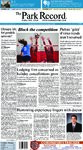
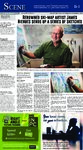
Show B-4 S M A C K L A U R A The Park Record E N D I N P O I N T B D E B A V A R S E C O H U S P E X E E L T R O J H U R O E R E F L E L O T E X T A V I A P E E R E N R A T R S E N C K L E M A R E G E N I E T N D G P W A W A R A N N N T A I E C T D O T L I R Y A T G E M M S M Y L A E H I S E P H A R I O B O N E L Y O F P B O L A I G E R T S A M S H A T E O B O D L E R E D O N O V E O A A T T H C A R S A L A A N S E I T E M S T A G R A R E N A R Y D U S T O S I S T E S W R A T R E H A K E E M M A D E R I E N N G T S R E A A L T E E N G A R D E S T L A A C I R R O S E R A P M M A I L E S T E N A W A P A N V S T I T I O L O L U C A E R A P S L I G L A I R E N O R A T W I T E D M L E S A G I T R E P A R T O T E T D E T O S A T E E N S E E D K H Z S A Y S O Sat/Sun/Mon/Tues, October 31-November 3, 2020 Continued from B-1 Ski map sketches released looking horizontally. With the lengthened runs the foreground gave the viewer the feeling that they were looking down on the mountain. Later in my career, to show multi-sided mountains in one view, I eliminated the horizon so it was very clear that the direction of view was more vertical than horizontal. This oblique perspective helped the viewer correctly interpret the steepness of the runs. COURTESY OF PALE MORNING MEDIA Ski map painter James Niehues has released a series of black-and-white sketches, which includes Park City Mountain Resort. P.R.: How do you decide which maps you are going to paint? Are they commissioned? Or do you find something fascinating in the terrain that you want to capture? J.N.: The ski industry is a relatively small industry for an artist to make a living. I took on every ski resort that I could attract and got signed on as a project, (and) I painted only the resorts that contract me to do so. Because this is seasonal work taking up my summer, by late November I was usually out of work. So I sought out summer scenes that I could paint in the winter, just as Hal and Bill had done before me. These projects were usually regional views for a Visitor Bureau or Chamber of Commerce for promoting the area’s recreational potential. My job was to show all the features in the most direct visual possible. A bird’s eye view is much easier for the viewer to understand the terrain’s variety and what they can expect to find in the region than a topographical map. P.R.: Other than your pencils, airbrushes and watercolors, what other items do you rely on in order to paint these maps, i.e. photographs, topographical maps, etc? J.N.: My tools and reference material to paint the actual painting is much the same today as when I first painted a map in 1987. Today the computer has made it easier to gather reference material, get approvals and provide the finished scan, but all else is still old school. I still work primarily from aerial photographs to get the correct detail and proper interpretation of the slopes. After the flight, I have the best perspective already formulated in my mind, (and) each piece is still composed and created by the thought process, and then sketched and painted by hand. The computer does not have the ability to manipulate the slopes to show all sides of the mountain, (but) there is no numerical formula. I utilize many unrelated variables and perspectives from many viewpoints to create one scene. Hand-painting assures a wider array of color, texture and tone representing nature better than using a computer. P.R.: What is the biggest recurring challenge you face when painting a ski map? J.N.: Without a doubt the biggest recurring challenge on a multi-sloped mountain is showing all slopes effectively and keeping them all in correct relativity so the skier can determine the true difficulty he might encounter at any given point. The most effective map is going to convey this to the viewer in an immediate and understandable manner. P.R.: What has been the most difficult map to paint to date? J.N.: I had been approaching Mt. Bachelor for years with a cleaner two-view approach, then finally in 2018 they called. When I took on the project I was entertaining the idea that it could be viewed in one view, all 360 degrees of skiing off of an extinct volcano. I had, in recent years, been very successful in showing difficult mountains by using a “satellite perspective.” Because the south side (of Mt. Bachelor) is open skiing instead of runs, the view would be effective even with the south slopes “skiing” up-page. Many angles were changed from the aerials to get all the front to line up correctly and through the use of color and shading, and it was clear to the viewer that they were looking down steep slopes when viewing the south side. But even more difficult was the latest version of Sun Peaks, Canada, produced in 2019. Because their village and base are in a valley with slopes on all sides, it was very tricky to show the proper length of lift and stretch the terrain so the lift bases were in proper relationship to each other while keeping a good angle of descent on the slopes. P.R.: What have been some of the unforeseen rewards of being able to paint these maps? J.N.: My career has been extremely rewarding. I try to paint the resort and its slopes with the skier in mind, more so than the resort’s, knowing that ultimately, I am L-R: Kelli, Richard, Aaron © 2020 Morgan Stanley Smith Barney LLC. Member SIPC. SUP031 CRC 2639259 08/19 P.R.: A couple of weeks ago you released a series of rare sketches that include Park City. Have you been thinking of releasing those for a while, and what does it mean to you as an artist to finally have these out in the public? J.N.: The sketches that are being offered right now on my site are the actual conceptual sketches that are approved by the resorts for the final painting. Sketches are the guts to a good successful trail map. It is where all the slopes on a multi-faceted mountain are manipulated into a coherent view that comes together onto a flat sheet of paper. These sketches stand alone as works of art, (and) I have some framed in my own studio and enjoy them as much as the final paintings. I am thrilled that these sketches are now available. Framed, they are excellent in Dens, Studies, studios, libraries, and offices. They are the essence of the final ski map. Local Park City news every Wednesday and Saturday When our community thrives, we all prosper. Prosperity is about so much more than money. It’s about living well in a community that is healthy and stable. At Morgan Stanley, we feel fortunate to live in a place that is supported by so many worthy service organizations. Their good deeds make everyone’s life richer. responsible for the skier’s ability to navigate the mountain. By the mid 1990’s I had painted enough trail maps to begin envisioning a coffee table book of my ski maps with history and how-to sections. I felt it would be very marketable in all resorts because of the rich history of this unique pocket guide. In March 2017 Todd Bennett (who cofounded Open Road Ski Company with Ben Farrow) emailed me asking if I had a book out and if not he would like to help me publish one. Making a long story short, in March 2019 the book came alive in a kickstarter campaign that became the all-time most supported venture in its category with 5,000 supporters. Open Road Ski, is extremely successful in marketing and delivering the goods. I thank all the supporters for their part in not only making this book a success, but just in the fact that they are skiers, the whole reason for trail maps. Then this last year I was nominated and voted into the National Ski and Snowboard Hall of Fame and the Colorado Snowsports Hall of Fame. I am very humbled and honored by this recognition. The Potashner Group at Morgan Stanley Richard Potashner Senior Vice President Financial Advisor richard.potashner@morganstanley.com Aaron Rokeach Financial Advisor aaron.rokeach@morganstanley.com Kelli Brown Senior Registered Client Associate kelli.brown@morganstanley.com 60 East South Temple, 20th Floor Salt Lake City, UT 84111 801-322-7683 • 800-733-9036 advisor.morganstanley.com/ the-potashner-group Call al 435-649-9014 -6 9-90 too su subscribe crib today! |