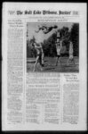
| Show Jt THE SALT LAKE TRIBUNE SUNDAY MORNINO OCTOBER 21 1934 FLOOD- - CHECK PROJECT NEARING COMPLETION r Davis County Breathing Easier as C C C Workers r Build Elaborate Pattern $$' of Terraces and Ditches H A - fc - is1® -v v f'A'fa 2 safeguard the lowlands from floods but rehabilitate the ranges so that when the vegetation again has grown grazing can be permitted if it is put under rigid - ?- ’ ' & control f Controlled grazing It was 'explained 2 joemst 1 Atr will' not destroy the vegetation It is only unregulated grazing and burning! of the brush which denudes the area In addition to ordinary brush fires tha ' firs damage has resulted also from the practice of sheepmen who set fire to the stocky chaparral so their animals could more easily reach the undergrass To C L Forslmg director of the forest and range expert-men- t jfc By HAMPTON C GODBE station is given much of the credit for the Davis county control program It was largely through his efforts that the present control program which strikes at the source of the floods rather than at controlling them after they have begun was evolved and carried' through Professor Bailey also assisted with the In the Davis county the fountain of devastating Hoods which the Rain Gods In recent years have sent coursing down upon the fertile valleys below the federal HIGH Work As stated government unique It is Jscompletinga construction a ing es I nates because of the large amount of experimental work going on in connection with the project One unofficial estimate however set the cost at $125 per mile of terracing But while estimates of the total cost of the project including the road are unavailable even if the expense far exceeded $100000 it still would be many times less than the damage caused by the 1930 floods The work not only will project project which promises to write another fascinating chapter in the history of man’s mastery over nature a project upon which are focused the eyes of the engineering world and in which are wrapped the hopes of landowners farmers and stock-me- n for a release from the deadly flood peril Bailey explained The purpose of all the control works he added is to check surface runoff and erosion until the vegetation reclaims the denuded mantle and reestablishes the balance that made possible the accumulation and maintenance of the soil During the winter the C C C boys will be kept at work at the mouths of the flooding canyons to construct barriers and diversion works to protect property lying in the path of the floods Professor Bailey said Although unique In applicathe project is sound in principle Stripped to essentials It Is simply a project to check floods and soli erosion at their sources by an elaborate pattern of terraces ditches and gully dams dug by C C C boys on the steep mountain slopes They are miniature dams— hundreds tion of them Each Is a unit of a complex design so arranged that they will impound and absorb the heavy downpour from "cloudbursts” and thus stop th floods before they can begin But behind this simple solution for a erlous problem lies an interesting story of the cause end often disastrous conse-quencof floods as well as the pranks It Is a story of the west they play It involves elements of vital interest to the valley resident to the sheep and cattlemen whose livestock depend on the mountain forage to the thousands who travel daily on the valley roads and to the nature lover whose earnest de-ire is to preserve the natural resources Hoods have been of peculiar significance In Davis county in the sector between North ' Salt Lake City and LV -- In 1823 and several times Farmington in 1830 and later years torrents have poured forth from the canyons onto the fertile farmlands of the densely populated area destroying homes blocking the highways and sweeping tons of rock mud and debris over the surface ?£ V T" Op 5 - before the novelty of the Utah program lies In the method of atthe floods at their sources in tacking stead of after they have reached de‘ structive proportions In this connection it Is interesting to note the theories winch led to the Davis county project Before the geological studies were made it was supposed quit commonly that periodic floods had ong- Inated tn the canyons for scores perhaps hundreds of years and that nothing could be done about them Geological studies at the base of the mountains and In the valley however disclosed the nature of stream activity in the past which led the geologists to conclude that the floods were a new phenomena ‘The deposits according to Professor Bailey "are made up principally of lake sediments laid down when ancient Lake Bonneville covered the territory - Beneath the lake deposits and In places exposed to the surface are fans which greatly influence the topography and the most recent are the deposits brought from the canyons since - - isli Of the gardens So tremendous was angry currents that some of them eight the power of the huge boulders— feet and more m diameter weighing as much as 200 tons —were scattered lightly over an wide area Throngs of curious townfolk drove out to Bountiful and e Centerville in 1930 to see for the havoc that was wrought Many supposed that the floods were “acts of God” But a careful study by a special commission appointed by for- $ 6 SI amaa-ingl- them-elve- mer Governor George H Bern established very clearly that the floods were not sets of God but rather the result of unwise acta of man It was at once recognized that they were the result of improper utilization and lack of management of the watersheds and that la time they oould be prevented by restoration of the plant covers which had been washed away When floods occur we in the west promptly blame them on "cloudbursts” and in our use of the word we have attached to it an almost mystical meaning' For us the words "flood” and cloudburst” are almost synonymous and we seldom stop to realize that cloud- bursts are simply unusually heavy rains and that floods do not begin as floods They begin as raindrops falling high in the mountains In themselves they are just drops of water incapable of wreaking any kind of havoc But water seeks the lowest level It can find The first part of the downpour is readily absorbed by the ground and if there is a rich covering of soil much water will be taken up But soon the absorption ends and on the surface the raindrops collect and tiny streamlets start flowing to a common levbl Slowly they gather' more velocity more streamlets gather together and as they course downward a small river grows On the barren face of a steep mountain the sharpness of the'tj’esrent will quickly Increase the momentum until in a very short ' time as more of the raindrop streams surge together a mighty river will beat its way through the gullies to the mouth of the canyon tv It constant acceleration of the flow which makes the flood For exif the ample velocity of a stream flowing off the slope of a mountain is doubled its erosive or carrying power is increased 64 times On steep mountains the velocity is increased as much as ten timej and the erosive power 640 is the times That is why floods pick up such an unbelievable amount of mud and stones If there Is nothing to check them they can quickly wear down an soil cover'' rip put plants and shrubs and carry all manner of debris in their By the time they swirling currents hae flowed eight or ten miles to a mouth their power is tremencanyon dous To one witnessing a flood it would seem impossible to even hope to check its power But by reverse application of the vetebity principle it can be done for by reducing the velocity the destructive power will be reduced That Is the basic principle of the Davis county work — to do what nature normally doesi by checking the velocity of the rain water before it has had' a chance to build up a large erosive power Normally- - nature has taken care of this in the Davis county section of the Wasatch range by a rich mantle of soil which not only absorbs a great deal of rainfall but gives root to grass 'shrubs and trees which are nature’s own dams for the streamlets The brush covering keeps the streamlets spread apart diverts them from common channels and stems their velocity so that when they do reach ’gullies and dry streambeds their destruc- tive power is comparatively small This velocity in other words is kept at a it to maliciousness by the stockmen — mountain slopes and their almost stant grazing gradually killed the lf Left to right C L Forsling director of the intermountain forest and range R H Rutledge regional forester and Professor Reed W' Bailey of experiment (he Utah State Agricultural college geological department to whom le given mnch f the eredlt for culmination of the Davia county flood and erosion control project W a ' cent con- vege- - tation Each barren spot became a potential flood source Rain water flowed to the trails fathered power and tore deep into the ground As the plant covering died more and more bare spots appeared leaving greater opportunities' for strong streams to form Once the plant covering began to go the delicate balance of protection was lost In places where the sheep or cattle had not grazed rainstorms began to bring small torrents which washed away the soil and in time killed the plants thus adding still another bare spot Ensuing years brought more denuded areas Trails sank deeper into the ground through the erosive power of the water and in time became deep gullies The cycle kept on In a seemingly endless fashion until after the 1930 een cut at the ZuUfSilld canyons and 70 to 190 at the feet deep soil mouths An mantle built up through ages of weathrock into was soil washed awayering The “bare spots” comprise but a small part of the whole drainage but Jt was on them that the floods originated Hence the Davis county task has been to "terrace” and revegetate the hare spots As noted by Professor Reed W Bailey of the Utah State Agricultural college geological department and who is on temporary assignment with the forest service the parts of the watershed from which the floods came were easily discovered for on them occurred the freshevily incised gullies — unmistakable - dence of concentrated runoff The fight against erosion and floods is being directed by the intermountain forest and range experiment station headed by Director C L Forsling of Ogden and the work executed by the men of the Woods Cross civilian conservation corps camp A winter and summer campaign is being waged in Ford and Parrish canyons sources of the most devastating of the floods The altitude here is 8320 feet nearly 4000 feet above the level of Davis county farm lands so when the weather becomes too severe work has been carried on at the mouths of the canyons A road was built In 1932 with C C C funds as the first step to reach the The road is a unique high elevations accomplishment in itself being one of the few in the state which climbs diIn rectly on the face of mountains placet its grade runs at steep as 22 per - 4v pc Top a striking example of terracing at the head of Ford canyon Bain water which once coursed violently down the hillside as an Incipient flood now will be safely Impounded and absorbed In the ditches Center another view of terracing Note the gullies and ravine in the middle of the photograph which were incised by flood waters Terracing was purposely omitted on this section for experiments to compare the effect with terraced lands Lower left C C C boys plowing terraces in a section where rain has washed away ail soil and left only a rocky surface Lower right workers putting the finishing touches on a terrace The partitions are constructed to prevent th whole terrace from becoming a drain ditch which would discharge if any part of It broke during a storm an Increased volume of water down the slope i rather they blame it to ignorance ind lack of grazing control For the hungry animals tramping season after season over the terrain - wore trails on the d one-ha- 1 relatively low point by natural means In Davis county overgrazing and burning of the brush cover over a long period gradually destroyed the natural protection and left barren spots along the hillsides thus making birthplaces for the floods Although overgrazing was the principal cause of the destruction of vegetation forest service officials do not blame “ the gathering grounds of the floods terraces or ditches are being constructed' in the depleted soil Sixty-fiv- e miles of them already have been completed each designed to Impound one inch of rainfall calculated as the maximum amount with which to cope Dams of rock and wire are being built In some of the gullies to prevent further widening and deepening by the On concentrated runoff Artificial reseedis being undertaken to speed up reestablishment of the vegetative covering Water flowing into the terraces simply is held there until it is absorbed or evaporates The terraces are sufficiently permanent to withstand heaviest rainfalls without being washed away and will endure long enough for the vegenattation again to grow and provide ural protection "The terrace systems are the most con- igpicu0us of all the works and it Is "thought will be the most effective" Fro- lessor Bailey states "Each terrace first is laid out with a level and staked every few feet to assure as nearly a ‘contour ditch’ as On the more gentle slopes possible up to 45 per cent tractors equipped with equipment are plowing the terraces and on the steeper slopes horse-drawplows are used “The finishing of the terraces done When completed they are by hand about eight feet wide and 14 Inches deep on the lower side The upper bank is reduced as near as possible to this normal gradient of the ground to prevent too great erosion due to the increased slope made necessary in constructing the terraces "The excavated material is crowded downslope with the tractor and plow blades to form a bank which acts as a dam' across the denuded and gullied slope The terraces are partitioned at varying intervals to prevent the whole terrace from becoming a drain ditch which would discharge if any part of it broke during a storm an increased volume of water down the slope” For experimental purposes the interval between terraces is varied since the proper spacing is difficult to determine-and is affected by the capacity of the terraces as well as by the natural factors Among the latter are the amount and intensity of the rainfall the slope of the ground the nature of the soil and the amount and type of vegetation Most of the terraces are eight feet apart The check dams built in the gullies are chiefly to arrest erosion rather than lor the storing of water or silt Professor the barren areas ing of If nothing was done to prevent the accumulation of flood waters In the watershed the barriers probably would be shortlived and become a menace to the adjacent property as they are inSince the creased in height by debris first and most important part of the control work is taking place right in the watershed the barriers at the mouths of the canyons are justified only as supplementing that work Professor Bailey believes Terracing is virtually completed in Ford and Parrish canyons sources of the worst of the Davis county floods Next year or later it is planned to extend the work into 'the heads of Farmington and Steed canyons as well as Barnard canyon Forest service officials said they have not computed the cost of the control program and are hesitant about releas- - the recession of the ancient lake These latter take the form of small fans and cones spread In front of the deltas and resting upon Bonneville sediments" The jpposits left by Lake Bonneville Professor Bailey explained enable geologists to segregate the valley deposits int three periods of formation — pre-- Bonneville Bonneville and and also make it possible to compare the quantities of material Brought down by the streams at different times From the geological studios it was concluded that the recent floods marked a radical departure from the normal erosion and sedimentation In depth of cutting in quantity of material and the size of boulders carried these floods exceeded any others that have taken place since recession of Lake Bonneville many thousand years ego - V jlm -- -- 1 trail-build- n r ! t 4® fi vnv&ftT s if ? )- ' " - bto 3feo ' Three An example of the havoc wrought by the 1930 flood In Davis county of mud rocks and debris were swept against this farmhouse ruining the land boulders were and almost crashing the structure In the same vicinity 200-io- feet washed down onto farm lands and the Salt Lake highway |