| OCR Text |
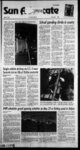
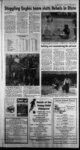
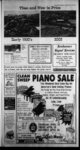
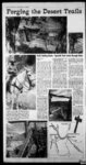
Show BB Sun Advocate Price, Utah Thursday April 18, 2002 Early Trading Route - Spanish Trail winds through Utah ery County headingtowards the north end of the San Rafael SwelL Green River has been a crossroad of several historical pioneers whose helped preserve the history the region. These include the famous documented their efforts as they Gunnison survey the. Mormon party the country we know today as headed by Oliver Huntington and John and Carbon counties. They lit-- Wesley RowelL The local museum In Emery out trails, homesteads Great River, named after the famous carved cralty and mines from the clifTa of one of the Powell, has an incredible .amount of most beautiful parts of America I had history of the area indudingthe Span- the opportunity last week to visit a ishTrafl and its significance to South- small portion of this area in Southern ern Emery County Hie horseback traders hauled al-Emery County with Jeff Newland, who manages a pack company out of Green most directly northwest into the Swell River. On horses we spent the day and although documents differ on the along the Eastern edge of the San exact route, it weaved its way north- Rafael Swell and got only a glimpse of west between what is now Highway 6 the vast country and the San Rafael Swell, following the Historically one small piece of the washes. Regardless of the exact route development happens in the earty it seems to have followed the watering 1800's as traders from Santa Fb, New holes, which were few andfar between Mexico developed a commercial route in this vast desert country Depending through Western Colorado and up into onhowdosetotheReefthetrailwent Eastern and Southern Utah on their it must have been quite a site to see the way to California. According to histo-- hnttea, pinnarip anH mflwaa hi thn although many of the docu- - so-f- west as the horsemen made their By KEN LARSON Publisher nnt-rian- ar mented articles differ slightly, the trail was known as the Spanish Trafl. Think of the Trail as an early day trucking route before the times of freeways and train tracks. This 1,120 mile route en- tered Utah somewhere Jeff Newiand, owner and manager of JNC Trailrides and Outfitters of Green River is pictured on top of Molly, one of his pack mules. Newfand not only knows the country like the back of his hand, but is full of stories about the history of the area. The other pictures on tin page portray the Smith Ranch homestead, nestled on the Eastern edge of the San Rafael Swell. This homestead lies just west of the Spanish Trail that was used as a trading route from New Mexico to California between the 1820's and the late 1840's. r, northeast of Monticrilo and headed northwest into the Moab area crossing the Colorado River. It made its way towards Green River in what is now Grand County Just northeast of the town-rit- e of Green River is a sign indicating the location of the crossingof the Spanish Trail through a shallow part of the (keen Riven According to locals the crossing tied in with a large island in the Green River. This location lies in the Bhadows of the picturesque Book Cliffs. FYom this print the traders trudged hortb-weinto what is now Em-- IJ P,"l WIWWMIWMUBW.fk s, way through the washes and rocks, Stories have it that the trail took the northern route into Utah because of the difficulty in crossing the Grand yon and hostile Indian tribes in Ari-zona, From all accounts the two cant springs or watering holes along the eastern edge of the Reef include Trail Spring and Big Holes. From Green River SpringB, the trail emerges from the sands ri the Lost Spring Wish at Cement Crossing; on an unused grade of the Denver and Rio Grande railroad bed that was built across the northern part of the Swell in the early 80s a direct route from Green River to Price. Just east of this section of the Trail is the Smith Ranch homestead, still part of the ranching family today though weathered in time, portions of the building still stand, indudingthe ranch house, corrals, root cellars, and outbuHdingB.'niehomesteadwasbuilt along the ride of a wash and is located in a beautiful setting looking out towards the Book Clifts on the East, nestled and protected from the reef on the Mtest The Trail continues its way toward BigHbles in Pack Saddle Gulch. Beyond this area the trail emerges into an open area passing between the broken rim of the San Rafael River and of the thousand-fbot-difCedar Mountain on the right This couroe angles its way through the northern Reef until it drops into Huntington Creek and Castle Vdley Its a small bit ri history preserved inavast wilderness in remote Emery County Used between 1829 and 1848 the Spanish Trail was really the beginning of interstate commerce as hone traders brought their wares west to tee CaliforCan-docume-nts of Bignifi-mold- ed Al-ear- ty l8 nia coast st 'Ami i. . 'jPO -- |