| OCR Text |
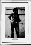
Show THE ZEPHYROCTOBER 1991 PAGE 20 dead water what might have happened to the Colorado River by Jim Stiles at a redwood and don't see hoard feet. I look at a river and don't see kilowatt hours. I look at a lake and don't see an aqueduct. I look at a gorge end don't see a demsite. 1 look leery Russell -- On the loose Last moo fl, the Secretary of the Interior Manuel Lujan, speaking for the Bureau of Reclamation, did something unusual. Lujan took measures to reduce the destruction of the Grand Canyon's ecosystem. For more than 25 years, Burec has released water from Glen Canyon Dam based on the demands of the electricity consumers. The lake's waters fall through the giant penstock tubes within the massive concrete plug which spin the turbines which generate electricity that powers microwaves and air conditioners and VCRs in Phoenix and LA. When the demand is great; the Bureau releases more water. Sometimes, as a result fee lake rises and falls as much as 13 feet in a single day. An eight year, $15 million study has clearly shown that fragile beaches are being washed away, plant life has been disrupted, same endangered fish are declining rapidly. But on August 1, Lujan decreed that Colorado River fluctuations would be reduced by Ihre&quarters and by onethird the river's high water line. It is the first time that anyone can remember the Bureau of Reclamation assuming die role of protector instead of destructor of the environment Its solid reputation for following the course that generates the most revenue has not fluctuated at all in 30 years; a far cry from die ups and downs of the river it has manipulated for so long. Glen Canyon Dam itself, more than any other project, symbolizes the short sightedness, the greed, and the stupidity of the Bureau of Reclamation. The dam destroyed the most intimate and intricate canyon of the Colorado River, it buried thousands of priceless archaeological sites, displaced hundreds of species of wildlife and left in its place a 190 Foul mile long reservoir that is fast living up to its nkkname-Lak- e But believe it or not; it could have been wane. Recently, I obtained a copy of a remarkable document It's called "A Survey of the Recreational Resources of the Colorado River Basin, produced by the National Park Service in 1950. The Colorado River and report describes the Bureau of Reclamation's plans to dam practically every mile of the In River Basin where Colorado the those Service endorses the Piuk its tributaries. And with few exceptions, plans, saying: few lakes occur naturally, the creation of large bodies of water is of great recreational importance." What follows are passages from die report They describe what might have been the bite of the Colorado River Basin, had the Bureau of Reclamation (with the NPS cheering from the sidelines) been able to achieve its goals. free-flowi- ng Potential Reservoirs vately owned lands, and public domain. The grazing land greater part of the area is having little scenic or recreational value. However, in the vicinity of the Dewey Bridge there are distinctive sandstone cliffs and box canyons, and the canyon of the Dolores River which enters the Colorado River about a mile and half above the dam site is colorful and interesting. The Westwater Canyon of the Colorado River, the principal scenic feature of the reservoir area, is about 12 miles long and several hundred feet deep. Deep tributary canyons enter on its easterly side, and both the main and tributary canyons are characterized by sandstones that have a pleasant reddish hue. Views from the west rim are good, particularly in the Big Hole section, and from the air the Westwater Canyon and the numerous and intricate side canyons on the east form a notable scene. When compared, however, with some other areas on or near the Colorado River in the same general region of eastern Utah and western Colorado, such as the Colorado and Arches National Monuments, the canyon of the Colorado River between Dewey Bridge and Moab, and the amazing landscapes near the junction of the Green and Colorado Rivers, the West-wate- r Canyon is clearly of secondary scenic importance. The proposed reservoir would be a large lake of very irregular shoreline, and because most of the area it would cover slopes somewhat gently toward the Colorado River, drawdowns would expose considerable amounts of unsightly bottom. In the locality of the Dewey Bridge, where at full reservoir the water would be approximately 290 feet deep, a good deal of the colorful sandstone would be submerged. In the vicinity of the Big Hole portion of Westwater Canyon, the reservoir at high-watlevel would be about 200 feet deep, materially altering the appearance of the canyon by reducing its apparent depth and substituting a still body of water for the rapidly flowing river. Nevertheless, the canyon would retain some.ofits scenic value, and recreational resources would be added, because the lake would offer opportunities for boat trips, fishing, swimming, and camping. semi-dese- The survey of the recreational resources of the Colorado River Basin involved the consideration and investigation of about 135 potential reservoir sites. (Plate 15 in pocket.) The object of the investigation was to ascertain, at least in a preliminary way, the character of the area which would be flooded or affected by the reservoir; the recreational and scientific importance of the scenic, historic, geologic, archeologic, or biologic features of the reservoir area; the effect the potential project would have on important existing features; and the potential recreational values of the reservoir area. In most instances, project plans had not been completed for the dams and reservoirs, and in many cases the only information available at the time was the approximate location and purpose of the dam and the size of the reservoir. Hence, it was not possible to make a final appraisal of the potential recreational values of the reservoir. Generally, however, it was possible to determine whether important recreational features existed in the reservoir area and whether the potential reservoir would or could have recreational values. The Dewey Reservoir site is on the Colorado River, in eastern Utah and western Colorado and about midway between the north and south boundaries of the two States. By far the greater part of the reservoir site, which is more than 40 miles in length, lies in Utah. Only a small portion of it extends into Colorado. The tentative dam site is about 30 miles upstream from Moab, Utah, at the of the upstream end of the spectacular Red Canyon Colorado River that lies between the dam site and United States Highway 160 near Moab. The purpose of the proposed project is the development of hydroelectric power. Preliminary studies by the Bureau of Reclamation indicate a water surface of about 66,000 acres at full reservoir and about 21,000 acres at dead storage. Maximum drawdown, which normally would occur during the winter months, would be about 1 06 feet. Lands involved include State school lands, pri rt er It has been indicated by the Bureau of Reclamation that a road for construction purposes would have to be built from United Stales Highway 50 and the Denver and Rio Grande Western Railroad to the dam site. It is recommended that this be built as a permanent road, to connect with the unsubmerged portion of Utah State Highway 128 between the dam site and United States Highway 160 near Moab. This would, in effect, retain the present route from Moab through the spectacular Red Canyon of the Colorado River to United States Highway 50, which not only is used as a short cut from Moab to Grand Junction, but affords access to the remarkable spires and buttes of this part of the Colorado River Canyon. SAN JUAN DIVISION This division includes the San Juan River drainage and the western tributaries of the Colorado River between the junction of the Green and Colorado Riven and Lees Ferry. The major dam and reservoir proposals in this division, Glen Canyon and Dark Canyon Dams in the Colorado River and the Goosenecks, Slickhorn, and Great Bend on the San Juan, are discussed in Chapter VIII. The Bluff Dam in the San Juan River, 12 miles below Bluff, Utah, would create a reservoir with a maximum surface area of 28,500 acres and a minimum area of 7,800 acres. Since the reservoir would be located in a region of very sparse population and is to serve primarily for silt retention and flood control, it is not likely to have much value for recreation. The natural scenic attractions in southeastern Utah and northeastern Arizona will, no doubt, appeal more to the tourists than will this reservoir. The potential dams and reservoirs would eliminate the thrills of boating down the untamed rivers. The depths of the river canyons would be reduced. The deadly rapids of Cataract Canyon, responsible for the tragic ending of several canyon voyages, and the sand bars and the often shallow waters of Glen Canyon, would be gone. But the Glen Canyon Reservoir would provide access to the wonders of the canyons. The Grand Canyon Bridge Canyon Dam and Reservoir. Nineteen miles northwest of Peach Springs, Ariz., in the m-visited western half of the Grand Canyon, the Bridge Canyon Dam may some day rise to the towering height of 740 feet above bedrock if the present plans of the Bureau of Reclamation are carried through. Exceeding Hoover Dam in height, this dam would in turn be dwarfed by the canyon. Though the dam would raise the water 672 feet to a maximum elevation of 1,876 feet above sea level, the multicolored canyon walls would tower more lake. The quiet than 4,000 feet above the fiord-lik- e water of the lake thus created would extend upstream 93 miles to within a tenth of a mile of the mouth of Kanab Creek. At normal water surface elevation 1,866 feet, it would extend to within s of a mile of Kanab Creek. The minimum surface elevation of the reservoir would be seldo- four-tenth- 1,645 feet. Bridge Canyon Dam primarily for the generation of power. Coincidental with the construction of the BridgelCanyon Dam would be the construction of the Coconino Dam on the Little Colorado River 49 miles upstream from the Colorado River and the Bluff Dam on the San Juan |