| OCR Text |
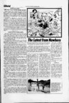
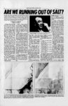
Show 8 SALT FLAT NEWS, MARCH, 1975 change when there is water once again on the flats. In conclusion, it appears The Salt Flat News is publishing a three part story on the of the salt flats. The first part, ecology and geo-mechani- cs outlines the current dilemma of thirteen million tons of missing salt. Part two of this series will be published in April and will discuss the request by Kaiser Industries to relocate their evaporating ponds on the salt flats. by Richard N. Goklberger Reporter-At-Larg-e Thirteen million tons of salt, eleven million cubic yards, has disappeared from the salt flats. That is enough salt to fill thir- Harold J. Tippetts, director of The Division of State Parks and Recreation, originally' requested this study be prepared teen thousand ton because of the concern of many hopper cars of salt. This is one, parties that the salt flats ap. of the more striking conclusions peared to be receding Until ree redrawn from a report cently, Mr. Tippetts office had leased in December of 1974 by recreational jurisdiction of the ; the Utah Geological Society. salt fiats. " The name of this report is: ReThis situation is not our port of Investigation 91,' problem anymore, Mr. Tippetts Bonneville Salt Flats: A Compartold us. Mr. Tippetts is quite corison of Salt Thickness in July, rect, as Utahs lease on the salt 1960 and October, 1974. flats has expired and reverted ' The thirteen million of to the federal government. back figure tons is based upon the net reducis It now under the jurisdiction of tion of the salt crust in one the Bureau bf Land Management. hundred and five test holes that The BLM director for the were originally drilled' in July of state of Utah is Paul Howard. holes were Mr. Howard wrote usthat his 1960. Ninety-seve- n redrilled in October of 1974. All bureau now has complete manof the one hundred and five agement and administration reholes were drilled on the north sponsibility for the national reside of Interstate highway 80. source lands in the Bonneville Salt Flats speedway. This in. According to Mr. McCleary of the Utah State Highway Departdudes lands previously induded ment, the holes were four inches under a special land use permit in diameter and two feet deep. to the State of Utah, Division of Parks and Recreation. Their perRoy D. Tea, chief of ti e materials engineering section, carried mit expired bn May 31, 1974; to out the actual testing of the hundate, the state has not made apdred and five holes. Mr. Tea also plication to renew their expired m did the original drilling and testpermit. In ing in July of 1960. July of 1974, Roy D. Tea The report was prepared by of the highway department conthe Utah Geological Society, a ducted the survey to determine state organization headquartered the- - thickness of the Bonneville on the campus of the University salt crust. In a written summary State of his report, dated October 29, r of Utah, and the Utahmaterial highway Department, 1974, he defined three types of division. .salt: engineering one-hundr- ed - five-pag- - . -- - r that the hard crystalline salt crust has decreased in thickness. Another conclusion derived from Report 91 is that the salt flats tend to mlbve up and down. Bruce N. Kaliser, who in 1967 prepared a report on the hydrology of the salt flats, noted that it was quite unusual that the salt tended to migrate away from the eastern extremity but built up near the northwestern portion of the flats; Mr. Kaliser could not offer any explanation as to what caused the phenomenon. Another finding was that the brine content in the test holes showed a Governor Rampton: J will continue to keep an eye on it- change as much as one half foot : and more Hard Salt during the morning and afterapparently is white, hard, salt dense crust of fairly pure, subject to depletion where not noon of a single day. . The final conclusion this recoarse crystalline sodium covered with hard salt. Th? difference of the hard port offered was that additional chloride, approximately 95 research to determine the direcfrom 1960 to 1974 is as folsalt soluble. ' tion and rate of brine movement lows: Soft Salt greenish, sandy by the injection of fluorescent textured, soft mixture of clay - 20 holes havea gain of from tracer and soluble salts induding dyes was needed. This in' 0 to 0.35 feet ' formation would bear most disodium chloride 33 holes have a loss of from ' crystalline to preserve and coarse crystalline gyprectly upon attempts ' to 0.10 feet 0.01 the salt flats. sum. Approximately 60 sol22 holes have a loss of from Donald T. McMillan, director uble. V 0.11 to -- 0.20 feet of the Utah Geological Society, Clay light green, brown, or 7 holes have a loss of from whose auspices the report under gray saturated, soft clay, 0.21 to 0.30 feet feels that the key was AASHTO Classification A 6 4 holes have a loss of from to prepared, or A-- 7 lies under the soft salt. --0.31 to understanding the problem 0.40 feet : lies in more studies. .More reIn the 1960 survey, : 9 holes have a loss of from search in this matter is deemed 19,800,000 square yards of the 0.41 to 0.50 feet before a conclusion salt were found to be four feet 10 holes have a loss of from necessary can he told us. be thick. Mr. Tea's survey in 1974 extracted, 051 to -- 1.05 feet Governor Calvin L. Rampton, disclosed that no portion of the Mr. Tea also noted that the in a statement to the NEWS said, salt flats were four feet thick. I am watching it very closely; I The survey also noted that: outer periphery of the salt crust has less hard crystalline salt than am concemed the salt is missing. The 1960 hard salt measurements compared with the 1974 during the previous 1960 and Since water is high on the salt measurements show an average 1965 investigations. Part of this flats, I feel the salt is in solution. loss (for the 105 holes) of 0.194 we feel is due to lack of rain and I will continue to keep an eye on per hole. precipitation of salt. These areas it. The soft salt underlies and exGovernor Rampton added previously had' a thin layer of tends past the edges of the hard hard salt. This condition could that he does not propose closing - -- , . ; .Two views of the Bonneville Salt Flats from the air. On the left, an aerial composite On the right is an aerial composite of the same area taken July, 1970 by the UJS. 'taken in July, 1953 by the Army Maps Servide shows highway 40 running left to . Geological Survey. Interstate 80 and roadside rest stops are visible, also brine collec-rig(west to east) on the bottom of the picture. Geometric patterns on the south tion ditch north of the highway', side of the road are the evaporating ponds and canals of Kaiser Industries potash plant. ht . |