| OCR Text |
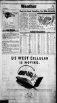
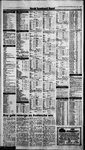
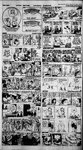
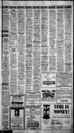
Show 7. ’ + mao SES 7 7 4 5 Monday, May 20, 1996 ~ Record heat heading for Mid-Atlantic By The Associated Press It was warm before daybreak in Cleveland, Chicago and St. Louis with temperatures ranging into the upper 70s. The Pacific Northwest was cool and cloudy. Record-setting heat was forecast ‘for the East and Middle Atlantic states, Readings could reach into the 90s, and even top 100 degrees in some areas as powerful winds from the West bring hot, humid air from the Plains and Ohio Valley. A band of thunderstorms was expected to move over northern Illinois and southern Michigan. Some of the storms could be severe, with wind gusts of up to 55 taph, one-inch hail and heavyrains. Another group of heavy showers and thunderstormsthat stretches northern New York to Maine could move north. The front should be followed by much warmer ' Rain and thunderstorms over the Pacific Northwest could continue, while some areas see some patchy sun. Already the for the mountains and deserts of southern California and along the Northwestandinto the 80s and 90s in the Northeast, mid-Adantic and South. The West Coast, Plains and upper Great Lakes regions may reach highs of 60s and 70s. Parts of the desert Southwest could top SALT LAKE, OGDEN AND PROVO: Tonightfair. Lows mid- By The Associated Press Cincinnati 8 70 cr 8 71 cdy 86-67 addy 8% 68 03 87 64 cir 88 68 cir Portland.Ore 61 8% «869 oot Corpus Christi 8875 cdy 0 peas Worth 92 73 a Des Moines 85 58 16 rd S NORTHERNIDAHO:Tonightslight chance of evening showers otherwise partly cloudy. Patchy early morning fog. Lows 35 to 45. Tues- day mostly cloudy with a chance of afternoon re y y . storms. Highs 60 to 65. 5; showers and thunder- afernone } abe wei ©CENTRALIDAHO:Tonightisolated evening showers otherwise ies Atiantic City Austin Balt Itimore Baton Rouge Billings 2 > 93 68 933 633 S3 0 4 89 showers in the afternoon. Highs mid-60s to mid-70s. ctr Eugene 61 40 oy 2 @ ae & ~* Fort Smith m™ m 2 65 Junction rand Grand Rapids Great Falls Green Bay Greensbo.NC. Harrisburg m Hartford Spefld m Helena 1 10°) 68 cd a ey a5 Gk G37) > ody 3 92 % 6 64 63 87 64 6i ms ee clr oe ety Lubbock ubboc 105s Madison 93 7 & 6S aejis MiamiBeach o 85 “4? oy clr 77) om Midland-Odessa 10370 Macon Milwaukee 39 73 599 68 oor ne Roanoke or Rochester clr Rockf ‘ockford dy Sacramento om clr om ody coee or clr ¢ ST oly 64S] B 8 94 .1S. 49° c& lr cir 41 ody . = = 93 66) clr ‘ 8 Of 5 69 on 7B oe 4 me 50 ctr St Louis 4 awe a 2 2 6541 oor San Angelo % = es «83 clr = 2B a 16. 68$6 olyel catep San Franeisco ewe er Na Glee New York City 89 % Su ee tice San Juan. ED =Ly 9S s* ody Savannah Seattle Shreveport 97 59 8 2 ody Sioux Falls Oklahoma City Omaha 8 3 478 88 89 6 68 #73) clr ody cir 72 ete 750 cr 07 72 62 ady Sante Fe St Ste’ Marie Sioux City m or 6 #72) 89 ashville ™ 68 -alem. bay Salt Lake City ntonio edly? 07s 6 32 65 Mobile om Newark clr Norfvk.Va. cr North Platte 42 dy Rapid City 61) MdeSiPal ody =ie ® Portland. Maine Providence m Pueblo Raleigh-Durham 7 Louisville 03m 9077 0.53 dy 0 y Evansville FatWayes, Fresno o Chicago li Ir -O72 #216 4 edy Charleston.W.Va. 91 63 CharloteNC, 467 Chattanooga 9 6 Cheyenne 74 69 ‘aribou, Maine Casper Charleston.$.C. ae ” 89 aoe See, : Es ne Flint ‘ cha i ing, cloudiness with aa chance offyafternoon showers ana thunderstorms mainly western areas. Highsin the 60s. NEVADA Los Angeles 6753 Wise partly cloudy and continued cool. Lows 35 to 45 Tuesday inereas- NORTHERN AND CENTRAL NEVADA: Tonight partly cloudy Lows mid-30s to the mid-40s. Tuesday mostly cloudy. A chance of ae ik ok . © ey 43 clr Boston 4 a 677) 69) chance of afternoon showers and thunderstorms especially western Brid 68 Lexington 53 97 ay 1% a 0 sm 9 E} Paso Elkins 87 oe asc Boise : rcs 8869 lr ¥9 69 cidy 9 44 dy — zl Flagstaff partly cloudy. west andRe mostlyclear east.ear Patchy moming fog. Lows 30 : TOO GE to 40 coolerin some high valleys. Tuesday increasing.cloudiness with a azeas. Highs 55 to 65 Rewemie ®SOUTHERN IDAHO:Tonight isolated evening showers other- Buffalo ayton Daytona Beach Denver 73 73 Knovvill cir g S848 mss 4 Kansas City 68 Anchorage Orlando Lake Charles Lansing Las Vegas 86 - IDAHO z dy SSD ee 9 60 100 76 Dm 3 Anan DIXIE: Tonight clear. Tuesday sunny. 76 = coma Philadelphia Prioenit : eee Akron,Ohio 2 cr 8962s 8 6 89 ame oe sville 2 clr Indianapolis 8771 Jackson Miss, «896 clr Jack B 7 © on ot OR Tm 2 SOUTHERN UTAH:Tonightfair. Lows upper 30s to mid-S0s. werque AllentownPa. Amarillo Honotulu eiesael 3 oe 73 eae ColumbiaSC. 98 -—«68—lr ColumbusGa 9268 edly Columbus.Ohio 89 70 ci Coon 8) 33. aly Tuesday mostly sunny. Warmer. Highs 80s to lower 90s. ae 2: ee National Temperatures znd 40s. : Tuesday mostly suniny inr the morning. Ain Becomingpartly cloudy duriMonday ing the afternoon. Much waimer. Highs mid- and upper 70s. Temperatures indicate previous day's high ©NORTHERN UTAH: Tonight fair. Lows 40s to near 50. Tuesday and ovemight low to 8:31 am. EDT. 5 Hi Lo Pre Otk partly cloudy. Much warmer. Highs 70s. : Abilene.Tex 2 Gt y © 1996 AccuWeather, Inc. Geax 100. ars - Gants separate high temperature zones for the day eastern slopes of the Rockies. It should be hot and sunny over most of the Southwest. Showers and thunderstorms in southern Florida should give way to mostly cloudy conditions Heavy storms, however, could remain over the Gulf of Mexico Today's temperatures could range into the 60s across the OyThewotPret UTAH cede The AccuWWeather® forecast for noon, Tuesday, May 21. combination of rainfall withsnow melt in the region has caused some rivers to run high and fast. Windy conditions were forecast 6 O0:< *% 8i 78 eel 3 see 13 59 edly 7 dy 45 ody 72 dy ce 56.08 dys } = 3 } (3 ' : . .:: & ' 7s ' : 3 ra 7 8 2 & : <“: ~= :' _ < = = = = = :: = -= ; still get the same great service from the same people cm you've always known.Just with a new name.Putusin the front of your Rolodex: {unless you know an Aardvark) along with our new number: 1-800-AIRTOUCH. —_ US WEST Celivlar is jumping ahead in the alphabet by changingits name to AirTouch Cellular. 4 " . Sandel 8 i\ ' $ tae AlRToucH Cellular “ “te ists ‘The new naihe for 1RMARSReuLAk Communications, Inc. All rights reserved, oe Le iw |