| OCR Text |
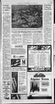
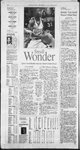
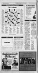
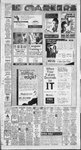
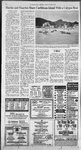
Show B10 TheS. alt Lake Tribune WEATHER Sunday The SaltLakeTribune WEATHER REPO Temperatures today’s highs / tonight's lows, C ag Wo Precip. Snow =] Rain A potentstorm moving acrosstheregio will produce snow, Flurries some heavy, with accu: 1 £9 f Storms ‘sn’ ePariecity wor3°) ~—smulationsof 2-4 inches around Salt LakeCity and higher amountsin the mountains. 36/2t/en showers will occur in the lower elevations of the south. A few snow hag City ayislc ® X “o ivan) Sn : Brian Head [St George 48/3210 Zion NP ° 46/29/C BrighamGi tty 3 006 Bryce NLP. Capitol Reet Cedar City SALT LAKE/BAVIS GO. NT am, = * a : Duchesne 0.05 Escalante ioe 34/20 40/26 Heber City odae aod| Provo” \ vernal 33/20/c Peti, Biche mea Gedioc| CagarCy A2i20/6 36/iB/c Laks Powell| as eae doretic “Og Wed before. bFarkely i Provo 33/22/pc are Price THC B4/18/C \ ¥] er ®] Provo 33/20/e feral) \8O/13/c | Richfleld (=e. °°0@sen" ge Aoba/sn, Price} Cedar city! 44l24/pc ae Lake,Powell Cedar city 46/26/c opeot vbyosen #'56/3; Gi eed 0.02 : 0.01 ie0! ae » 30/25/80 HOURLY UPDATES ON eanaie CONE Yesterday's NationalExtremes(in the 48 contiquousstates) Low: -2 in Alamosa, Colorado High: 85 in Fort Myers, Florida ome Stockholm 0 1 Tokyo Vienna Warsaw 31/26 Today Tonight A Last New Sunrise Sunset 7:26 am 5:03 pm Nov30 Dec? Moonrise 2:46 pm Rain T-Storms Snow Flurries CL peeten Hilo Prep He, WOH 48/28 5227 po 43/24 8 2817 Tr 2414s -25N7 s_ Birmingham. 72/63 1.22 68/57 s 71/61 sh Atlanta Billing 72160 0.02 39/30 0.01 Bismarck 3786 Tr Boston Butfalo 5040 Tr 65/44 Charleston, SC Chicago Cincinnati Cleveland Columbus, 0H Concord, NH Dallas Des Moines Detroit Evanston Fairbanks 02 79/63 0.05 40728 0.01 6449. 0.19 028 6049 Tr 67/55 0.08 49/80 0.01 7153 Tr 45729 56/50 0.17 62/49 Tr 262 0.09 19/1 72/54 pc 29/18 sn 2648 c 38/728 sn 60/48 sh 63/42 sh 75/89 sh 35/23 505 59/38 6040 6089 59/41 ©7551 46724 48/35 55/88 3123 B19 sn po pe c pc sh s st pe c sn s 70/56 sh 24/13 sf 19/10 sf 38/24 ¢ 56/43 pe 52/88 pc 75/57 c 29/3 52/40 60/51 54/46 57/49 55/33 66/39 386 49/29 50/42 299 G15 Ice Regionalcities in bold face 22/4 st 71/42 po 62/88 s_|_ cowarecane None NS AROUND THE NATION 34/14 sn 7352 s 63/46 5 ighway Conditions Shown are the noon positions of expected precipitation Oo SS aa a Dec14 Dec22 Moonset 1:58 am 32N7 0.03 7348 6242 0.06 Air Quality 975-4009 First GoS 0 O® en Austin Baltimore UTAH Weather 524-5133 batapelaat ui n 53 Avalanche264-1581 pe SON AND MOON ‘ i ‘West Valley Zion NP. TOMORROW'S PRECIPITI Tehran city Albuquerque Anchorage i TOBAY’S PRECIPITATION Sydney wr ‘ oor Park. City a V25/i )'° prova’® ‘Vernal Nordic Valley Park City Powder Min. Snow Basin 0 oot Thua 38/25/sn 82/21/st Deer Valley tr tr ‘Logan. Beaver Mtn. Brian Head Brighton The Canyons re tr park city Pan Price Soran Moab Sa/20/st*%| George Nephi ogden orn See Seiteie, Pre Randopn |Cedar city! ‘azypajé™| 98/14/¢ Lake Powell HiGeore B8/21/c i Saupe 34/1 6/po PF Woab * #52/30/pe ® dao | tones London Madrid M Sundance : G ir es UTLOOK Salt Lake/Davis coountties UtahCounty Good Weber County Good Saowird_—0 Solitude 0 FamGe Green River Hanksv Snow Clouds and Clouds, showers sunshine; _imited possible chilly "Sunshine showers ae Dea ag Kong Istanbul Hirtit ga/2aisn 6 hike showers will linger © Ephraim 34/20/sq tonight 35/2118 ‘* Richfield aides S7/e2he aarpan® . Cupitol Reet Ne” Monticello| UTAH YESTERBAY 38/23/i SNGEOS| city Hi/Lo Prep Bryce ; Ata 2015043 ) NP Blanding \ Fronts at their noonposition. Temperature bands are highsfor the day. showersduring the afternoonhours. Rain Floosevelt Ron @ Nephi @Delia ye: Utahhigh 57 até Saint George Utahiow Head Utah haghest precy 43" at Ata SALT LAKE ALMAMAE snow will taper to snow * saeuen Heber Cityoe 36/2dsn* Statistics through 6 p.m st r pc s pc pc pc pe sh pe sf s_ | Flagstaff Gallup Grandse Hartford Honolulu Houston Waho Falls Indianapolis Jackson, MS Jackson Hole Kansas City Las Vegas Little Rock Los Angeles Louisville Memphis Mesquite Miami Milwaukee Minneapolis Missoula Nashville Now Orleans New York Oklahoma Cty Orlando Palm Springs a5 473 46 46/40 0.11 83/70 7557 Tt 34720 0.01 64/55 053 7a64 113 278 59/43.0.38 65/41 0.09 6654 042 59/47 0.72 68/57 0.56 67/56 1.06 59/40 81/73 S2N6 sf 425 sn 38/21 i 57/47 ¢ 8671s 768s. 3421 sn 56/39 pc 7257 Ss 297 st 54/42 po 55/38 pe’ 6646 5 64/51 po 62/42 pc 66/49 s 53/5 ¢ 82/68 s 36/14 pe 375 pe 378 st 586s 84/69 c 77/45 sh 30/16 st 61/48 po 7658 sh 288 st 56/27 c 5237 ¢ 65/42 c 66/54 sh 61/54 pc 66/49 “sh 49/82 ¢ 8268 s 58/49 0.20. 54/47 1.04. 41728 50/34 pc 38/27 c 35/28 sn 78/70 0.82 74/65 po 67/61 0.76 61/50 64/43 83/61 68/51 0.12 0.11 Tr Tr 67/43 s 6452 67/42 82/60 71/4B 6 po pc po Philadelphia Phoenix Pittsburgh Pocatello Portland, ME Portland,OR Raleigh Reno Rexburg Richmond Sacramento St Louis SanAntonio San Diego Sanfrancisco. e Seattle SiouxFalls 69/45 70/47 65/43 18 48/29 48/43. 6751 53/85 30/24 64/9 59/50 62/57 76/55 6453 62/51 4715 48/40 4189 45/40 F 3680 i 30/20 sf Sun Valley Tahoe 78/65 sh Trenton 6647 0.01 67/57 sh_| 62/48 62/33 81/60 67/42 s_ | pe s c | | | | | Tampa Tucson: Washington WindowRock Yellowstone Tr 261 GAD 65/44 pe” 62/40 sh 36722 sn 57/45 c 46/98 + 70/49 r 44/26 ¢ 33/20 sf 66/48 56/42 sh 50/43 s 7352 s 69/50 pe 56/48 c 4620 ¢ 46/38 sh 3626 c 6342 so GOAT pee 59/46 sm 3/6 st (S67 46/96. pon 65/46. po 41/24 sa” 30/13 sf G52 s 53/41 62/42 c 73189. pe 6953 po 59/49 Fr 3916 s 44/36. pe 318 sn 41729 3221 0.10 40729 0.74 36728 sn 36/22 sn 3/12 st M24 SANG © 347 sa 0.02 Tr 0.17 037 0.65 0.02 0.15 0.86 133 Tr 0.77 83/65 70139 64/44 0.12 45/7 38/22 0.09 83/63 pc 6146 5 6181s 6452 1 425 sn 26/12 sn 81/63 s STARR Ss 61/84 po G54 37NS pe 22/5 sf ‘All maps, forecasts and data provided by AccuWeather, Inc. © 2001 _nimbo,wrh.noaa.gov/saltlake rae Peers} OER RCC ET ORY Mem ena ora RUC oe the Officially ae PPR Tne EN aan EMU rere este) MOA COU rg ne Lh Dee mel ell TE Coa Mon elo EtCOLLECTIO Start your collection — get your FREE album inside your newspaper next Sunday. o—_—_—_-—6 © |