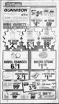
| OCR Text |
Show - rm J- ' t ' Salina SunGunnison Valiev News 'Pajie 6 Together with 783 shares of Water Stock in the Gunnison Irrigation Company. March 8. 1995 PobllcNofiices Published for yoar information and right to know Notice of Trustee Sale ! t Containing 20.31 acres. EXCEPTING THEREFROM that part in the Railroad right of way. , The following described property will be sold at public auction to the highest bidder, payable in lawful cash money of the United States at the time of sale, at the front door of the Sanpete County Courthouse in Manti, Sanpete County, Utah, on April 5; 1995, at 10:00 a.m. of said day for the purpose of foreclosing a trust deed executed by AS IN- -, DIVIDUALS Vaf Jean Hansen & Miriam D. Hansen (aka Meriarrv Hansen), hid wife, Mariel 0. Hansen & Etta Mae Hansen, 'his wife, Stephen L Hansen & Janet Li Hansen, his wife, and LaRell C. Hansen & Debra Lee, P. Hansen, his wife, and Hansen Dairy, Inc.,, a Utah corporation, as TpySTORS, in fa-- , vor of the United States of America formerly ; acting through the Farmers Home Administration, United States Department erf Agriculture, as TRUSTEE, for the benefit and Security of the United States of America, as BENEFICIARY, dated June 26, 1986' and recorded June 27, 1 986, in Book 271 , Pages 1 Official Records of 606-6, Sanpete County, covering real property located Jn (Sanpete County, Utah and more particularly described as: Vf ? Parcel 6: Northeast Quarter of Southeast Quarter, Section 27, Township 19 South, Range 1 East, Salt Lake Meridian; Also beginning 5 chains West and 989 feet South from the Northeast Comer of the Northeast Quarter, Section 27, Township 19 South, Range 1 East, Salt Lake Meridian; thence 331 feet South, East 5.00 chains. South 20.00 chains. West 20.00 chains, North 659.40 feet to the North side of Railroad, Northeasterly along North line of Railroad 1392.50 feet to beginning. Less 3.14 acres to Railway. Containing 73.37 acres, more or less. Parcel 7: Southwest Quarter, Section 26, Township 1 9 South, Range 1 East, Salt Lake Meridian. Containing 160 acres. EXCEPTING THEREFROM that part in the Highland of all minerals in or unCanal, and one-ha- lf der said land including, but not limited to 1 f EXHIBIT A" - metals, oil, gas, coal, stone and mineral rights, mining rights, and easements, rights PC other matters relating thereto, whether expressed or implied. ' Parcel 1 : Beginning 18.65 chains South of the Northeast Corner of the Northwest Quarter of the Southeast Quarter of Section 27, Township 19 South, Range 1 East, Salt Lake, Meridian; thence West 12.38 chains, South) 15 deg. 30' East 320 feet, South 74 deg. 30' West 50 feet, North 15 deg. 30' West 150 feet, South 74 deg. 30' West 789 feet. South 14 deg. 30 West 4.65 chains, East 4.07 chains. South 5.5 chains, East 23 rods, North 24 feet, Northeast Direction 1200 feet to point 635 feet North of the Southeast Corner of the Southwest Quarter, Southeast Quarter,., Section 27, Township 19 South, Range 1 East, Salt Lake Meridian; thence North 11 .73 chains to beginning. Containing 29.08 acres. Parcel 8: Beginning 20.20 chains West, Northeast Comer, Section 33, Township 19 South, Range 1 East, Salt Lake Meridian; thence South 11.10 chains, North 89 deg. West 11.40 chains, North 1 deg. East 10.90 chains, East 1 1 .20 chains to point of beginning. Also beginning Northeast Corner, Northeast Quarter, Section 33, Township 19 South, range 1 East, Salt Lake Meridian; thence West 20 chains, South 1 0.75 chains, East 20 chains, North 10.75 chains to point of beginning. Containing 33.93 acres. EXCEPTING THEREFROM that part in the Railroad right of way. Parcel 2: Beginning Southeast Corner Sect19 South, Range 1 East, Salt Lake Meridian; thence North 10.90 chains, South 88 deg. 30' West 1 1 .20 chains, South 6.35 chains, North 89 deg. West 20.20 chains, South 4.85 chains. East 31 .20 chains to beginning. Containing 21 .30 acres. Parcel 9: Beginning Northwest Comer, Sec1 East, Salt Lake Meridian; thence South 10.45 chains, Northeast on a curve along D.R.G.W. Railroad 13.85 chains, West 9 chains to point of beginning. Containing 4.70 acres. ion 28, Township tion 34, Township 19 South, Range Parcel 10: Beginning 28.75 chains West, South 11 deg. West 1.50 chains Northeast Corner, Southeast Quarter, Section 27, Township 1 9 South, Range 1 East, Salt Lake Meridian; thence South 11 deg. West 18.30 chains, South 74 deg. 30 West 1 6.50 chains, North 14 deg. 30' East 10.53 chains, North ' I afcresV 46 deg. East along West side of D.R.G.W. - Railroad Right of Way to point North 88 deg. Parcel 4: Southeast. Quarter of Southeast .1 West 3.45 chains of beginning, South 88 deg. Quarter, Section 27, Township .19 South, East 3.45 chains to beginning. Less Railroad. Containing 19.59 acres. EXCEPTING Range 1 East, Salt take "Meridian, ContainTHEREFROM that part in the Railroad right ing 40 acres. Parcel 3: Beginning 11 .26 chains West, 4.30 chains North, from Southeast Comer, Southeast Quarter, Section 28, Township 1 9 South, Range 1 East, Salt Lake Meridian; thence North 89 deg. West 20.20 chains, North 5.45 chains, North 88 deg. 30' East 20.20 chains, South 6.35 chains to beginning. Containing thence North 10.90 chains, North 88 deg. 30' East 20.20 chains. South .43 chains too Railway, Southwest along Right of Way to Section Line, West to point of beginning.' , Containing 18.09 acres. Together with all the improvements and thereunto belonging or in anywise appertaining thereto, including, but not limited to, any and all irrigation and sprinkler irrigation equipment and lines; the water and water rights, ditch and ditch rights belonging to the above and foregoing described tracts of land, including but not limited to 783 shares of water in the Gunnison Irrigation Company; and any and all grazing privileges, permits, licenses, or leases. real estate will be The offered for sale under two methods. In the first method, Parcel Nos. 2, 3, 8, 9, and 11 will be offered for sale as a single tract (Tract 1) with 212 shares of Gunnison Irrigation Company Water Stock and appertaining sprinkler system; Parcel Nos. 1,4,5,6,7,10, and 12 will be offered for sale as a single tract (Tract 2) with 400 shares of Gunnison Irrigation Company Water Stock and appertaining sprinkler system; Parcel No. 13 will be offered for sale as a single tract (Tract 3). In the second method. Tract 1, Tract 2 and Tract 3 will be offered for sale as a single combined unit. The final sale will be closed using the method that yields the highest overall bid price for the offered property. d The minimum bid for the real property, water rights, and appertaining sprinkler system will be as follows: r Tract 1: $123,321.80 Tract 2: $180,996.06 Tract 3: $23,601 .55 t. Tract 1 , Tract 2 and Tract 3 combined: $327,919.41 1 71 shares of Gunnison Irrigation Company Water Stock will be sold separately, and the minimum bid thereof will be $450.00 per share. ' Parcel No. 13 will be sold subject to a Mortgage executed by Stephen L Hansen and Janet L. Hansen in favor of the United States of America, dated April 26, 1974 and recorded on the same date in Book 173, Official Records of Sanpete Pages as assigned. County, The sale will be made without covenant or warranty regarding title, possession, or encumbrance, to satisfy the obligations secured by, and pursuant to the power of sale d contained in the trust deed. In addition to, but not in limitation of the previous statement, it is specifically noted that no representation, covenant or warranty of any kind or nature is made with respect to the title to the following described real property: Beginning 11.5 chains North and East 1 2 chains from the Southwest Corner of the Southeast Quarter of the Southwest Quarter of Section 27, Township 1 9 South, Range 1 East, of the Salt Lake Base and Meridian; thence West 122.31 feet, thence North 14 deg. 30'00" East 306.90 feet, thence north 74 deg. 30'00 East 36.75 feet, thence South 14 deg. 3009" West 344.651 feet to the point of beginning. Containing .8856 acres. There may or may not be outstanding taxes or water assessments which would not be extinguished in the foreclosure sale. cial Records on August 9, 1 994, in Book 355, Pages 248-25Dated this 22 day of FEBRUARY, 1995. United States of America By: Glen F. Wood Title: Acting District Director Rural Economic and Community Development State of Utah United States Department of Agriculture Notice of Default and Election to Sell Published in the Gunnison Valley News and 1 said real property was recorded in said Offi- - Salina Sun on March 1,8, and 1 5, 995 above-identifie- d Parcel 12: Beginning Southeast Corner, Southwest Quarter of Northeast Quarter, Section 27, Township 19 South, Range 1 East, Salt Lake Meridian; thence West 7.81 chains, to R.G.W. Railway, North 45 deg. 33 East 10.90 chains, South 7.71 chains to point of beginning. Containing 3.01 acres. Parcel 13: Beginning 8.75 chains West, South 11 deg. West 19.80 chains Northeast Corner, Northwest Quarter, Southeast Quarter, Section 27, Township 19 South, Range 1 East, Salt Lake Meridian; thence South 74 J deg. 30' West 300 feet, South 15 deg. 30' East 150 feet, North 74 deg. 30' East 50 feet, South 15 deg. 30 East 170 feet, North 74 ( deg. 30' East 250 feet, North 15 deg. 30' West 320 feet to beginning. Containing 2 acres. above-describe- r. EXCEPTING THEREFROM THE FOLLOWING DESCRIBED PARCELS OF ; ; LAND Beginning at a point 250.00 feet West of the Southeast Comer of Section 27, Township 19 South, Range 1 East of the Salt Lake Base and Meridian; thence West 350.00 feet, thence North 250.00 feet, thence East 350.00 feet, thence South 250.00 feet to the point of beginning. Containing 2.01 acres, more or less. RIGHT OF WAY, as follows: Beginning at a point 600.00 feet West of the Southeast Comer of Section 27, Township 19 South, Range 1 East of the Salt Lake Base and Meridian; thence West 720.00 feet to Quarter Section line, thence North 620.00 feet more or less to a fence corner, thence South 71 deg. 35' West along said fence 1145.00 feet, thence North 72 deg. 30' West 70.00 feet, thence North 17 deg. 30' East 25.00 feet, thence South 72 deg. 30' East parallel to and 25.00 feet Northerly of the said fence line 60.00 feet, more or less, thence North 71 deg. 35' East 1175.00 feet, thence South 625.00 feet, thence East 695.00 feet, thence South 25.00 feet to the point of beginning. Containing 1.12acres, more or less. 379-38- i NOTICE OF TRUSTEE'S SALE The following described property will be sold at public auction to the highest bidder, front door of of payable in lawful cash money of the United States at the time sale, at the the Sanpete County Courthouse in Manti, Sanpete County, Utah, on April 5, 1995, at 10:00 a.m. of said day for the purpose of foreclosing a trust deed executed by AS INDIVIDUALS Val Jean Hansen & Miriam D. Hansen (aka Meriam Hansen), his wife, Mariel O. Hansen & Etta Mae Hansen, his wife, Stephen L. Hansen & Janet L. Hansen, his wife, and LaRell C. Hansen & Debra Lee P. Hansen, his wife, and Hansen Dairy, Inc., a Utah corporation, as TRUSTORS, in favor of the United States of America, formerly acting through the Farmers Home Administration, United States Department of Agriculture, as TRUSTEE, for the ben1 efit and security of the United States of America, as BENEFICIARY, dated June 22, 987 of 642-64Official Records Sanpete and recorded June 23, 1987, in Book 280, Pages decovering real property located in Sanpete County, Utah and more particularly ' scribed as: East half of the Quarter and the East three Quarters of the Northwest Quarter of the Northeast Quarter of Section 34, Township 1 9 South, Range 1 East of the Salt Lake Base j County, w Meridian. Beginning at the Northeast Comer of the Northwest Quarter of the Southeast Quarter of Section 34, Township 1 9 South, Range 1 East, of the Salt Lake Base and Meridian; thence South 20 chains, West 20 chains, North 45 degrees East 28.28 chains to the point of beginning. West half of the Northwest Quarter of Section 35, Township 1 9 South, Range 1 East, of the Salt Lake Base and Meridian. Together will all improvements and appurtenances thereunto belonging or in anywise appertaing thereto, including, but not limited to, any and all irrigation and sprinkler irrigation equipment and lines; any and all water and water rights, ditch and ditch rights; and any and all grazing privileges, permits, licenses, or leases. The sale will be made without covenant or warranty regarding title, possession, or encumbrance, to satisfy the obligations secured by, and pursuant to the power of the sale trust deed. There may or may not be outstanding taxes or water assessments which would not be extinguished in this foreclosure sale. real property with all appurtenances wi be: The minimum bid for the contained in the above-reference- d above-describe- d above-reference- $9,281.56. Notice of Default and Election to Sell said real property was recorded Records on August 9, 1 994, in Book 355, Paged Dated this 22 day of FEBRUARY, 1 995. in said Official 248-25- United States of America By: Glen F. Wood Title: Acting District Director Rural Economic and Community Development State of Utah United States Department of Agriculture Published in the Gunnison Valley News and the Salina Sun on March 1,8, and 15, 1995. . x of way. Parcel 5: Beginning Northeast Comer of the Northwest Quarter, Southeast Quarter.Bec- - Beqiijrfyij.(pythwest Corner, O n N , 4 'W . I Square TVfrgPrlreft .17 42 .19 17 47 32 42 1 45 17a .78 2 42 US 1 V .14 17a 49 v .15 17 42 1 .19 47 2 I't Vi ' Steel Pice Size I'i M IV i .39 IV .32 IV 43 IV 48 27 IV45! 17 27 Foot Price 3Vi 44 3 Vi 149 43 4V 41 49 .79., 4 Vi 149 & 27 '45 .79 37s 44 37 42 44 -- Ak About Othf SJ2BI PALMERS METALMART 4V2j29 .200 Wi Stack UMd M-- P1M19 20' 8. Uhl 1(800) 840 540, E. 100 F S.9-1- 2 947-024- 9 768-333- 2 on the VERY best Bale Wagon sold. Will send video to show performance. - 1- . V Brand New Kirchner Hay Fluffer fSx Save 100$',of dollars Also 13 yearling Black Angus Heifers and good selection yearling bulls. 1 -- 801 53-4408 Horrocks Angus Ranch -3- . SAVE' MONEY...' WE CAN DO We don't automatically turn you down because you have had credit problems in the past. IT HAVE YOU HAD:,. . " CPC MORTGAGE ir . ... DO YOU NEED: Late Slow Payment Bad Credit Foreclosure Bankruptcy Cash Out of Your Equity Debts Consolidation Home Improvements mmmiieimcFC mortgage can helpi j The word is getting out about our farm and ranch loans. NUMBEBFOBWFORMATION: How do you tell which bank really understands farmers and ranchers? Well, you can look in a Zions parking lot. loans for land purchases. Credit lines for next And then you can look at what we re offering Inside. Like long-terseason's crops and loans secured by water stock. The fact is, no matter what your needs, we can tailor a loan program thats right for you. For complete Information, call your local Zions branch. Or stop in. (Were saving a spot for you.) m This GMX system mak$s your water the best it can be. Uses no salt, requires no maintenance, lasts a lifetime. hot, water heaters and piping Loosens hard water deposits on Chrome,. Tile & Porcelain. De-scal- es mm? ZIONS BANK M b r( f D I C' & HottMftf Lvndar |