| OCR Text |
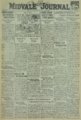
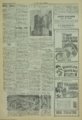
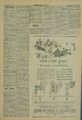
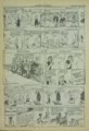
Show Thursday, August 20,1931 THE MIDVALE JOURNAL Sally Sez N]TJED ACQUISITIONS SINCE 1853 ALASKA, from Russia in 1867 HAWAII and PALMYRA, annexed ID 1894 PHIUPPINES,from Spain in 1898 GUAM, from Spain In 1898 PORTO RICO from Spain In 1898 TUTU! LA (Samoan~up), acquired 'h)' lfto ternational treaty 1n 1899 CANAL ZONE,Ieased from Panama In 1904 VIRGIN ISLANDS. from Dell mark in 1911 WAKE'ISLAND, MIDWAY, NAVASSA, and other emall islands, acquired since 1853 Fortunes are often Hdisinherite d"-sent away never to Teturn. Keep your money at home by patronizing home industry. These Brands Are Intermoun tain Made And Deserve Your Support - I • ,I HEWLE TT~S . . ~~J~#,. . S . ·J ·' -..' ,,··,.. "' ...... -·.r.·r..:;. upreme . .,. am· . •·/!.:? . . .'"" .. ~ /" ' UTAH HIGH SCHOOL OF BEAUTY-CULTURE FIT-WELL ARTIFICIAL LIMB CO. Braces Artificial Limbs Trusses Crutches A rch Su ppcrt.o Extension Shoes Elnstic Hoisery E • tablisbed in Salt Lake In 1908 Ph. Was. 6264---Satf,faetion Gnaranto~d 135 W. Third So- : Salt Lake City, Ut. 3rd Floor, Clift Bid&". Salt Lake City, Ut. If :roo are Planning a Paying- Business Future, Investieate Our Plan Write For Catalogue THIS WEEK'S PRIZE STORY The male of the species must go to wars and tiger hunts to be greatly stirred by life; the female Dad, a poultry fancier, thinking to can stay at home and get a larger improve his flock, meed of excitement out of a race Paid out some hard-earned money for a man.-Elsie McCormick. for a far-off ~astern cock, Packed up a home-grown bird or two and this eastern cockerel THE WHOLE WHEAT CEREAL rare, "Makes Cream Taste Better" Filled up tin lizzie's gas tank and journeyed to the Fair. M_:.~ely!a~r G~;.~tern But the "home-growns" won the ribbons, they stood the judge's test. 'Tis the same with all the products of this Intermountain Wet!t. ALEXANDER I. WILSON, GASOLINE Lund, Idaho. "GRAINS OF GOLD" Western Trade PEP BB Packed With Power • By ELMO SCOTT WATSON F YOU want to learn more about the country in which you live than you have ever known before, send fifty cents to the supe~lntendent of documents at the United States government printing office ln Washington and tell him to send you Bulletin No. 817 of the United States geological survey. The other name for that publication is, "Boundaries, Areas, Geographic Centers and Altitudes of the United States and the Several States," but don't let that formidable-sounding title daunt you. For in this 265page, paper-covered book by Edward M. Douglas you'll find more interesting facts than In all the history and geography books you studied at school. It's a big country, this United States of America. You'll never appreciate just how big it is until you read the statistics given in the last two pages of Bulletin 817. "From Greenland's icy_ mountain to India's coral strand" is the familiar and poetical way of expressing the extreme ends of the earth. But the distance suggested In that expression is as nothing compared to the distance between the northernmost and southernmost points in the territory over which the Stars and Stripes float. Point Barrow, the extreme north point of Alaska, is n('arly 5,000 mileR north of the ('quator and Rose Inlet in the Samoan group, the farthest south American land, Is exactly 1,000 miles south of Jt. Claims that may be based upon the Byrd explorations and discoveries of 1920-30 In the Antarctic region may put the American flag even fnrt11er south so that we may be able to match England's boast of "dominion over palm and pine" with one which mentions ''from pole to pole." Few of us may ever get the chance to go from one end of the American possessions to the other, but in these days of the automobile and Improved roads any of us can get acquainted with the extent of the "mainland" of our country. Suppose you decide to make a "circle 1 tour" of your country-follow its boundary lines until you're back where you started from. How :tar do you suppose you will have gone? Exactly 17,036 miles. Driving steadily at the rate of 40 miles an hour and putting In 12 hours a day It would take you five weeks and two days to make such a trip. Here's the mileage: Start at West Quoddy Bead, near Eastport, Maine, (the easternmost point on the "mainland" of the United States) and drive west following the northern boundary all the way, Including the water boundary through the Great Lakes until you reach Cape Alva, Wash. (the westernmost point). By that time you will have covered 3,987 miles. Follow the Pacific coastline clown to the Mexican border and you will add 2,7~0 more miles. Turn east along the Mexican border and It's 2,013 miles until you get to the gulf of 1\!ex!co. Follow Its shoreline of 3,641 miles until you round Florida, then head north and after 5,5fJ5 miles along the Atlantic ocs.<J.n you will be back at West Quoddy He!ld with i7,!l3G miles behind you. Or If you don't care for the "circle tour" and want to make a direct route from the two points farthest apart In the United States, start at Cape Flattery, Wash., and travel southeast until you reach a point on the Florida coast south o:t Mlamt. You will have covered 2,885 mlles. Would you like to have the experience of being at the highest and the lowest points in the United States in the matter of altitude? You don't have to go from one end of the country to the other to do that. You can go from the hiGhest to the lowest points In less than an hour -that Is, If you use an airplane. For they are only 86 miles apart. Sa!l over the summit of Mount Whitney In Inyo, Tulare county, in California (altitude 14,406 feet above sea level) then swoop down less than three miles to the Death valley in Inyo county and you will be 276 feet below sea level. But even more interesting than these geographical facts In Bulletin 817 Is the American history which you wlll learn from reading about the boundaries of the individual states and lookIng at the maps which 1llustrnte Its pages. Have you ever wondered why some ot our states have the queer shap('S that they have? The peculiar Irregularities of some of the state boundaries are due to compromises made to adjust ditferences between the reJlres('ntatives of the states. The "Southwick Jog," for example, which appears on the boundary between Connecticut and Massachusetts was established b('cause in adjusting errors In the boundary, as previously run by compass. a long, narrow strip of land Wfi!'! given to Connecticut and the "jog" ceded to Massachusetts was Intended to be an equivalent area. The panhandle at the southeast corner of Missouri is said to be the result of efforts of a prominent landowner to have his plantation included in the new state. The projection on the northern boundary of Minnesota, which Includes a land area of about 124 scquare miles separated from the main part of Minnesota by the Lake of the Woods, resulted from the use of inaccurate maps of the treaty makers. Probably the most widely-known boundary in the United States is the ":\Iason and Dixon line" between Pennsylvania and Maryland, run by two famous English mathematicians In 17631767. The accuracy of their survey is shown by the · fact that in a resurvey 130 years later, with modern instruments and methods, the position found for the northeast corner of Maryland differed only 180 feet from their position. The original stones for five-mile marks on this line were carved in England from limestone and are still standing, with Lord Baltimore's coat o:t arms o-n the 1\Iaryland side and the Penn arms on the Pennsylvania side. The east-west part of the boundary between Massachusetts and Rhode Island was for more than 200 years a matter of dispute that was in some respects the most remarkable boundary question with which this country has had to deal. Twice the question went to the Supreme court of the United States, and In one of these suits Daniel \Vebster and Rufus Choate were employed as counsel for Massachusetts. Choate, to illustrate the Indefiniteness of certain boundary lines, said before the Massachusetts legisl~ture: "The commissioners might as well have decided that the line between the states was bounded on th(' north by a bramble bush, on the south by a blue jay, on the west by a hive of bees In swarming time and on the east by 500 foxes with firebrands tied to their tails." llow boundary lines have changed durjng the years from the first English settlement to the present time Is well illustrated In the ea~e ot the state of Virginia. The Virginia Charter of 1600 included the area enend!ng west to the ~!ggl~;ur For K· HAND LOTION After a marriage in the courtAN INTERMOUNTAIN PRODUCT house in Jacksonville recently, the The first woman journalist was bridegroom turned around, grasCristine de Pisan, who died five ped the bride by the hand and said: "I congratulate you."- hundred years ago. Widowed at an early age, she took to her pen Florida Times-Union. for the support of her crildren, and made a success of it. THOMAS ELECTRIC CO. PUMP8-MOTOR8 -WATER WHEELS BOUGHT-SOLD-R EPAIRED 543-9 WEST 2nd SOUTH SALT LAKE CITY, UTAH CLAUDE NEON LIGHTS ELECTRICAL PRODUCTS CoRPORATION 1046 So. Main 1. Map of tho United Statea showing aeee.. slons of territory since 1853. 2. The highest point in the United StatesMount Whitney In California, 14,496 feet above sea level. 3. Northernmost point In United States territory-Point Barrow In Alaska, latitude 71 degrees, 25 minutes north. 4. Southernmost point In United States terri· t ory-Rose Island in the Pacific ocean, latitude 14 degrees, 32 minutes south. 6. Map of the United States showing accessions of territory from 1803 to 1853. 6. The lowest point In the United States-Death valley In California, 276 feet below sea level. • FOREST DALE POTATO CHIPS <® bl' Western Newspaper Union.) The i.iland peoples of Latin America are the inhabitants of the island republics of Cuba, Haiti, Santo Domingo and the United States dependency of Porto Rico. BLUE SEAL CLEANSER Wonderful Snnitnry Household Cleanser and Water Softener SOLE DISTRIBUTORS :'.. Tfie!{aulatie - ':: f.VcHantware€o. .... ASK YOUR DEALER I · HELP UTAH··· HELP YOU B:r alwaya aakin&" your dealer for No Equal For Crispness and Quality Factory-47 Kensina-ton Avo. Salt Lake City-Tel. By 17~1 • "South Sea," that Is, the Pacific ocean, called Mar del Sur (South Sea) by Balboa In 1513, when he first Raw it at a place where the shore line runs nearly ('fiSt and west. In 1609 no one knew how far away from the Atlantic the "South Sea" was, and some <>'f the other colonies had charters stating the same western limit. Along the Atlantic coast Virginia extended from a point 200 miles north of Point' Comfort to a point the same distance south. So at one time Virginia owned all of what Is now North Carolina, Tennessee, Kentucky, West Virginia, Maryland, and Delaware and parts of South Carolina, Georgia, Alabama, Mississippi, Illinois, Indiana, Ohio and Pennsylvania. But In the next century and a half she lost a large part of that territory. The Carolina charters of 10031665 took away from her the land south ·of the present southern boundaries. Lord Baltimore's Maryland colony deprived her of the Chesapeake Bay region. After t11e Revolution she ceded to the new republic in 1784 the territory northwest of the Ohio river. In 1702. Kentucky was organized as a S('parnte state by her consent and In 1802 when the Civil war rent the nation what Is now West Virginia was separated from the mother state. Indiana Is another state which once comprised a vast area, Including all of Illinois and Wisconsin, most of Michigan and a large part of Minnesota. Perhaps the largest territory once held by a present state was that of Missouri. In 1812 the name of the territory of Louisiana was changed to territory of Missouri and at the time It Included all of the original Louisiana Purchase except the present state of Louisiana. But gradually ::lfl~sourl, territory and state, was whittled down, losing most of Oklahoma and Arkansas to the latter In 181!) and parts of Toxns, Colorado, Kansas and New Mexico to Spain in the Rame year. In 18~4 Missouri lost all of Iowa, and parts of Minnesota, North and South Dakota to Michigan and In 18:14 most of 1\Iontnna, the rest of North and South Dakota parts of Wyoming and Colorado and all of Ne-• hraska to the latter and to l"ansas, when the Kan~as and Nebra~•-1 territories were organized • in that year. Salt Lake City To have a respect for oursP.lves This old world is cluttered up guides our morals; and to have 1\ with folks who think the best is deference for others governs our none too good for them, so long manners.-Stern e. as they don't have to pay for i t Ohio State Journal. Spend Your Vacation at IDEAL BEACH ----BEAR LAKE Boating- Bathing· Dancing· Tennis Good Cabins and Meals Reasonable Prices J. W. Niel. Garden City, Utah WANTED: Names of Agents to sell Christmas Cards In 1931 through your local printer. Plana for 1931 being m8'de now. Send tR your name for dctaih which will make your aellin& easier without the troublu. mistak<a and delays you had In representing eastern fadorie.. Write W. N. U.-P. 0. Bos 1545, Salt Lake City Intermountain Made Brooms By Name Blue Ribbon • Black Beauty Gold Crown What's the use? When the old folks build a fine house, they can't live up to it. And the next generation can't make enough money to keep it up.-Los Angel<>l'l Times. ASK YOUR GROCER FOR Q.!5 00 paid per week will be ~ • for the best 50-word article on "Why you should use Intermountain made Goods" - Similar to above. Send your story in prose or verse to Intermountain Products Column .P. 0. Box 1545, Salt Lake City. If your story appears in this column you will receive check for .... ~ • Q,!5 00 AMBAS SADOR HOTEL .Jnst a atep from the business center. Quiet and Homelike. Pollalar p r i e e d meals. Rates $1.50 and np. Commercial Ratca Service GaraJre ln Connection. JOE H. PEPPER, 1\fanager 145 So. 5th East Phone Was. 3965 Salt Lake City Utah Salt Lake's Only Family Hotel ' A--------------~~-2~=--------Walt Whitman Honored A tablet to Walt Whitman was erected by the Authors' club at the corner of Fulton and Cranberry streets, Brooklyn, where the first edition of "Leaves of Grass" was published in 1855. Its central figure is an idealized head of the poet with flowing hair and beard. Surrounding it are four symbolic representations of Whitman's poems, "Old Ireland," "0 Captain, My Captain," "PMsage to India" and ''Democracy." 1\lore Knowledge Needed Two millions of dollars lost in the United States because eggs do not hatch would be considerably reduced if poultry grower., had greater knowledge of the science of incubation, a Cornell specialist declares. Palmyra island is one of the British islands in tl1e Pacific ocean. It has an area of one and one halfsquare miles. The islancl is mostlv of coral formation, grows coconut trees and has deposits of gunan?. |