| OCR Text |
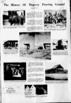
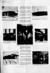
Show . TEST RUN, Friday, February 24, 1967 THE PONY EXPBESS wu organized in I860 to cany mail between St. Joseph, Missouri, and Sacramento, California. The entire operation wu organized in only sixty days. During this brief period, 90 stations were built and spaced 20 miles apart. About 400 horses and 80 riders were deployed along the trail. Each rider was expected to ride between 40 and 100 miles per day, changing horses every 10 miles or so. The route passed through Fort Laramie and Fort Bridger, Wyoming, to Salt Lake City and then across the Salt Lake Desert to the Deep Creek Mountains. Then it went across Nevada by way of Carson City and over the Sierras to Sacramento. On October 24, 1861, a continental telegraph line wu linked up at Salt Lake City, So, after only eighteen months of hard operation, the Pony Express wu discontinued. DURING THE 1930s, members of the Civilian Conservation Camp at Simpson Springs constructed numerous historical markers commemorating the sites of many of the Pony Express stations through this part of the state. The Overland Stage coaches began running in 1861 and continued until 1869 when the railroad wu completed. The trail followof the Overland Stage began in St. Joseph, Missouri, and Sacramento. to Nevada and Utah route ed the Pony Express through TUi li a picture of FJre Station No. 1. It wu one of the original buildingi constructed in Ditto Area in IMS. Mr. Guy Brown wai the fire m at this time and is still a nhrr of the department Today, file building is being used by Photographic Branch for a supply area. highThe old Lincoln Highway wu the first coast route turned south The in our original for motorists country. way from Salt Lake City, passed through the town of Tooele and joined the Pony Express route at the base of lookout Pass. After passing between Davis and Simpson Mountain, it left the Pony Express head-Trail, turned northwesterly, ran through Ditto Area and then This is a picture of the interior of die post headquarters building Wrtfd in Ditto Area in thf 40s. Notice the desksi these were called victory dedu for, on the inside of bach, there wu a small tag with a quote My work is done when this wu is won. i which wu located in the present This is the interior of the post cafeteria could eat here during the 50's. Division building. Everyone Comptroller . , w- -i mi Is this the Bowling Alley across the street from the Headquarters Company barracks? Nope! located in Ditto Area durIts the first bowling alley on Dugway - a giant sized three-lane- r ing the 50s. i ed down into Fish Springs Valley. After detouring around the swamp at Fish Springs on 20 miles of almost impassable road, it arrived at fire Fish Springs Station. Hie road then led through CallaoNev-at the- - western edge of the Desert, Gold Hill, and then to Ely, Lincoln Highway - Route 50 -ada and followed the present-da- y to the west coast. ' .i y a i THE OLD LINCOLN Highway had once brought hardy crosscountry motorists into this area but, with the completion of the improved U. S. Highway 40 across the Salt Flats to the north and U. S. Highway 6 to the south, this route wu abandoned. Travelers desiring to enter this area had to anticipate a rough trip. They , could come only via the dirt mountain roads across the mountains to the east through Johnson Pass, or Lookout Pass, which had been used by CCC personnel at Simpson Springs back in the 1930s, or on the unimproved road across Skull Valley used by the ranchers. u if in acknowledgement Railroads, too, skirted the area of its uselessness and desolation. The Western Pacific to the north and the Union Pacific to the east were both over 35 miles away. The name Dugway wu taken from the Dugway Mountains, the range west of the present Installation. The range, in turn, received its name during the Mormon migrations, when prairie schooners and covered wagons were used to transport personal The absence of roads and mountain passes effects made the pioneers use every ingenious means to get their wagons cross-countr- The photo In fiw old days, back in the 40s, this wu the Hospital. multi-winge- d building. shows a portion of the through. Their term dugway denoted a serpentine trench dug just wide enough to serve u a rut for the wheels on one side of the wagon. Ox teams, hitched at an angle to the wagon, pulled, towed and held the vehicle in its narrow rut. These dugways were the easiest method of negotiating the ascent over the mountains and, thus, gave their name to those slopes. This wu the Civilian Dormitory located in Fries Park during the early 50s. Today, this building is being used by Supply Division as a storage area. 'V! |