| OCR Text |
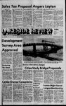
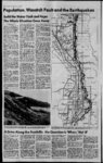
Show 8 V. Lakeside Hewew, Marc h 12, 1981 ton , Wasatch build the Water Tank and Hope The Whole Situation Goes Away m By MARILYN L. KARRAS ::: ' Attitudes Staff Writer of lawmakers and city Officials toward the possibility of a '.severe earthquake along the Wasatch IFtont, appear to be to hope the ;situation just goes away, according to a geologist with the U.S. Geological and Mineral Survey who has done an ex-- ; tensive study of the area, particularly Davis County. I;IThere have been some real lulus, Buce Kaliser said of recent decisions Howard building of public facilities lalong .the Wasatch Fault which runs along the foothills of the Wasatch ;Moun tains from Box Elder County through Utah County. He referred specifically to the Station of water storage facilities in ;Davis County and to legislation recently passed by the 1981 Utah Legislature to allow some public buildings, including schools, to circumvent building code restrictions designed to reduce earthquake and fire hazards. 'Weve learned so much about how to 'reduce damage from an earthquake by the placement of buildings on stable soil and by construction standards, but now tjie legislature seems to be headed backward its just incredible, Kaliser said. The bill, if approved by Gov. Scott Matheson, will set up a panel of individuals who will have the authority to ; approve exceptions to existing building Codes for public buildings. Homes would not be allowed the exceptions. - Building codes for schools should be r die strictest of all, Kaliser said. They should be planned for use as com- JntMnity shelters in case of a widespread emergency like an earthquake, besides Constructed to ensure safety of eBildren. kaliser said California has a separate '.law governing building of schools alone. Hg said the cost of building to and fire standards adds only about 2 percent to the cost of a school or other public facility. a rv extensive report, to be presented soon to a professional meeting of geologists, Kaliser has also outlined the location of water reservoirs and tanks in Davis County, which ho said almost exactly follow the fault ;jn Hdes. He said in many areas the water storage facilities are built on perched rock, unstable surfaces where rocks Vould probably fall downhill during an earthquake. - The water facilities are built in the foothills to give more pressure to the system, but Kaliser said much can be done to increase the stability of the facilities by placing them on good soil, and terrain which would be more likely to provide a more stable base in case of earthquake. Kaliser recalled an incident several years ago when officials of Farmington City asked him to study a site they were considering for a water tank. She said he determined it was the worst possible site and informed the city of his findings, but the decision was made to place the facility at that site anyway. You can just follow the formation of fault scarps by looking at where the water tanks are along the mountain, Kaliser said. Fault scarps are those areas where previous earthquakes have caused slippage along the fault. Future earthquakes could cause the tanks to collapse or to slide downhill, breaking water lines to cities, Kaliser said. Kaliser has also recently finished work on a map the first of its kind in Utah which designates areas in eastern Davis County, from North Salt Lake through South Weber, according to the susceptibility to earthquake. Color shading on the map, using orange, yellow, light and dark green, designate the areas where a major earthquake would cause most damage, (orange), the next most dangerous areas (yellow), and the areas least susceptible to earthquake tremors. , Surprisingly, the two areas in orange most susceptible to quake damage are located on the west side of Highway 89, away from the actual fault lines, and some of the least susceptible areas are very close to the fault zone, some directly above the fault fractures. The reason for the different designations, Kaliser explained, was that a number of other factors were considered, along with proximity to the fault zone. These factors which help determine how stable a structure built in the area would be include depth of water beneath the surface, type of soil, depth to bedrock, contour of bedrock, surface topography, nature of rock. All the elements, considered together, determine the probable .response of a particular site to a quake. Kaliser emphasized that the map may raise more questions than it answers. The two largest of the most susceptible areas are located in South Weber, along the Weber River bluffs and the Weber-Davi- s Canal, and in . HOMES BUILT along the foothills in eastern Davis County are often perched, like this one, along the Wasatch Fault Kaysville, between Crestwood Road and Mutton Hollow Road and immediately south of Crestwood Road east of about 700 East. The map completed by Kaliser is pari of a larger county-wid- e study involving a look at the effects of a possible earthquake on forest and mountain lands and wildlife. Kaliser said the fault zone itself varies from 1,000 feet to between 2 and 3 miles wide, primarily on the east side of Utah 89, but with some fault lines on the west. originate from one to earths surface, migrate north or south from the quake epicenter, Kaliser said. He said Davis County would experience basically three types of effects from the quake: Slope movement, liquefaction and ground movement. Slope movement would .include landslides, falling rocks, and stuffing off of ravines. Many of the canyon areas in the foothills and mountains are designated as very susceptible to earthquake damage because of the probability of this type of movement. Liquefaction would likely occur where there is a ground water near the surface, mostly in the more flat western areas of the county, but also near springs in the foothills regions. That type of movement would include a settling where structures would actually end up considerable lower in the ground, though the surface would, in most cases, return to its original position. Ground movement in an earthquake in Davis County could take several forms, depending on the local terrain and soil types, Kaliser said. He said Davis County and the rest of the Wasatch Front lies on a major divide of the continent, with the Rocky Mountain Province on the east and the Great Basin Province on the west. Because of this situation, its not surprising to find a major fault zone here. There have been no scientific predictions concerning when an earthquake might strike this area, Kaliser said. Nobody has the capability to say when it might happen, though the historical frequency of quakes in- dicates we may be due for one in the next 50 years, he said. We have no assurance we will get one that soon, but we have no assurance that we wont, he said. , Kaliser said state and local officials and residents should be preparing for the possibility. Earthquakes five miles beneath the and aftershocks would zone. In the event of an earthquake, landslides and earth movement could cause damage, geologists say. THE WASATCH FAULT, indicated in this diagram by heavy black marks, runs along the foothills in Davis County, primarily on the east side of Highway 89. The fault zone is from 1,000 feet to several miles wide. A Drive Along the Foothills: the Question Is 'When,' Not 'If' Z When geologists discuss the possibility of earthquakes along the Wasatch Front, the question is not if Ijiit only when. , - John Zippro, director of emergency services for Davis County, said a major earthquake is expected along the Wasatch Front in the next 50 to 100 years and could happen at any time. The situation is caused by unstable renditions deep within the earth and worsened by the fact that the Wasatch Front is the most densely populated portion of the state, with tens of thousands of people living and working iira concentrated area. motorist driving along the foothills frOm Tremonton in Box Elder County to Provo in Utah County would be tfaveling nearly directly above the nalural break within the earth which the causes the unstable situation WaSatih Fault. The fault runs parallel to the Wasatch A Mountains which lie along the east edge of Davis County, Weber County, Utah County and into Box Elder County,, between the foothills and the Great Salt Lake. The fault itself is the place where two layers of the earth have slipped because of movement and temperature change deep beneath the surface. The fault is very visible along the foothills in some areas, Zippro said. The slippage in Utah is a vertical slippage, compared to a horizontal slippage along tile San Andreas Fault in California, another unstable area where earthquakes are common. The vertical slippage would create a . landslide effect along the Wasatch Fault; in California, two portions of the earth would move back and forth, without making one area higher than the other. If a house sat directly on the fault line in Davis County, an earthquake could conceiv'ably split it into two portions, with one part ending up downhill from the other portion, Zippro said. Landslides would likely be created all along the foothills during a major quake, he said. However, most homes do not lie directly on the fault. A ripple movement out from the central area of the quake would probably be the motion felt by most residents, he said, but the movement would not be what many people visualize. People have been scared by the movies put out by Hollywood these disaster films, Zippro said. In the movies, an earthquake often opens up the earth and swallows entire buildings; this is not what actually happens. Zippro said that while fissures can be opened up in the earths surface by an earthquake, no huge holes are created to cause structures to disappear. The ground motion, more of a rocking sensation, would not be limited to within several hundred feet of the quake epicenter or along the fault itself, Zippro said. He compared an earthquake to the effect of a rock thrown into a pond, with large ripples near the point of impact, gradually diminishing farther away from the center. Everybody within miles of the epicenter would feel the movement, Zippro said. A Different types of soil also create different situations within the county. In some areas in the western portions of Davis County, homes are built on sandy soil which becomes soggy beneath the surface. An earthquake would cause a liquefaction process in those areas, he( said. He compared those areas to a bowl of jello in the way they would be affected by earthquake movement, homes in those areas would experience a settling motion, like a canister filled with flour and jolted against a flat, surface, Zippro said. - damage. Simply the fact that few major quakes have been felt in Utah in recent times causes geologists to be concerned. For many thousands of years, this area has been the site of earof vast proportions at fairly thquakes Structures built on rock would not regular intervals and is probably due settle in the same way and would for another. probably remain on the more solid Geological instruments in the surface of the earth. Less back and Wasatch Front area record about 1,000 forth movement would also be felt. earthquakes each year, Zippro said Most are not noticeable. ' A major earthquake, between 6.5 and 7.5 on the Richter Scale, could last up to three or four minutes and may be by some scientists to serve as t followed by several smaller, but still release for the tremendous tension damaging, aftershocks, Zippro said. which are believed to be buildinj Though the Wasatch Fault has not beneath the surface. Others say tin caused a large number of such major small earthquakes signal furthei quakes in the past 100 years, it did buildup of the constant pressure, whicl spawn a quake that measured b.7 on the will one day cause a powerful shift o s scale in the Logan area in the the earths layers and an earthouaki causing more .than $1 million in that could kill thousands. I L $ mid-1960- |