| OCR Text |
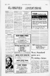
Show July 7, 1969 Page 3 OIL & MINING JOURNAL vicinity, Utah which is now offered for sale. These classic meanders of the Colorado about 4 miles above the confluence LOOP OF COLORADO RIVER is featured in this detail of U.S. Geological Survey map Canyonlands National Park and USGS offers Canyonlands map A new wall-siz- e topographic National of Canyonlands map Park and vicinity, Utah, has been published by the Geological Survey, Department Interior. of the The map covers miles of wild, 2,173 square rugged canyon country along the Colorado and Green rivers and embraces some of the most unusual natural formations in the United States. There are arches, needles, spires, and standing rocks; broad plains, steep scarps, bald mesas, and crenelated buttes; roaring rapids, placid reaches, sandbars, bits of multi-colo- r level bottom land, and dissected HOW'S THE MARKET? Dont ever ask Utah State Manager Frank Morgan that . . . how the market is. Chances are he doesnt know. Because the truth is he doesnt care. Why should I? he says. Let stock broken and their customers worry about market ups and downs. Tm selling lifetime investments. If someone buys funds from me today, I expect him not to look at the price till 1979. Funds need time. And which Rind does Morgan recommend? There are 800 funds, he replies. What I recommend depends on what an investors objective is. There never was was a time in the fund industry when advise-givin- g as much of an art as today. Frank Morgan phone 328-98- 9 State Manager S. Lind, Inc., Mutual Funds ISt la. 4th last, Aaknswhr Plasa. S.LC Ml 02, Saita b intricately tributary canyons. The map is published --at a time when the nation is observing the 100th anniversary of the pioneer exploration of the Colorado River by John Wesley Powell. Into this unexplored region in 1869 came Powell and hi 8 crew in four wooden boats-do- wn the Green and the heart of these Colorado-in- to Contour lines representing elevations at 80-fointervals take fantastic shape and form on the Canyonlands map, and reflect the excellence of modern ot cartographic technology. Wooded areas, trails, creek beds, public land lines, and administrative included. boundaries are the country. The Canyonlands National Colorful names describe the Park and Vicinity map was geography and formations, such compiled in 1969 from aerial as Orange Cliffs, the Needles, photographs and is published at White Rim, the Golden Stairs, the scale of 1:62,500 (1 in. Grand View Point, Bowknot represents approximately 1 Bend, Cataract Canyon and mile). It measures 46x61 inches, Fisheye Arch. Other names and is available at $1.50 per include: The Doll House, Teapot from the U.S. Geological Rock, Peekaboo Spring, All copy American Man, Calamity Mesa, Survey, Denver, Colorado Sweet Alice Canyon, Angel 80225, or Washington D.C. Arch, Island in the Sky, and 20242. Potato Bottom Mesa. - U.S. Steel halts big pipe production PROVO, large-diamet- er U shutdown tah--Th- e pipe mill at U.S. Steels Geneva TOC Canyonlands, to chart what was one of the least explored regions of the West. Powell noted in his Journal on July 17, 1869, upon reaching the confluence of the Green and Colorado (formerly the Grand) rivers: These streams unite in solemn depths, more than 1,200 feet below the general surface of Works will be shut down this week after one of the longest production runs since it was completed in 1955. Some 300 workers will be laid off. Geneva officials said the decline was caused by the in construction of petroleum pipelines and the intensified competition from imported pipe. An official said there were hopes of reopening, but no date was set. The mill produces pipe ranging from 24 to 40 inches in diameter. It had been running continuously since March, 1967. The in orders for pipe has been felt mills all the nation, the over by official said. Geneva also operates a smaller-diametlarge-diamet- drop er er production unit. |