| OCR Text |
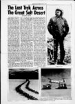
Show .t SALT FLAT NEWS, JULY, 1971 Great Salt Desert (from page 5) summers for it will be remembered that Edwin Bryant wrote that as he traveled across the flats, the mud gradually became softer, and our mules sometimes sunk to their knees. Perhaps this southwesterly course was set to avoid extremely mucky areas to the north. tions. His map does at the same time illustrate a sudden shifting to the north just before it reaches Silver Island (called Fire Island by Jefferson) and then takes it west to the Good water & Grass and the Bonark Wells that nestle beneath Pilot Peak (which Jefferson forgets to depict altogether). The map accompanying West from Fort Bridger corrects some of Jeffersons errors among the most important is that it shows Pilot Springs is not due west of Hastings Pus and at least starts the pioneers off in the right directi o n from the Cedar Mountains yet at the same time it creates some errors of its own, calling Floating Island, Crater Island and depicting the crossing of Silver Island farther south than was actually the case. And, of course, it does not show the great In any event just as the road begins to turn to the northwest, it of it suddenly divides, one-haWendover on toward continuing for a mile or so before swinging back and joining the other half. Perhaps here again exceptionally muddy conditions caused this diversion. Since most map makers have not personally investigated this terrain, the peculiar change of directions is not normally recorded; generally the road is depicted as streaking to the northwest as bend in the road toward straight as an arrow for Pilot Wendover. Dr. David E. Miller and his colPeak. Interestingly enough, one of the first maps ever published leagues first noticed this bend in concerning the Hastings 1956, but the weather was such Cutoff T. H. Jeffersons Map that they could not pursue it. The of the Emigrant Road from In- following year, Dr. Gerard S. dependence , Mo., to St Fran- Cautero and the present writer cisco, ' California (New York, managed to make the entire long 1849) makes something of the drive by jeep but were unable to same mistake as its successors and dock the actual distance of the shows the road stretching due bend because our mileage indicawest (rather than northwest) tor had broken. Nevertheless, from Hastings Pass in the Cedars. from evidence obtained from This would make the route run these and other trips, Dr. Miller south of the present highway was able to produce a relatively rather than north, a condition authentic map of the area, alcontrary to fact. Since Jefferson though still not giving enough is generally accurate In depicting prominence to the bend in questhe route in other areas, one is en- tion. The 1962 expedition in the couraged to conjecture that he Trackmasters and Spryte made it was so preoccupied in getting possible for our cartographer J. across the desert that he neg- Derle Thorpe, research engineer lected to make careful observa (Continued on page 7) lf Whole Earth Natural foods 1026 SECOND AVE. SALT LAKE CITY - ORGANIC FOODS STONE GROUND FLOURS SPICES GRAINS DRIED FRUITS ORGANIC PRODUCE RAW JUICE AND SANDWICH COUNTER HERBS SEEDS 224 SOUTH 1300 EAST cent VL Wok 363-496- 3 I , 8:00 A.M. - 8:00 P.M. MONDAY thru THURSDAY 8:00 A.M. - 6:00 P.M. FRIDAY & SATURDAY |