| OCR Text |
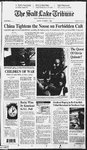
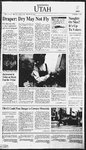
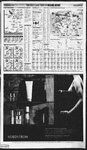
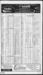
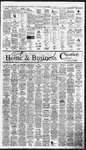
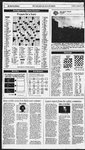
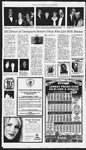
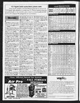
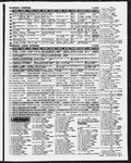
Show EFS SPER eS orLARE TRIBUNE WEATHERREPGRT Uiah Forecast °°"FerapetatredWigs onights ows i Taketowmiy 49/23/pc : abretipe‘i Wengow 62s: 6 ‘Tooele « ie Salt Lake} Cote ; Po Kebins/wV EamipaGorge Bae ° oeG/gc @ Vernal prevoloret Foosevelt Bia Roosevelt £1/26/s 67/37ipe 68/39/pc Delta cares : hi ie 67137h66 * Richfield 68/3Hs ° Capitol Reet NP. eee @ Ephraim een Price | World Today 64/34/s Utalvesterday” City 60/22/s ° Blanding 69/42/s @ Blanding Bountiful Brian Head Brigham City wyoeNP Capitol Reet edat City Coavile ita Duchesne Hi/Lo Prep 49/22 6330 61/29 55/11 5827 S6IIT 70/31 61/19 64/16 8/17 52/21 Oct31 Nov7 Moonsettoday Moonrise today Utah County Good Weber County Good Polien Index Statistics recordedatthe Intermountain AllergyClinic for yesterday, Ragweed /—]_ | | | | | | | Low Mod. | High |¥.High Teday’s UV Index” Higherindex numbersindicate greater ‘eye and skin exposure to Uttraviolet rays. ene ee oetee ee tah “gayore loab Provo” 6 67/39/s , «ParkCy] (58/2218 « Provo Vermal eease 58/260 Pri pluie Sonaie| oon © ois oot Vernal 61/28/s Thu (Park City ‘gar24ipe Provo’ ~Vernal« 62/37/pc 58/28/pc Price| Price} Sayep Sis eyes Bie ab * 68/26/s Suse Powell Aass Cysna ie7i4h jephi Ogden rem, Park City Payson Ploasant Gr. Price Provo a Richfield Roosevelt SaltLake Span. Fork Springville St George Toosle Vernal Wendover W Valley Zion Park 5/32 30 59/14 60/25 59/28 50/24 58/29 48/7 59/20 59/25 57/30 56/28 58/25 75/38 59/30 sa24 50/28 58/28 77/43 \ 2 Vw Mexico City Montreal Moscow Nairobi New Dethi Nuku'alofa 71/67 Panama Pans Rio de Guayma Honolulu 8i/67/pe 85/72 1 59/46. po P« pe pe S. Salvador 90/64 pc Sentiago eoul 56/52 6 Warsaw 54/48 c aa z alge Maza Loday’s Precipitation ; A r / Corn } 1 Suiirise/set™ Today Tonight Hi ee Bam noon 4pm Spm 7:87 am 6:26 pm prams oe Orlando Orle: ans18 86I7'Ipe TBI Miami 9 ear7é/sh Bermuda 7868/8 i A 5 Cancun Havana 8273) 87/7T4ipe ‘G0a)) 60s | 70s [esRR 1708| : RégionalCities” Major U:S’ Destinations Rain ge \t ¢ “g aE T-Storms 1 Snow a Ice ‘Shown are the noonpositionsof expected precipitation ‘4 2 owe Yesterday Today Yesterday Today Tomorrow o 68/47 65/45 § 62/31s Omaha 6445 Tr 69/43 s 64/298 HiLo Prop Hi/Lo W city HiLoPrep. Hilo W Hi/Lo W 77 722 sh 7042 sh Orlando 8364 86/71 pe 8470. 48/17 0.04 59/11 s Albany 66/34 67/47 pc 71/48 pc 71/50 5 73/54 pc Palm Springs 87/63 93/38. s S056 s Albuquerque 55/33 70/38 s_ 72/38s 63/34 76/24 s eas 748 s 6085S Phladene 72K8 74nd S| 7858 pe 2320 TH 231 po BAT pe 33 0.01 7/3 pe 8-1 pe Phoonix 8050 BAST s CHEZ eae 497200 Atlanta 733 72/87 po 75/551 66/39 74/48 s 73/50 pe 75/43 (74/52 po 74/48 62/27 68/36 s 74/49 74/57 pe 86/74 Tr 81/67 pc 81/69 pc Portland, ME 54/32 68/45 pc 63/46 po 6318 68/22 pe Atiantic City 70/89 70S8 078 6954 pe 78156 s 84/63 0.04 68/52 pe 74/525 Portland. OR 59/44 pe 67/415 56/22 62/90pe Austin Baltimore 7089 78/52.s 75/59 pe Indianapolis 7252. ¢ 72/41c Providence 61/40 70/48. s_70/52 pc 57/34 68/22 s Biings oso saa ¢ 4020 Jackson, MS 79/59 0.03 73/56 sh 71/54 pc Raleigh 76/41 76/51 5 75/58 pe 69/12 75/15 § 7856 po! 74/52'sh Kansas po Rapid 6983 «7285s 58/288 58/27 67/828 Bismarck 64/31 62/20 pc SONOS Las Ve 8 7030s 75/31 8 46/18 salt s 6836 57/90 pe 57/328 Like Frock r 71151 8 77/57 pc Idaho Falls 54/20 55/23 pe Boi Boston 57/42 74/558 72185 pe Los Angeles s 77/44 3 78/45 s Jackson Hole 46/16 45/10 pe Christn, SC 81/55 7659 pe 79/61 pc Louisville pe 71/60 c 69/44 pe Mesquite 83/46 7142s Chrisin, WY 7/42 76/48 pe 7/51 c Madison s 71/51 pe 79/49 s Missoula 67968 54/23 pe Chartotie” 7330 78/5T po" 74/88 ¢ 7360 75158.¢ A628 TTT 68/44 s * ral Page Cheyenne 5826 7031s 51/298 Miami 85/74 0.10 84/76 sh 6852 s 68508 59/25pe ‘Giah Opaates Pocatelio 57/25 Milwaukee ieago 7559 70/52 s 65/48 s 6327 s 62318 —74/50«—«74/55 pe 73/45 c Minneapoks 61/51 0.09 62/42 5 Rexburg 59/23 53/20pe Cincinnati 79/62 pe 79/61 pe Weather 524-5133, Sedona 76/42 83/36 s Cleveland 75/50 72/51 pe 72/45 Montgomery 8051 7852 c 54/38 sh 56/40 www sitrib.com 78/50 pc 77/58c Montpelier 55/29 63/44 po 64/45 pc SiouxFalls 62/38 «67/41. s 5G22S 65/42 Tr 55/30 pe Columbia, SC 74/44 RiverRecreation 539-1311 Spokane TAR2 pe c Nashville 7a48 75556 73E2C 7e42 7046-0 GAMA? ‘Sun Valley 67/90: 89/20 pe Columbus; OF ‘Avalanche 364-1581 TBA2 pe 71/46 pe New 78167 0.02 75/84 1 73/581 Tampa Se Tahoe 69/26 62/42 s ‘Air Quality 975-4003 gasd 7488s 74880 Trenion 7041 79/50 71/53 pc 72/55 0.96 6254 t 72/478 New York Twin Falls 63/28 59/32 pe Dallas Highway Conditions Dayton 7a82 72/54 pe 72/43c Norfolk 72! 7454's 74/59 p¢ Tucson 82/53 «BBAT s_ 94/535 Window Rock 60/14 7ali4 § ‘964-6000, (800)492-2400 6023 «7788s SA29s Oklahoma Ct ty 56! 52.068 GBS3 sh 738s Washington 71/48 74/56 873/54 pe 52/16 pe Denver National We Service Yellowsione 46/22 nimbo. wrh.noaa.govisaltlake Weather(W): s-sunny, pe-partly cloudy, ¢-cloudy, sh-showers, t-thunderstorms r-rain, st-snow flurries, sn-snow, i-ice. Prep -precipilation, Tr-trace city Aspen Boulder Butte Colo. Sprgs. Etko Evanston Flagstaft Gallup Grand Jet. cela oe mets YOUR BONUS WITH ANY PURCHASE OF (801) 922-42 00, Fashion Place, (B01) 261.4402 For order i Tom orrow’s Precipitation None ew YOURS WITH ANY PURCHASE rossroads Plaza, é Yesterday's National Extremes(in the 48 contiguous states) Low: 7 in Randoiph, Utah: High: 100 in Redlands, California 65/48 sh Singapore 87/76 sh Surejee.| Tehran 67/531 yO. 67/60 pe Vienna 61/50 pe] 92/75/ah Dallas 62/54/r ave [ tes [0s PUGRT] 10s [zeeFRR)40s {Moder Show 7/8 Lake;Powell alas y73/41/s = “foday’s Pollution [chenopods PRN) Cedar cif) Pehands are highs (oF day. con aEtonts Worale StationaryAang NS Nov 16 jNov2 2 pm 1 2.00 am Statistics recordedat the Utah Divish of Air Quality through6 pm yesterday Sait Lake/Davis counties Good Sagebrush \ Fronts os their noon sition. Tempers ¢@ Mf : ane Vake Sait CovDavis Co.ExtendedOutlook cB a3 ji yr "Asrble Price| Ble ffeld - ‘Today'sNorth America Forecast Stassieswoupm.ted A cold frontwill Utah ationalI Park approachfrom the Oran iow. andoiph north later today, then Utah highest procs 000 quickly pass through | Salt Lake Almanac the state tonight. This front will have limited | Sittitrough © pm yesterday Late Cryor ah moisture, only produc: | SatTotfa owe “O0230 ing patchycloudsin mo 0.02 138 the north alongwith Water year (Oct 110 date). 002 somegusty winds Departure trom normal 138 Tomorrow will be Thighvow noticeably cooler in the Record high Record tow north but only a little coolerin the south with Moon , a good deal of sun New First Full everywhere. 00:0R MORE answers or advico, call our Beauty Hotline at 1-800-7-BEAUTYor e-mail us at beauty@nordatrom.com |