| OCR Text |
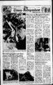
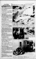
Show The Times-lndependen- Thursday, Feb. 24, 1983 t, BS Canyonlands National Park being mapped by USGS More than a century after John Wesley Powell pioneered exploration of the Colorado and Green rivers in southeastern Utah, the U.S. Geological Survey is gathering and data that will be used to produce new topographic maps of the popular recreation area. Powell, who served as the. second director of the USGS from 1881 to 1894, would probably be amazed at the sophisticated equipment now'being used by USGS surveyors and field assistants to confirm elevations and distances for the new, larger-scal- e maps. Most of the area being mapped in Utah is in Canyonlands National Park, with the remainder being private land in northwestern San Juan County and southwestern Grand County. Powell and other surveying parties set up camps on the river banks far from civilization, but this years USGS mapping crew is based in Moab, Utah, working out of offices and motels for day trips to field sites. In the old days our field camps were just that, including tents and explained USGS pack burros, District Cartographer Dick Mulder, in Denver, Colo., but with the advent of vehicles, motels and locally available office space, it is more convenient and economical to establish our field offices and living quarters in area towns and drive out to work each obtain measurements on foot or horseback. Todays USGS cartographers are not content, however, just to take electronic readings in easily traversed areas and drive away. They also spend many hours traveling over rough roads and trails to determine which should be classified as roads (passable by motorized vehicle) or trails, and if those trails are passable by people and animals. Before going to a field site, the field-checki- 19th-centu- cartographers study recent aerial photographs of the area to acquaint themselves with the terrain and cultural features (buildings, dams, etc.). In the field, aerial photos are compared to the actual landscape to confirm the features and determine their exact nature (bam, house, school, etc.). Any changes or deletions are inked on the aerial photos, which are sent, along with the surveyors field notes, to the Surveys mapping center in Denver. There cartographers use the information to etch the appropriate symbols into mylar sheets that are used to print the maps. This process may take from .one to five years, depending on the complexity of the map and whether it involves creating an entirely new map or merely revising an existing map. The topographic maps produced from the field work will be useful to private landowners, hikers, prospectors and other backcountry explorers, as well as local and regional planners who need accurate, detailed maps of the area. Mulder stressed that the USGS mapping project is strictly for the use of the standard Survey in producing topographic maps, and not for, or in any way connected with, any private industry. This is the first time the area has been mapped at a scale of 1:24,000 (one inch on the map represents about 2,000 feet on the ground). The area was previously mapped at scales of 1:62,500, 1:00,000 (metric), and 1:250,000. Not only does the earlier mapping need to be updated, said Mulder, but on the 1:24, maps (popularly known as quadrangles) features can be shown at a much larger scale and in greater detail than on the smaller-scal- e maps. In fact, when the new 000-sca- le 7.5-minu- te . maps are available, individual ranch houses will be shown, as well as shelter outbuildings, windmills, structures and campgrounds. Springs, wells, stock tanks, mines and old prospect holes also will be depicted. The various types of roads and trails will be designated by different colors and solid or dashed lines on the maps. The first maps produced from the 1983-8- 4 n work should be available from USGS sales outlets by late 1986. Information on currently available maps of Canyonlands and other areas of Utah should be directed to the Surveys National Cartographic Information Center (NCIC), Rocky Mountain Mapping Center, Mail Stop 504, Box 25046, Denver Federal Center, Denver, Colo., 80225, telephone field-seaso- 303-23- 4- ry 2326; the USGS Public Inquiries Office, 8105 Federal Bldg., 125 South State St., Salt Lake City, or 84138, telephone the USGS Utah State Affiliate Office, Utah Geological and Mineral Survey, 606 Black Hawk Way, Research Park, Salt Lake City, Utah 84108, telephone During their stay in Moab, the USGS mappers are available to talk to civic groups and interested individuals about their work and the 2; Surveys mapping program. Inquiries may be directed to the project office at P.O. Box 178, Moab,. Utah 84532, or to Mulder at the Surveys Rocky Mountain Mapping Center in Denver at Mail Stop 509, Box 25046, Denver Federal Center, Denver, Colo., 80225, telephone ve day. A helicopter is used to transport - crew, members to areas that are difficult or impossible to reach by land vehicles. Project supervisor Ed Eckel and cartographic technician Larry Moore from the Surveys Rocky Mountain Mapping Center in Denver, are working their way along ranch roads and desert trails, through rocky ravines and up steep slopes to locate USGS benchmarks, determine elevations, measure distances, verify occupied and abandoned structures and locate public-lan- d survey (section) markers. Moab residents Denise DAgnese and Sterling Bock are temporary field assistants on the gft project. Unlike Powell and other early-da- y surveyors who measured distances with a rod and chain and shot elevations with a transit, todays USGS mappers use sophisticated optical and electronic devices such as theodolites and electrotapes to measure horizontal arid vertical distances. The theodolite measures vertical and horizontal angles and the electrotape uses microwaves to measure distances, making it possible for the surveyors to obtain fast, accurate measurements in areas where it would have taken Powells men weeks or months to JEANS MENS LEVI'S BODYSUITS OR SHORTS FOR LADIES We have a blanket to suit you every need. Choose from a selection of plaids, solids and floral designs in a wide array of colors. denim jeans that won Classic shrink-to-f- it the west! Boot cut and straight leg styles in Extra long slightty higher. sizes 27-4- Activewear just in time for Spring savings! Stretchy bodysuit leotards to wear by themselves or with our sporty nylon shorts. Solids and stripes. SHEET SETS ; 8J7 TWIN 1277 15J7 FULL Mental Health QUEEN group organized Grand County d The Mental Health Association held an organizational meeting Monday, Feb. 21, in the city council chambers of the courthouse. were accepted and Bylaws committees set up to' assist the association in meeting its goal of providing education on mental health. Officers were elected in January, including Dick Thurston, president; Penny Lawton, Patricia Plas tow, secratary, and Cynthia Smith, treasurer. Two committees were set. and Education and Public-tBarbara Hargis of the Education Committee announced that the issodation has speakers and films tvailable for schools and service rganizations in the county. For ichedulirig and information, she can e contacted at 7 during the evenings. Other lay or nembers of the committee include udy Carmichael, Pam Wylie, and Pendleton. dichaelene Cynthia Smith was selected as a member of he Finance Committee. Association members can be nntacted for additional information, lie next meeting is set for March 21 n the council chambers, beginning it 7:30 p.m. All interested persons ire invited to attend. newly-forme- vice-preside- up-Inan- ce ; Di . Fancy patterns and pring ts highlight these beautiful muslin sheet sets which include a flat and fitted sheet plus pillow cases. Weve got it all ...at one low price. a'' . REG. TO dJ 14.99 LADIES CORDUROY PANTS We have a large assortment of corduroy pants in various styles and colors. These fashionable pants are comfortable fitting and washable. Sizes 5-1- MENS & LADIES PRE-WAS- H Plenty of pocket stitching occents these al cotton jeans in styles for him or her. Pick a pair 28-3thats perfect for you! Ladies 8. y. 259-612- 259-558- 9, . Driver killed in 170 accident The driver of a 1978 Datsun rollover was killed in a one-c25 miles east of accident on Thompson, Sunday, Feb. 20, at 8:30 a.m. Two passengers in the car escaped with minor injuries. All three were members of the U.S. Navy from San Francisco. One of the passengers, told investigating highway patrol troopers that the driver, Neal Roscoe Suydam, 19, was pointing out something in the Book Cliffs when the car drifted to the left and ran off the highway. Suydam apparently overcorrected and the car crossed both lanes of traffic, left the to the right and pavement overturned 2 34 times, ejecting Suydam, who was apparently killed on impact. Passengers Robert L. Crown, 21, and Charles R. Burke, Jr., 22, were transported to Allen Memorial Hospital by Grand County ambulance, where they were treated and released. The car was a total loss. B-2- 10 ar . . i 9.99 MENS FLANNEL SHIRTS These flannel shirts will provide the lightweight warmth you need for all your activities. Choose from assorted colors and plaids. Sizes OPEN DAILY 9:00-9:0SUNDAY 0 Prices effective Monday, February m REG. 4.99 BASEBALL JERSEYS Mens bcnebal jerseys give you comfort for al you sports acttvttie. COMFORT KNIT SHIRTS Mens assorted poty cotton shirts, in stripes & sokas. Sizes i PANTS ft JEANS FOR MEN can treat yourself to more than one pair h of these cords, denims or at this sale price! Plain and fancy pockets. Sizes 28-3You pre-was- 8. fmm "WHERE EVERYONE SAVES EVERYDAY! JEANS . |