| OCR Text |
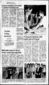
Show THE SENTINEL Paqe 2 Thursday, Jan. 26, 1984 NOTICE OF PUBLIC HEARING A public hearing before the West Jordan City Council will be held on February 14, 1984, at 8:00 p.m. in the West Jordan City Council Chambers, 1850 West 7800 South, West Jordan, Utah, for the purpose of receiv- ing public comment prior to considering an ordinance the Hanover-LantruProperty located at 6770 approximately South Redwood Road, from zoning classificato tion VOTED ON BY THE st Casady and Jon Tholen of Midvale are running for the offices of president and vice president of the Associated Students of the University of Utah. Two local young men seeking U of lwo local young men nave announced their candidacy for the offices of president and vice president of the Associated Students of the University of Utah. Forming the "victory" party are Kelly Casaday and Jon Tholen, both of Midvale. Casaday was the studentbody president of Hillcrest High School in 1980. After attending the University of Utah for a year he served an 18 month mission to Virginia for the IDS church. Currently he is a junior studying political science. Tholen also was active at Hillcrest High School where he was junior class president and a Sterling Scholar candidate. He served an 18 month mission to Switzerland and is now studying business and law. A campaign fund raising dance will be held tonight, Jan. 26, at 8 p.m. in the Union Ball - U offices room of the university of Utah Ophlin Union Building. Music will be provided by "Good Vibrations" mobile music and light. All are welcome to attend, a $2 donation is requested. Others running for the A.S.S.U. Assembly on the Victory party ticket are Steve Thayer, Anthony Layfe, Stewart Tholen, Lanny Howe, Brad Saunter, John Kunkler, Wes Meier, Maralisa Robertson, Sanjay Sutar, Gordon Jack, Kim Tryner, Kevin Jones, Todd Christianson and Jeff Nielsen. Campaign manager is Ron Nielsen and he is assisted by Gary Findley, Kurt Sorenson, James Able, as well as a host of others. The party platform has plans for better education, increased student involvement, wiser use of student funds, and better parking services. Public Notice Advertising Protects Your Right to Know NOTICE TO CREDITORS Estate of RICKEY DELMARMAYNARD, RICK DeceasMAYNARD, ed. Probate No. D84-2- aka signed or to the Clerk of the Court on or before the 1st day of or said 1984, May, claims shall be forever barred. STANLEY A. MAYNARD 46 Cooper Street All persons having the claims against are estate above required to present them to the under Midvale, Utah 84047 8 DAVID V. MAYNARD 10882 Edenbrook Drive Sandy, Utah 84070 4 sNOLANJ.OLSEN OLSEN & OLSEN Attorneys for the Estate 8138 South State Street Midvale, Utah 84047 6 Publication to be in: JORDAN VALLEY SENTINEL (Pub. 126; 22, 9, 1984) Logan Salt Lake City Connie Rice City Recorder (Pub. Jan. NOTICE OF PUBLIC HEARING is hereby Notice given that a public hearing will be held before the , Bluffdale City Council February 14, 1984 at the Bluffdale Center, W. 14400 So., Bluffdale, Utah at 7:45 to consider p.m. amending the Bluff- dale City Zoning Ordinance Sections to allow and the or processing removal of top soil and gravel as a Conditional Use. 1984. s Tammi Houston Deputy City Recorder (Pub. Jan. 26, 1984) NOTICE OF PUBLIC HEARING Notice is hereby given that a public hearing will be held before the Bluffdale City Council February 14, 1984 at the Bluffdale Center, Community (Pub. Jan. 26, 1984) NOTICE OF PUBLIC HEARING A public hearing will be held on February 28, 1984, at 8:00 p.m. in the West Jordan City Council Chambers, 1850 West 7800 South, West Jordan, Utah, for 1850 W. 14400 S., Bluff- ' an Hanover-Lantru- J', ments on its own, or pursuant to policies established be or regional entities. These proposed elevations will also new bu for toeir: rates flood insurance premium the appropriate their ; contents and for the second layer of insurance on existing contents to whom: Pursuant to the provisions of 5 USC 605(b), the Administrator, . Federal the Director, Emergency Manage-authority has been delegated by deterthe proposed ment Agency, hereby certifies that a significant economic impact on a mination, if promulgated, will not have under, substantial number of small entities. A flood elevation determination if adopted by a Section 1363 forms the basis for new local ordinances which flood plain area. local community, will govern future construction within the unless and until The elevation determinations, however, impose no restriction the local community voluntarily adopts flood plain ordinances in accord with with Federal. these elevations. Even if ordinances are adopted in compliance build in the flood plain and do standards,the elevations prescribe how high to forms the basis for future not proscribe development. Thus, this action only local actions. It imposes no new requirement; of itself it has no economic and owners of real property in the City of Murray, Utah are Insurance Study and Flood encouraged to review the Preliminary Flood above. cited address Proposed base flood the at available Insurance Rate Map elevations along flooding sources studied in detail are shown on the flood studied in detail are: profiles in the study. The flooding sources Range of Base Flood Elevations If Depth in Feet Above Ground Elevation in Feet (NGVD) Source of Flooding 4239to4291 Big Cottonwood Creek 4253to4347 Little Cottonwood Creek (Pub. Jan. 19, 26, 1984) ordin- the ng st Jand pro- located at perty 4800 approximately West New Bingham Highway, from zoning classification toR-l-8- 26, 1984) 1850 WEST JORDAN CITY COUNCIL THIS 17TH DAY OF JANUARY, dale, Utah at 7:30 p.m. for determining whether ' the current fiscal year general additional 1,250.00, said funds to be placed in the Cemetery Budget. LeeG.Wanlass Mayor Community 0. Kelly budget fund should be increased up to an considering ance the of purposes receiving public comment prior to VOTED ON BY THE WEST JORDAN CITY COUNCIL THIS 17TH DAY OF JANUARY, 1984. s Tammi Houston Deputy City Recorder (Pub. Jan. 26, 1984) THE CITY OF WEST JORDAN, UTAH A Municipal Corporation "Ses ORDINANCE NO.460 AN ORDINANCE ; PROVIDING FOR THE ANNEXATION OF UNINCORPORAT- ED TERRITORY LOCATED AT APPROXIMATELY 1400 WEST NATIONAL FLOOD INSURANCE PROGRAM Proposed Flood Elevation Determinations AGENCY: Federal Emergency Management Agency ACTION: Proposed rule. 6785 SOUTH Passed by a vote of the City two-thir- Council of West Day of January, 1984. Dennis M. Randall NATIONAL FLOOD INSURANCE PROGRAM Proposed Flood Elevation Determinations AGENCY: Federal Emergency Management Agency ACTION: Proposed rule. SUMMARY: Technical information or comments are solicited on the proposed base flood elevations shown in your community's Preliminary Flood Insurance Study and Flood Insurance Rate Map. These base flood elevations are the basis for the flood plain management measures that the community is required to either adopt or show evidence of being already in effect in order to qualify or remain qualified for participation in the National (100-yea- r) Flood Insurance Program. DATES: The period for comment will be ninety (90) days following the second publication of this proposed rule in a newspaper of local circulation in the community. ADDRESSES: Study and maps showing the proposed base flood elevations and their delineation are available for review at City Hall, 5461 South State Street, Murray, Utah. Send comments to the Honorable Larell D. Muir, 5461 South State Street, Murray, Utah 84107. FOR FURTHER INFORMATION CONTACT: Dr. Brian R. Mrazik Chief, Risk Studies Division Federal Emergency Management Agency r) (100-yea- r) Mayor Attest: Tammi Houston Deputy City Recorder (Pub. Jan. 26, 1984) (100-yea- SlTechnkal 'information or comments are solicited on the proposed base flood elevations shown in your community s Preliminary Flood flood Insurance Study and Flood Insurance Rate Map. These base measures that the management flood the for basis plain elevations are the show evidence of bemg already in community is required to either adopt or effect in order to qualify or remain qualified for participation in the National Flood Insurance Program. DATES The period for comment will be ninety (90) days following the second publication of this proposed rule in a newspaper of local circulation in the commun(100-yea- Jordan, Utah, this 17th r) ity. ADDRESSES: flood elevations and their Study and maps showing the proposed base delineation are available for review at City Hall, 800 East 100 North, Sandy, U Send comments to the Honorable Lawrence P. Smith, 800 East 100 North, Sandy, Utah 84070. FOR FURTHER INFORMATION CONTACT: Dr. Brian R. Mrazik Chief , Risk Studies Division Federal Emergency Management Agency Washington, D.C. 20472 (202) 287-02- SUPPLEMENTARY INFORMATION: The Federal Emergency Management Agency gives notice of the proposed flood elevations, in accordance with Section determinations of base 87 Stat. 980, 110 of the Flood Disaster Protection Act of 1973 (Pub. L. which added Section 1363 to the National Flood Insurance Act of 1968 (Title 42 XIII of the Housing and Urban Development Act of 1968 (Pub. L. and 44 CFR 67.4(a). U.S.C. These elevations, together with the flood plain management measures required by Section 60.3 of the program regulations, are the minimum that are required. They should not be construed to mean the community must change any existing ordinances that are more stringent in their flood plain management requirements. The community may at any time enact stricter requireWashington, D.C. 20472 ments on its own, or pursuant to policies established by other Federal, State, (202) or regional entities. These proposed elevations will also be used to calculate SUPPLEMENTARY INFORMATION: the appropriate flood insurance premium rates for new buildings and their The Federal Emergency Management Agency gives notice of the proposed contents and for the second layer of insurance on existing buildings and their flood elevations, in accordance with Section contents. determinations of base 110 of the Flood Disaster Protection Act of 1973 (Pub. L. 87 Stat. 980, Pursuant to the provisions of 5 USC 605(b), the Administrator, to whom which added Section 1363 to the National Flood Insurance Act of 1968 (Title has been delegated by the Director, Federal Emergency authority XIII of the Housing and Urban Development Act of 1968 (Pub. L. ), 42 Agency, hereby certifies that the proposed flood elevation Management U.S.C. and 44 CFR 67.4(a). determinations, if promulgated, will not have a significant economic impact These elevations, together with the flood plain management measures on a substantial number of small entities. A flood elevation determination required by Section 60.3 of the program regulations, are the minimum that are under Section 1363 forms the basis for new local ordinances, which, if adopted required. They should not be construed to mean the community must change by a local community, will govern future construction within the flood plain any existing ordinances that are more stringent in their flood plain managearea. The elevation determinations, however, impose no restriction unless and ment requirements. The community may at any time enact stricter require- - .until the local community voluntarily adopts flood plain ordinances in accord ' with these elevations. Even if ordinances are adopted in compliance with Federal standards, the elevations prescribe how high to build in the flood plain and do not proscribe developmentThus, this action only forms the basis for future local actions. It imposes no new requirement; of itself it has no economic impact. Lessees and owners of real property in the City of Sandy, Utah are encouraged to review the Preliminary Flood Insurance Study and Flood Insurance Rate Map available at the address cited above. Proposed base flood elevations along flooding sources studied in detail are shown on the flood profiles in the study. The flooding sources studied in detail are: Range of Base Flood Elevations H Depth in Feet Above Ground Source of Flooding 'Elevation in Feet (NGVD) 4305 Jordan River 4301to4595 Dry Creek Willow Creek 4591to4973 (Pub. Jan. 19, 26, 1984) (100-yea- r) 4001-412- 8, 0 (100-yea- 4001-412- 5 NATIONAL FLOOD INSURANCE PROGRAM Proposed Flood Elevation Determinations Federal Emergency Management Agency AGENCY : ACTION: Proposed rule. SUMMARY: Technical information or comments are solicited on the proposed base flood elevations shown in your community's Preliminary Flood Insurance Study and Flood Insurance Rate Map. These base flood elevations are the basis for the flood plain management measures that the community is required to either adopt or show evidence of being already in effect in order to qualify or remain qualified for participation in the National Flood Insurance Program. (100-yea- r) (100-yea- r) jjjjj Richfield DATES: The period for comment will be ninety (90) days following the second publication of this proposed rule in a newspaper of local circulation in the Cedar City community. ADDRESSES: Study and maps showing the proposed base flood elevations and their delineation are available for review at City Hall, 12891 South 1700 West, Riverton, Utah. Send comments to the Honorable Dale Farr Gardiner, 12891 South 1700 West, St. George Riverton, Utah 84065. FOR FURTHER INFORMATION CONTACT: Dr. Brian R. Mrazik Chief, Risk Studies Division Federal Emergency Management Agency Washington, D.C. 20472 (202)287-023- 0 Mountain Bell means long distance in Utah. Our separation from AT&T hasn't limited our service to just your town. Now and in the future, we're providing long distance service throughout Utah within the boundaries of something known as a LATA. What's a LATA? LATA stands for Local Access and Transport Area. Simply put, it's the area where we provide long distance service. In Utah, there is one LATA which generally follows the state boundary. That means that you can call most anywhere, any time in Utah using Mountain Bell's service. It's easy. Just as always, dial 1 the number for direct-diale- d calls. calls and 0 the number for all Operator-assiste- d The Mountain Bell advantage. Because it's so easy to dialour long distance service offers convenience that's second to none. But most importantly, our more than 100 years of telecommunications experience stands behind every call you make. So you'll always enjoy the kind of quality, reliable service you've come to expect from us. For more information about our long distance service and phone e Let's Talk number. Find out how system changes, please call our our continuing commitment to excellence means the very best in phone service Mountain Bell in town, and throughout your state. toll-fre- 2 (A) Let's Talkabout change: 1 800 555-500- : ; a - ' SUPPLEMENTARY INFORMATION: The Federal Emergency Management Agency gives notice of the proposed determinations of base flood elevations, in accordance with Section 110 of the Flood Disaster Protection Act of 1973 87 Stat. 980, (Pub. L. which added Section 1363 to the National Flood Insurance Act of 1968 (Title XIII of the Housing and Urban Development Act of 1968 (Pub. L. 90448)), 42 (100-yea- r) These elevations, together with the flood plain management measures required by Section 60.3 of the program regulations, are the minimum that are required., They should not be construed to mean the community must change any existing ordinances that are more stringent in their flood plain management requirements. The community may at any time enact stricter requirements on its own, or pursuant to policies established by other Federal, State, or regional entities. These proposed elevations will also be used to calculate the appropriate flood insurance premium rates for new buildings and their contents and for the second layer of insurance on existing buildings and their contents. Pursuant to the provisions of 5 USC 605(b), the Administrator, to whom authority has been delegated by the Director, Federal Emergency Management Agency, hereby certifies that the proposed flood elevation determinations, if promulgated, will not have a significant economic impact on a substantial number of small entities. A flood elevation determination under. Section 1363 forms the basis for new local ordinances, which, if adopted by a local community, will govern future construction within the flood plain area. The elevation determinations, however, impose no restriction unless and until the local community voluntarily adopts flood plain ordinances in accord with these elevations. Even if ordinances are adopted in compliance with Federal standards, the elevations prescribe how high to build in the flood plain and do not proscribe development. Thus, this action only forms the basis for future local actions. It imposes no new requirement; of itself it has no economic impact. Lessees and owners of real property in the City of Riverton, Utah are encouraged to review the Preliminary Flood Insurance Study and Flood Insurance Rate Map available at the address cited above. Proposed base flood elevations along flooding sources studied in detail are shown on the flood profiles in the study. The flooding sources studied in detail are: Range of Base Flood Elevations Depth in Feet Above Ground Source of Flooding 'Elevation in Feet (NGVD) Jordan River 4322to4354 (Pub. Jan. 19, 26, 1984) . 0. : |