| OCR Text |
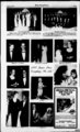
Show $mur CHoutttfl fftmttnr PAGES Legal Notices Continued From Page 4 MARCH 27, 1997 NOTICE TO WATER USERS Township boundary Township 27 South and Township 28 South, the East boundary line shall be the Range line between Range 9 West and Range 10 West, the South boundary shall be a line 3 miles South of and parallel to the Township line between Township 29 South and Township 30 South, and the West Boundary shall be the Range line between Range 12 West and Range 13 West, completely located in Beaver County, State of Utah. INTENDED IMPROVEMENTS ' The improvements to be constructed within the District in general include the 3 following: Heretofore. Published in the Beaver County Monitor March 20, and 27, 1 997. BEFORE THE DIVISION OF OIL, GAS AND MINING DEPARTMENT OF NATURAL RESOURCES STATE OF UTAH ooOoo IN THE MATTER OF TENTATIVE DECISION TO APPROVE THE MINING AND RECLAMATION PLAN FOR CENTURION MINES CORPORATION'S OK COPPER MINE, BEAVER COUNTY, UTAH NOTICE OF TENTATIVE DECISION TO APPROVE NO. 2. Grading, drainage, and surfacing improvements on: the diagonal road between the Laho Road and the Thermo Road. Said diagonal road is located in Sections 26, 27, 33, 34 & 35, T29S, R11W, SLB&M, and in Sections 3, 4, & 5, T30S, R11W, SLB&M. 3. Grading, drainage, and surfacing improvements and a new railroad on the Thermo Road from the M&M road to three miles west of the railroad. crossing The Thermo Road is located in Sections 3, 4, 5, 6, 7, 8, 9, & 10, T30S, R10W, SLB&M and Sections 1, 2, 3, 4, 5, 6, 7, 8, 9. 10, 11, & 12, T30S, RUW, SLB&M and Sections 1, 2, 3. 4. 5, 8, 9, 10, 11, & 12, T30S, R12W, SLB&M. 4. Grading, drainage, and surfacing improvements on a new road along the railroad tracks between the Laho Road and the Thermo Road. The new road will be located in Sections 29, 30, and 31 T29S, RUW. SLB&M. and in Section 36, T29S, R12W. SLB&M. and in Sections 1. 2. & 11. T30S, R12W. SLB&M. 5. Grading, drainage, and surfacing improvements on the Feed Mill Road from the feed mill to State Road 21. The Feed Mill Road is located in Sections 8. 9, & 17, T28S. R10W, SLB&M. 6. Widening, drainage, and surfacing improvements for turn lanes on State Road 21 at the Feed Mill Road intersection located in Sections 8 & 17, T28S, R10W, SLB&M. A map showing the location of the proposed improvements is on file and available at the offices of the County Clerk in Beaver, Utah during regular business hours and is attached to this Notice as Schedule 1. " MuU'"' w " " " b h.:i j m.G .ix METHOD NT AMUFraUiaraW. TirirwrfiriTiMi t l . ...i He Of OXTKW 3V0T"" Of -- -t o ' . m.aitt ooOoo TO ALL OPERATORS, TAKERS MINERAL OF PRODUCTION, AND ROYALTY OWNERS, AND 71-12- VUDIu-m'J- am The method under which the assessments are to be levied shall be as follows: MtthPd Pf Assessment Fsriimt Awwffi 20, 16 in well 410 deep (4) 1 1 38 E 1935 from SW Cor, Sec 21. 16 in well 560 ft deep (5) N 75 E 1600(6) N 1320 E 800 from S' Cor, 12 in well 450 ft deep (7) N 50 E 2130 from SW Cor, 16 in well 355 ft deep (8) N 48 E 662 from WA Cor, 16 in well 392 ftdeep (9) N 50 E 570 from SWCor, 16 in well 415 ftdeep (10) S 576 W 925 from NV4 Cor; Sec 28, 16 in well 585 ft deep (1 1) N 50 W 60 from SE Cor, 16 in well 360 ft deep (12) N 1710 W 50, 16 in well 500 ft deep (13) N 50 W 50 from E'A Cor, Sec 29, T28S, R10W.. 16 in well 543 ft deep USE: Irrigation: from Apr 1 to Oct 31 total acreage 959.60 acs, sole supply 881.60 acs; Stockwatering: 768 head of livestock; Dometic: 3 families. POU: S'jNE, non-tox- 8. Any person or agency aggrieved by this tentative decision to issue approval is hereby requested to submit written protest within thirty (30) days of the date of publication to Mary Ann wright, Associate Director of Mining, Division of Oil, Gas and Mining, 1594 West Norm Temple, Suite 1210, Box 145801, Salt Lake City, Utah 841 setting form factual reasons for the complaint. If do responsive written protests are received by the Division within 30 days after the last date of publication, the tentative decision of the Division will be final. Dated this 21st day of March, 1997 1, (previously mined) stockpiled copper ore surrounding the old O.K. Pit. The SXEW process produces a copper sulfate electrolyte which is pumped g cells where into 99.998 pure copper is electroplated The onto stainless steel sheets. copper ore is leached with a dilute sulfuric acid solution. Phasell - strip mining new' ore by widening and electro-winnin- WVS, ic 0. (SXEW) processing plant, and the and leaching of 2 million tons of NEKSWK, SWKNEK, S'2SE'4, NWSE'i, Sec 28; NE', E'2SE' Sec 29; N'jNWK Sec 33, 20; m extractkmelectro-winnin- g NWNE'A NE'JNW1, Sec 5-- PARTICULARLY ALL PERSONS INTERESTED IN SECTIONS 6 & 7, TOWNSHIP 27 SOUTH, RANGE U WEST, SLBM, BEAVER COUNTY, UTAH. Notice is hereby given by the Division of Oil, Gas and Mining of its to decision tentative approve Mines Centurion Corporation's Mining and Reclamation Plan for the OK Copper Mine. Mining activities will effect die following area: South Vt of Section 6 and Norm 'A of Section 7, T27S, R11W, SLBM, Beaver County, Utah. The operator will employ the following mining and reclamation techniques on approximately 275 acres of Private land. During Operationi: The mining operation will consist of three phases as follows: Phase I -construction of a fully lined (57 acre) heap leach pad, a (2 acre) solvent HERETOFORE: SE'4 After Operation: The heap will be rinsed with fresh water rinsate to comply with final effluent standards set by the State Division of Water Quality. Solution in ponds will be allowed to evaporate. Remaining sludge will be tested for metals and subjected to meteoric mobility analyses. All remaining hazardous material from these ponds will be disposed of at an appropriately licensed facility. Pond liners will be folded or dozed into die pond bottoms and covered with feet of fill. All dump slopes and heap leach pad slopes will be graded to 3H:1V, and covered with one foot of topsoil and Monitoring wells will be plugged according to state requirements. A water well will remain to source of water for local wildlife. provide a long-terThe processing facilities will be demolished and removed or buried onsite. Exposed concrete foundations will be broken up and buried. The process facilities area will be graded to blend with the adjacent topography and All materials will or be buried. Any remaining hazardous or toxic materials will be disposed of according to federal and state regulations. Approximately one foot of topsoil will be areas that originally had replaced on all disturbed, non-p- it topsoil. These areas will be roughened, terraced and reseeded with the approved seedmix to allow postmining use by livestock and wildlife. The person representing the company is Mr. Rick Havenstrite; Phone (801)534-112Centurion Mines Corporation if fulfilling obligations under the Utah Mined Land Reclamation Act of 1975, Utah Code Ann THE STATE OF UTAH ac-f-t. 3549.254 QUANTITY: SOURCE: Underground Water Wells tie following mining. M001039 Points) of (LEGEND: Diversion POD; Place of Use POU; Nature of Use USE) Jeffery L. (a20906): Wiseman, Lyle W. Wiseman, Scott T. Wiseman proposes) to change the POD of water as evidenced by 1287. 1288, 1844, 1845. 1887. 2004, 2005, 2006, 2007, 4492, and 4493. Laho Road from Grading, drainage, and surfacing improvements on located is Sections in The Road M&M to railroad. the Laho road west the 19, 20, 29, (13).POD:(l)N2315W35(2)N & 30, T29S. R10W. SLB&M and in Sections 20, 21, 22, 23, 24, 25; 26, 27, 28, & 29. 50 W 1350. 14 in. well 344 ft deep ' (3) N 70 W 120 from SE Cor, Sec T29S, R11W. SLB&M. ft N 1. leached. Phase III - development of the new eastern extension of the ore zone (Mary I pit). This pit will merge into the eastern side of the O.K. pit. All environmental permits will be in place prior to initiation of operations. Reclamation boodmg of mis operation will occur in phases. Approval of each phase will remain contingent on adequate pennitting and bonding for each phase. All process water will be contained in a fully engineered facility and all environmental controls will be in place prior to initiating leaching operations. Approximately 10 million tons of ore and 10 million tons of waste material will be produced. Variances were granted to allow pit high walls to remain at angles steeper than 45 degrees, and to allow the pits to impound water R10W. (Milford Flat Area) USE: Same as Heretofore. POU: Same as The State Engineer received to the following Appucation(s) Beaver in Water County Change NOTICE OF INTENTION (Locations in SLB&M). Persons objecting to an PUBLIC NOTICE IS HEREBY GIVEN that on the 17th day of March, 1997. the must file a Protest stating Board of County Commissioner of Beaver County, Utah (the "County"), adopted a application the reasons for the protest To have a resolution declaring its intention to create a special improvement district to be known as hearing before the State Engineer, Beaver County, Utah Special Improvement District No. 97-- 1 (the "District"). It is the persons must request a hearing in the intention of the Board of County Commissioners to finance the cost of certain road Protest Protest must be filed in improvements within the District and to levy a special assessment as provided in duplicate with the State Engineer, Title 17A. Chapter 3, Part 2, Utah Code Annotated 1953, as amended, on the real estate 1594 West North Temple. Salt Lake on lying within the District for the benefit of which such assessment is to be expended in City, Utah 841 14, (801)538-724- 0 or before APRIL 17. 1997. the making of such improvements. DESCRIPTION OF DISTRICT (PROTESTS MUST BE LEGIBLE WITH A RETURN ADDRESS). These are informal proceedings as The proposed District shall have the following boundaries: i t of the Division of per Rule R655-6-- 2 . Water Rights. line shall be the line between The North STATE OF UTAH DIVISION OF OIL, GAS AND MINING S James W. Carter T28S.R10W. Director . , u.uj. ..JHERAA.EJJB-AL,- , Published in Beaver.Coun March127f,J?9t Mppr 354fc254J tANTTfY: vrf6penin'g"he existing.,Q.K. pit.. Same as Heretofore, but adding the Overburden to ore NOTICE stripping ratio is Mowing: SOURCE: 16 in well 100 approximately 1:1. Run of mine ore The graduating class of 1 982 wishes to reserve ft to 500 ft deep. POD: ( 1 ) N 2635 W will be stacked on the heap and the Big Rock Picnic Area for Jury 5, 1997. Published in 285 from SE Cor. Sec 30. T28S, dL-BO- . (continued in next column) (continued in next column) the Beaver County Monitor March 27, and April 3, 1997 Road Improvements $550 Per Acre Acreage ESTIMATED COST OF IMPROVEMENTS The total cost of improvements in the District is estimated to be $3,710,000 of which the County shall pay $130,000, leaving the remaining $3,580,000 which shall be paid by a special assessment to be levied against the property which may be directly or indirectly benefited by such improvements which benefits need not actually increase the fair market value of the property to be assessed. The property owners' portion of the total estimated cost of the improvements may be financed during the construction period by the use of interim warrants. The interest on said warrants will be assessed to the property owners. The estimated cost of improvements to be assessed by connection against the lots within the District is as follows: ASSESSMENTS AND LEVY OF TAXES It is the intention of the Board of County Commissioners of the County to levy assessments as provided by the laws of Utah on all parcels and lots of real property within the District benefiting by the proposed improvements described herein. The purpose of the assessment and levy is to pay those costs of the subject improvements which the County will not assume and pay. The method of assessment shall be by acreage as set forth hereinabove. The assessments may be paid by property owners in ten (10) annual principal installments with interest on the unpaid balance at a rate or rates fixed by the Board of County Commissioners, or the whole or any part of the assessment may be paid without interest within fifteen (15) days after the ordinance levying the assessment becomes effective. The assessments shall be levied according to the benefits to be derived by each property within the District. Other payment provisions and enforcement remedies shall be in accordance with Title 17A, Chapter 3, Part 2, Utah Code Annotated 1953, as amended. A map of the proposed District and specifications of the proposed improvements and other related information are on file in the office of the County Clerk who will make such information available to all interested persons. TTMF. FOR FTIJNG PROTESTS Any person who is the owner of record of property to be assessed in the District described in this Notice of Intention shall have the right to file in writing a protest against the creation of the District or to make any other objections relating thereto. Protests shall describe or otherwise identify the property owned of record by the person or persons making the protest. Protests shall be filed with the County Clerk of Beaver County, Utah, on or before 5:00 p.m. on the 18th day of April, 1997. Thereafter at 1 :00 p.m. on the 21st day of April, 1997, the Board of County Commissioners will meet in public meeting at the County Courthouse to consider all protests so filed and hear all objections relating to the proposed District. After such consideration and determination, the County shall adopt a resolution either abandoning the District or creating the District either as described in this Notice of Intention or with deletions and changes made ai authorized in bylaws; but the County shall abandon the District and not create it if the necessary number of protests as provided herein have been filed on or before the time specified in this Notice of Intention for the filing of protests after eliminating from such filed protests: (i) protests relating to property or relating to a type of improvement which has been deleted from the District and (ii) protests which have been withdrawn in writing prior to the conclusion of the hearing. The necessary number of protests shall mean the Protests representing one-ha- lf of the acreage to be assessed where an following: assessment is proposed to be made according to number of acreage. BY, ORDER OF THE BOARD OF COUNTY COMMISSIONERS OF BEAVER COUNTY', UTAH Paul B. Barton bl Clerk Published in the Beaver County Monitor March 20, 27, April 3, and 10, 1997. p 1 -- " j ri l" : I -- r - -f Z P IaMrIlrmd- Jf- TPiT 1ffSf 1 S i-- mm . brH m I I rf m 1 A lv r-V- " 1 - . road. : iN.-l - V rr i L"jVlJ".5 L7l7 ' ANOLED jfOAO :rTBrWEPTUHOE ' iii -- Kn pa-- i j jsrj - i . RD. ' . ! , ; JSf '':fr V 'j; lyA ,T"tTT,"j ''i 'I aiairiiiBBiiiii Jii j i yT" ipnin ' " V i - JKApK pnwitflrtiwnif ! J- -j ; stcRb! fTftT&wl . - Uf.Rf h : re 1 i J- - i- " ' ' 1 j i " 1S11 i i I m ' ' ?'"yviij;'J- - ROADS TO BE IMPROVED Jones 45 Eost LOCATION & DeMflle Engineering 500 North RiehfM4 (601) 896-62- 86 (801) 896-82- 68 Voie Fox Utah BEAVER 84701 SCALE: NONt DATEl MARCH CN&: 1M7 MAP COUNTY K DW&BY IM. BXX S.I.D. 0J.ft M07-0- S0 DM.NAtft:rX15 |