| OCR Text |
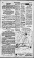
Show Srmirr (Eflwftg f&mitar PAGE 5 MARCH 20,1997 R10W. (Milford Flat Area) USE: Same as Heretofore. POU: Same as NOTICE TO WATER USERS Legal Notices The State Engineer received NOTICE OF INTENTION PUBLIC NOTICE IS HEREBY GIVEN that on the 17th day of March, 1997, the Board of County Commissioners of Beaver County, Utah (the "County"), adopted a resolution oc1ring its intention to create a special improvement district to be known as Beaver County, Utah Special Improvement District No. 97--1 (the "District"). It is the intention of the Board of County Commissioners to finance the cost of certain road taprovements within the District and to levy a special assessment as provided in Title 17A, Chapter 3, Part 2, Utah Code Annotated 1953, as amended, on the real estate lying within the District for the benefit of which such assessment is to be expended in the making of such improvements. ' DESCRIPTION OF DISTRICT The proposed District shall have the following boundaries: Monitor March 20, and 27, 1997. Before the Board of Oil Gas and Mining Department of Natural Resources in and for the State of Utah . The improvements to be constructed within the District in general include the Water Rights. (LEGEND: Points) of Diversion POD; Place of Use POU; Nature of Use USE) (a20906): Jeffery L. Wiseman, Lyle W. Wiseman, Scott T. Wiseman proposes) to change the POD of water as evidenced by 71- 1245, 1287, 1288, J844, 1845, 1887, 2004, 2005, 2006, 2007, 4492, and 4493. 71-12- HERETOFORE following: 1. Grading, drainage, and surfacing improvements on the Laho Road from the M&M road west to the railroad. The Laho Road is located in Sections 19, 20, 29, & 30, T29S. R10W. SLB&M and in Sections 20, 21, 22, 23, 24, 25, 26, 27, 28, & 29, T29S, R11W, SLB&M. 2. Grading, drainage, and surfacing improvements on the diagonal road between the Laho Road and the Thermo Road. Said diagonal road is located in Sections 26, 27, 33, 34 & 35, T29S, RUW, SLB&M, and in Sections 3, 4, & 5. T30S, R11W, SLB&M. 3. Grading, drainage, and surfacing improvements and a new railroad crossing on the Thermo Road from the M&M road to three miles west of the railroad. The Thermo Road is located in Sections 3, 4, 5, 6. 7. 8. 9, & 10, T30S, R10W, SLB&M and Sections 1, 2. 3, 4, 5, 6, 7, 8, 9, 10. 11, & 12, T30S. R11W. SLB&M and Sections 1, 2, 3. 4. 5, 8, 9, 10, 11, & 12, T30S, R12W, SLB&M. 4. Grading, drainage, and surfacing improvements on a new road along the railroad tracks between the Laho Road and the Thermo Road. The new road will be located in Sections 29, 30, and 31 T29S, R11W, SLB&M. and in Section 36. T29S. R12W. SLB&M, and in Sections 1. 2. & 11. T30S. R12W. SLB&M. 5. Grading, drainage, and surfacing improvements on the Feed Mill Road from the feed mill to State Road 21. The Feed Mill Road is located in Sections 8, 9, & 17, T28S, R10W, SLB&M. 6. Widening, drainage, and surfacing improvements for turn lanes on State Road 21 at the Feed Mill Road intersection located in Sections 8 & 17, T28S, R10W, SLB&M. A map showing the location of the proposed improvements is on file and available the offices of the County Clerk in Beaver, Utah during regular business hours and is at attached to this Notice as Schedule 1. METHOD OF ASSESSMENT The method under which the assessments are to be levied shall be as follows: Method of Aaimffimem Fmn Aliment within the District benefiting by the proposed improvements described herein. The purpose of the assessment and levy is to pay those costs of the subject improvements which the County will not assume and pay. The metbod of assessment snau oe oy acreage as jet forth hereinabove. The assessments may be paid by property owners in ten (10) annual principal insuUlments with interest on the unpaid balance at a rate or rates fixed by the Board of County Commissioners, or the whole or any part of the assessment may be paid without interest within fifteen (15) days after the ordinance levying the assessment becomes effective. The assessments shall be levied according to the benefits to be derived by each property within the District. Other payment provisions and enforcement remedies shall be in accordance with Title 17A, Chapter 3, Part 2, Utah Code Annotated 1953, as - Disabilities ' act, requiring persons auxibary communicative aids and services to enable them to participate in this hearing should call Christine Allied at 538-532- 7, at feast three working days J Published in the Beaver Monitor March 20, 1997 i 'i i - Year Subscription Regularly $35 - $25 with coupon only! Beaver County Monitor Phone ! j r Fax:801-387-552- - u --4 4 YU-- I -- w r jjtef irrrrrz : J rW-X- j )T IfTft .: 1 ' 1 A - j " Trnrn ryTT5 J .i Aj - . " if I vfr ; i I - - r-- t"L r I 1 1 : -- Milford UT 8475 bh 1 i P. O. Box 224 450 N. 100 E. 76 J j HI r l ! j I H 1- 1 nTl 7r Protect Your Rights County COUPON SPECIAL , MJ.i - Legal Notices prior to the hearing. Psd- - N i. ! It is the intention of the Board of County Commissioners of the County to levy assessments as provided by the laws of Utah on all parcels and lots of real property - HEREAFTER: $550 Per Acre Acreage ESTIMATED COST OF IMPROVEMENTS Answer by: Jerry Goods peed, Utah State University Extension Horticulturist The arrival of seed catalogs in the mail and seed packets in garden centers gives us hope that spring is on its way. Now is a good time to start making plans for flower and vegetable gardens. When buying seeds, be certain to get the varieties known to perform well in your area. a list of Extension USU publishes recommended varieties for different locations. These varieties are tested for growth, flavor, Your local pest resistance and hardiness. what on also can grows tips give you nursery best in your area. Most seeds are grown in specific locations in the world, then brokered to seed companies. For example, a large majority of sweet corn seeds are grown in southwest Idaho. The seeds are then sold to companies who package them and send them to retailers. Although the name of the seed company is different on the package, the seeds often come from the same location. Be cautious when ordering seeds through the mail. Occasionally companies will advertise a rare variety and substitute a common variety in its place. This can be an expensive way to buy a variety you could have purchased at your local nursery. If you do purchase seeds through a catalog, be sure it is reputable. Since most people tend to over-bu-y vegetable seeds, keep in mind that they can be stored for next year and still produce viable plants. Place seeds in the original package in an airtight container such as a plastic bowl, a glass jar or a can. Be sure they are sealed tightly. Place tissue or paper towels in the container with powdered milk to absorb any excess moisture. Keep the container in a cool, dry place. 97-00- T28S.R10W. Road Improvements The total cost of improvements in the District is estimated to be $3,710,000 of which the County shall pay $130,000, leaving the remaining $3,580,000 which shall be paid by a special assessment to be levied against the property which may be directly or indirectly benefited by such improvements which benefits need not actually increase die fair market value of the property to be assessed. The property owners' portion of the total estimated cost of the improvements may be financed during the construction period by the use of interim warrants. The interest on said warrants will be assessed to the property owners. The estimated cost of improvements to be assessed by connection against the lets within the District is as follows: ASSESSMENTS AND LEVY OF TAXES : ac-3549.254 QUANTITY: SOURCE: Underground Water Wells (13). POD: (1)N2315W35(2)N 50 W 1350, 14 in. weliT344 ft deep (3) N 70 W 120 fiom SE Cor, Sec 20, 16 in wdl 410 ft deep (4) N 1138 E 1935 from SW Cor, Sec 21, 16 in wdl 560 ft deep (5) N 75 E 1600 (6) N 1320 E 800 from S'4 Cor, 12 in well 450 ft deep (7) N 50 E 2130 from SW Cor. 16 in well 355 ft deep (8) N 48 E 662 from WA Cor, 16 in well 392 ft deep (9) N 50 E 570 from SW Cor, 16 in well 415 ft deep (10) S 576 W 925 from NV4 Cor, Sec 28, 16 in well 585 ft deep (1 1) N 50 W 60 from SE Cor, 16 in well 360 ft deep (12) N 1710 W 50, 16 in well 500 ft deep (13) N 50 W 50 from E Cor, Sec 29, T28S, R10W., 16 in well 543 ft deep USE: Irrigation: from Apr 1 to Oct 31 total acreage 959.60 acs, sole supply 881.60 acs; Stockwstering: 768 head of livestock; Dometic: 3 families. POU: S'iNE'i, NWXNE'A NEKNWVi, NE'SWV4, SE' Sec 20; WA, SWKNEM, S'jSE', NWKSEK, Sc 28; NE', EKSEK Sec 29; N'jNW'i Sec 33, QUANTITY: 3549.254 ac - ft POD; Same as Heretofore, but adding the Mowing: SOURCE: 16 in well 100 ft to 500 ft deep. POD: (1 ) N 2635 W 285 from SE Cor. Sec 30, T28S, (continued in next column) DO YOU HA VE TIPS FOR. BUYING SEEDS? The regular monthly meeting of the Board of Oil, Gas and Mining will be on Wednesday, March 26, 197, at 9:00 a.m. in the boardroom of the Department of Natural Resources, 1594 West North Temple, Suite 1040 A, Salt Lake City, Utah. The Briefing session conducted by the Division of Oil, Gas and Mining will begin at 9:00 am. The following items will be presented during the briefing session: 1 . Board Appointments 2. Earth Nomination Day Presentations 3. Five Year Rule Review 4. Changes in AML Rules 5. Stakeholders Meeting Agenda 6. Board Going Away Party 7. Other items as necessary 8. Next month's Agenda The following matters will be heard at 11:00a.m. 1. Docket No. Cause No. 167-- 8 In the matter of the request' for agency action of Union Pacific Resources, for an order establishing horizontal drilling and spacing units for the Twin Creek Formation located in Sections 2,3,4,9,10 and 11, Township 2 North, Range 7 East, and Section 34, Township 3 North, Range 7 East, S.L.B. & M , Summit County, Utah. 2. Twin Mountain Rock Company. Milford Ouarrv. M001036. Beaver County. Utah Request for Board form amount of Approval, reclamation surety. Pursuant to the Americans with -2 The North boundary line shall be the Township line between Township 27 South and Township 28 South, the East boundary line shall be the Range line between Range 9 West and Range 10 West, the South boundary shall be a line 3 miles South of and parallel to the Township line between Township 29 South and Township 30 South, and the West Boundary shall be the Range line between Range 12 West and Range 13 West, completely located in Beaver County. State of Utah. INTENDED IMPROVEMENTS mm Published in the Beaver County Locations in SLB&M). Persons objecting to an application must file a Protest stating the reasons for the protest To have a hearing before the State Engineer, persons must request a hearing in the Protest Protest must be filed in duplicate with the State Engineer, 1594 West North Temple, Salt Lake on City, Utah 841 14, (801)538-724- 0 or before APRIL 17, 1997. (PROTESTS MUST BE LEGIBLE WITH A RETURN ADDRESS). These are informal proceedings as of the Division of pa Rule R65 as n Heretofore. the following Application) to Change Water in Beaver County " " h . r--A 7 -- ! j u . - T n5Cndeft"map of the proposed District and specifications of the proposed improvements and other related information arc on file in the office of the County Clerk who will make such information available to all interested persons. TIME FOR FILING PROTESTS Any person who is the owner of record of property to be assessed in the District described in this Notice of Intention shall have the right to file in writing a protest against the creation of the District or to make any other objections relating thereto. Protests shall describe or otherwise ideaify the property owned of record by the person or persons making the protest. Protests shall be filed with the County Clerk of Beaver County, Utah, on or before 5:00 p.m. on the 18th day of April, 1997. Thereafter at 1:00 p.m. on the 21st day of April, 1997, the Board of County Commissioners will meet in public meeting at the County Courthouse to consider all protests so filed and hear all objections relating to the proposed District. After such conskleration and determination, the County shall adopt a resolution either abandoning the District or creating the District either aa described in this Notice of Intention or with deletions and changes made as authorized in bylaws; but the County shall abandon the District and not create it if the necessary number of protests as provided herein have been filed on or before the time specified in this Notice of Intention for the filing of protests after dinutating from such filed protests: (i) protests relating to property or relating to a type of improvement which has been deleted from the District and (ii) protests which have been withdrawn in writing prior to the conclusion of the bearing. The necessary number of protests shall mean the lf of the acreage to be asseased where aa Protests representing following: assessment is proposed to be made according to number of acreage. BY ORDER OF THE BOARD OF COUNTY COMMISSIONERS OF BEAVER ROADS one-ha- COUNTY, UTAH tiL Paul B. Barton Clerk Published in the Beaver County Monitor March 20, 27, April 3, and 10, 1997. Jones 43 Cost LOCATION UAP & DeMflle Engineering 500 North (801) B96-62- &S (aoi) 896-B2- B8 RiehfMd. Utah TO BE IMPROVED BEAVER 84701 COUNTY Vole Fe SCAX N0NC B1C MARCH CM9.: 1M7 MOB SJ.D. KIM. tlX omNMatrx-- ia |