| OCR Text |
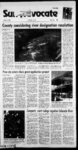
Show 11 rri nf9Ptvwft99 Til it i'll "' ri - Tuesday sniiiHueiffAicuaiiw dm iasswaisB swwiuaasiMEJ99airi' ssvidc-- - aBuwiiBUWt srautiw inf,rrri!TiR,,inBT?ir?PT,nj J 83 111th Year-N- o. October 15, 2002 Price, Utah r rZfr-'W!- State victory eludes Vikings, IB 500 ,v. ; .v vV ' , County considering river designation resolution people on the wild and scenic rivers designation program being processed by the BLM. The process leading to one of the three designations begins with an eligibility and classifica- By RICHARD SHAW Staff reporter In 1968, the United States Congress passed the Wild and Scenic Rivers Act. The federal legislation specifically named a number of rivers in the UJS. However, the act was passed to apply to additional waterways in the future and that has been happening. During the years since 1968, federal agencies have been waking on classifying more and more rivers as wild, scenic or recreational. Under the law, the designation is based on current use and rivers possessing remarkable scenic, recreational, geologic, fish and wildlife, historic, cultural or similar values. The original idea was to protect the rivers for future generations. But in the early stages of the r ". C'Vvlrr r ' .dL rv- .u, ' Jt-- - .. f 'r. ' ' a .44V - M " '41.. f. - -Atr. y- m v y'? t ' ' ' , r - ' in-du- de - : .m . ? , v ' - r s V- .. . J - j' . . V'S.? lb . ); ' r v r .y Jt fXr. 4 vi .XI laws implementation, funding was cut and the process slowed V considerably. The act recognizes dmee types of rivers for protection - wild, scenic and recreational. All three are protected from impoundment or water development that would harm the rivers . rZ- ' W-- ' V free-flowi- ng character. The distinction stems from the level of development that can be allowed along die river corridor. Wild rivers are the most pristine, generally accessible only by trail, and have undeveloped shorelines. Scenic rivers have shorelines Tin Price River is under study by the BLM in conjunction with federal legislation enacted in 1968 . Wild and scenic river proponents daim the designations have that are largely undeveloped, but may have some access by roads. Recreational rivers have more development and are easily accessible by road. Presently, the U.S. Bureau of Land Management recently started to study and classify riv- - tMeeffect on pad practkBii opponents contend tturtagreat deal can change, including the way private land around the classified streams can be used. ers and drainages in the Carbon- Emery County areas. Because of the federal agencys activfy, Car-bon commissioners selected tion stage. The Price River, some of its tributaries and other waterways in the local area are presently under the initial stage of the project. The two final phases suitability and dedication of the streams to a category. Based on a meeting and contacts with the BLM, Levanger and Sacco introduced a proposed resolution to the Carbon County Commission on Oct. 2 for adoption. The resolution specified that there should be no net loss of private ownership in acreage, volume of water or acreage. I am concerned about what can happen here, that is the reason for us proposing the resolution, explained Sacco. I am worried about how the rivers and streams will be classified. It could restrict use of the property by owners and it could also affect the water rights and the amount of water available. It could also create property tax problems. The commissioners talked about the situation and discussed the ramifications of the proposed Levanger and Rex Sacco from the resolution. I think we need to go ahead with this before it is too late, indicated Commissioner Mike Milovich. I worry about use and Geographic Information terns department as contact (Continued on page 3A) county building official Dave Sys-shorel- Price city selects block grant application project By KEN LARSON Sun Advocate publisher Gty engineer Gary Sonntag The public hearing in preparation to apply for2003-200-4 community development block grant funding was conducted at the Price City Council meeting Oct 9. The hearing was called to consider potential projects which funding may be applied under the block grant program. The grant money must be spent on projects benefiting low and moderate income persons. Price community director Nick Thtton suggested officials lookat funding a mapping tytem to identify specific areas and assets of thie dty, especially areas such as utilities. The hardware would be helpful in mapping and tracking dty services. The Southeastern Utah Association of Local Governments, of which Price Municipal Corporation is a member, expects to receive $39,154 in the new program. All eligible activities that can be accomplished under the program are identified in the CDBG application guide and interested persons can review it at any time. read information concerning the grant which indicated that potential projects that may be eligible fornmding. The projects included the construction of public works and facilities like food banks and homeless shelters or the development of loan programs for private businesses which would hire low income persons. The program can also pay for housing rehabilitiation for low income homeowners. Price officials approved the mapping service as the citys project tot the application. The dty has received grant money in the past fbrpcdcstnan safety sidewalk improvements, planning and design as well as Americans with Disabilities Act restroom construction. Price has included the citys capital investment plan as part of flw regional cpnffflwhltffd plan Councilwoman Elizabeth Kourianos reported on die shade tree commissions progress on the development of a memorial grove near Qifiview Cemetery. On Oct. 21, veterans groups have been invited to assist in planting trees donated by Utah Power to honor military person Price was awarded $640 in local law enforcement grant revenues, with a match of $760. Each camcorder will cost $3,800 through the Utah state bid. Severe leaking unexpectedly occurred on the boiler at the swimming pool a couple weeks ago. Several heating tubes were cracked and needed to be re- placed. R&L Boiler completed the repairs and billed the dty $4,629. The council approved the payment for the repair work. Councilman Richard Ihtton reported that die sign for Heritage Park is being waked on and two new programs are being pro- posed for die dty recreation department The programs indude trainvehide usage ing for for people 18 years or older and family based education on all-terr- 0 The Colorado River falls more than 12000 feet as the waterway ffowf from the Rocky Mountains to the Gulf of California. The rivers 1,440 mile long drainage basin covers more than 244,000 square miles and passes through parts of seven states and Mexico. V! 9 Utah, Arizona, California, Colorado, Nevada, New Mexico and Wyoming are referred to as the Colorado River Basin states. 11k drainage basin comprises about 't O Q Ll it JLL Gripping branches poses challenge bn a s&m perch. Owts an fights the wind last week, generally nocturnal, but the birds am occasional spotted restirg in trees and on power lines during daytM hours-iValley. A small owl Ung ' 1 Council - members - Betty Wheeler and Don Reaveley at--' tended a workshop in Richfield recently on how to make downtown come alive. Several ideas from the conference were shared with the council, induding using the historical significance of the town as a draw as well as marketing the dtys brand. More ideas from the conference will be shared on cultivating downtown business. In addition, the bid opening for construction of the swimming pool boiler system was conducted at last Wednesdays - council meeting. The boiler is worn out and has been leaking severely. It has been shut down three times for repairs and without an operating boiler the pools facility will be shut down. IVo bids were received, the lowest coming in at $189,995. Antidpated costs for the repair "was substancially lower, estimated at $50,000. A committee of elected rep- was formed to discuss the get, foe anticipated costs and the bkb and bring backarecommen-datio- n to the Price council. CEU construction outpaces schedule Wort on the Reeves building at College of Eastern Utah is moving along well and may be finished ahead of the 2003 scheduled opening, according to officials. The structure will incorporate the look of the old building architecturally, with modem materials and systems. Compacts, court rulings regulate Colorado River o O nel who hkve lost their lives,- More than an acre is dedicated for the Memorial Grove. Permission was granted to purchase two. Kustom Signal Eyewitness camcorders for the dtys new police vehicles. The costs will primarily be covered by a 2002 law enforcement block grant one-12- ni ofthe area of the continental United States. Kit foe Colorado ranks only sixth among die nations rivers in volume of flow. The Colorado has an average annual flow in excess of 17 million acre-fe- et J DemandsontheCbloradoare not limited to needs within the basin. In fectjnore water is exported from die basin than any river in the U5. The Colorado provides municipal and industrial water for more than 24 millioa people re-- area? of Loslra!! Las Albuquerque, Vegas, Salt Lake City, Denver, San Diego and hundreds of communities in the seven states. ' The river also provides irrigation water to about 2D million acres of land. in California in 1905. The Colorado broke through a temporary diversion in the river bank and for two years, the entire flow poured into Imperial Valley. The Colorado has more than 60 million acre-feof storage capacity, 4,000 megawatts of hy-- homes and thousands of acres of agricultural land, filling a natu- et and provides more than lion visitor days of outdoor rec--, reation annually. The Colorado is frequently described as the most regulated river in the world. ' In the 1800s and early 1900s, a sizable agricultural development emerged in Cahfoniias Imperial Uky. Water was delivered from the Colorado River via a canal passing through Mexico. Mexico allowed Imperial VUley fanners to use the channel in exchange for aportion of the water in the river. American farmers became unhappy with the Mexican government controlling the water suppty and started to push for construction of a canal built within the US. Disastrous flooding occurred en-tire- fy . , The flooding destroyed ral depression known as the Salton Sink and creating the SahonSea. As additional flooding occurred in 1910 and the Mexican Revolution started, pressure intensified to construct an canal and build a flood control dam along with a storage reservoir on the lower mainstem - Colorado River. In addition, Los Angeles was interested in developing hydroelectric power. California realized construction of the projects would require the federal rovem-ments assistance, thus raising legal and political issues. The remaining six basin states did not oppose structural control of the Colorado. But the remaining states were determined to resist proceeding with a develop-ment project in California until the six received satisfactory as-. i surance of future use of the river water. The solution appeared to be developing a compact between the basin states to apportion the river. Discussions started Jan. 26, 1922, with state and federal negotiators reaching an agreement regarding the provisions on Nov. 24 of the same year. The compact split the river system into an upper basin consisting of Utah, Arizona, Colorado, New Mexico and Wyoming as well as a lower region comprised of Utah, Arizona, California, Nevada and New Mexico. In addition, the agreement partitioned the rights to water between the lower and upper basins. The dividing line and measuring point was at Lee Ferry, located approximately 17 miles below the present Glen Canyon Dam. The compact apportioned in perpetuity the exclusive, benefi-dconsumptive use of 7.5 million acre-feof water annually from die Colorado The lower basin states also received the right to increase an-- I (Continued op page 2A) al et 1 r v |