| OCR Text |
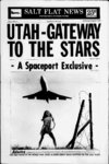
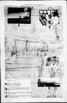
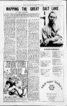
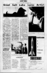
Show SALT FLAT NEWS, 6 FEBRUARY-MARC- H, 1971 TIU! Text and Photo by Joe Tordiff Dr. Deon C. Greer is 'an assistant ' professor of geography at Weber State College in Ogden. He studied on the undergraduate level at Brigham Young .University, Provo, and did his graduate work at the University of Indiana, Bloomington. He taught in the European division of the University of Maryland for five years. His professional interest lies primarily in the Soviet Union and eastern Europe. SFN: Dr. Greer, I understand that youve been working on a map of the Great Salt Lake and that your reason for doing it is that there was no map available. Is this correct? Dr. Greer: Yes, Ive written several articles on the lake and on Utahk economic development. I have been lecturing at various organizations in Ogden and have presented papers at professional meetings. In the process of trying' to give this material I looked around for a map you need a map of the Great Salt Lake if youre going to talk about it and oddly enough I couldnt find one. I looked hard. I asked the people who I thought would really know, and I found that there just was no map except a relatively specialized one of northern Utah which covered about one-fift- h of the lake. There were small-scal- e maps prepared from aerial survey but no large-scal- e map that I could find. I felt that this was a gap that needed to be filled. There was a need and the need developed into a map. SFN: How, exactly, do you go about producing a map? Dr. Greer: The first thing was to prepare a large, rather crude map composed from U.S. Geological Survey quadrangels. The quadrangle indicates an area of seven and a half, minutes of arc on the earths surface and is made by aerial survey. It is the basis from which all maps in the United States are made. I used about forty quadrangles as the basic building blocks for this first map. They were prepared from surveys made in 1965 and 1966. Perhaps this is why the' map wasnt made until now. It couldnt have been made to this scale and with this accuracy without them. My next step was to find a publisher. I wanted to have it published by the Association of American Geographers because it would then go into practically every library in the world. It SFN: Did you do any actual ground survey along with the. would be a feather in my cap to publish in their Annals and would bring Weber State some good notoriety. I wrote to them and found that they were interested. They invited me down to Los Angeles to show them what I wanted to do. Because of the interest people around the world show in the Great Salt Lake, they decided to include it in their series. I came back and started to work. The recent interest in the chemicals in the lake has caused the USGS to survey the west side of the lake for the. first time, the north arm and south end for the first time. They had never done any of it except here on the east side. There werent even finished quadrangles available, I had to work from proofs which I got from their headquarters in Menlo Park, California. The proofs covered an area about twice the size of this wall. I had them photographically reduced to the scale of my preliminary map. I then compiled all the other information I could get from every source available. I have a pilots license, so I was able to fly over the lake and take my own photos. SFN: What kind of equipment did you use was it an aerial other? Dr. Greer: No. It was all done aerially. You' see, there had been so much done since the USGS survey was made in 1966. Intermountain Chemical, all of these National Lead or exbeen built had ponds a to great degree. All of panded . ... this information had to be collected. Information on the brines, on the flow and fluctuation of the lake came from the Utah Geological Survey in Salt Lake City. SFN: After the information had been collected, then what? Dr. Greer: The next step was to draw the map. We dont have the facility to do it here at the college so I went to the Forest Service in Ogden, where they had the necessary materials. The preliminary map was done with pen and ink, this one had to be scribed on a plastic sheet. The overall size was reduced to 36 by 42 inches. Actually, there were a number of sheets because the map would be printed in several colors. I had to do a black-lin- e plate for all of the black lines on the map and a black letter plate for the black lettering. I did a brown-lin- e plate and a brown-lette- r plate for the contour lines and lettering. I did a blue-lin- e plate and a blue-lette- r to indicate water, plate streams and so forth. And then I had to do three other blue plates to indicate the contour of the lake at various levels. The lake only goes down thirty feet, so I made three depths, ten, twenty and thirty feet. These are called isobaths, indicating the depths in light blue, medium and dark blue. All of these plates had to be scribed on the plastic sheets with special instruments. The plastic has a coating much like the emulsion on photographic film which is scratched or cut away. SFN : That sounds like a great deal of work. Dr. Greer: I spent about a thousand hours of my own time, plus utilizing some student help. This was spread out over an eighteen-mont- h period. I spent two or three hundred dollars of my own money and the school has given me six hundred and fifty, which has just about been . camera? Dr. Greer: I used a Pentax a 35mm camera. My purpose was to update the survey of the USGS. I. would compare my pictures with the. map and make necessary changes. My photos of the Morton Salt Company salt ponds, showed them much larger. I went to Morton, told them what I was doing, and asked for a plat of their ponds. I then brought this to the scale of the map and incorporated it. I did the same with all the other e around the lake. spent. SFN : Will you copyright the map? MURDER SYNDICATE Again the heavy hand of fate and shame Reveals its bloody course of greedy crime. Once more our President lies cold in State To stall progress and change of time. We masses seem stuped as flocks at pasture Who bleet when hurt and flee when afraid. Content in the fence our captors constructed Seldom stick out our neck, preferring the shade. Yes, Presidents come and Presidents go, How long, how long will wrong prevail? In this land of the free and home of the brave But crime is a curse which Four murdered Presidents confirm our guilt As larTdoHhe gangster and home of the slave. We remains. And so long as we bolster its ugliness share-i- its pains. its guilt and suffer .Thou Shalt Not Kill, natures Free Enterprise, Tis a viscious giant Which rapes and grasps and weals. Stifling the cause of our Democracy God decrees. Yet our viscious circle prevails; Can a ship with its rudder twisted askew Attain to its course by lone , tattered sails? Somethings rotten in Dallas. (Free Enterprise) A. C. Gregerscn And blunting the soul of its shields. Dr. Greer: Unfortunately, I cant. The Association of Ameri- Would this ad make a good paster? If enough good folk say yes, b.lch printed upnHm.ter.ri k. fan if Village Brownstone. Jus, Call us at end 11 lij. HI,. em far The Cempeny i hnlfXt V.H.. Ud. can Geographers are. the people who will copyright It. I get nothing out of it except the recognition. It will cost the A AG about five thousand dollars to print it. They figure that they lose money on every map they publish. It is at the printers now and will come out in the March Annals as an insert. It .will go to ten thousand subscribers, every university in the world . . . every AAG member in the world, ,so it will have wide distribution. Anyone can buy it from the Annals for three dollars. SFN: Now that the map is about to be published, what will it be used for? Dr. Greer: It is really meant to show the economic use of the lake. It shows the chemical composition and location of each brine type in the lake. It shows fluctuation of the lake level, as well as precipitation, and explains where the water comes from. It shows current flow directions S. hf 9 Jr r Small enough to know you, Big enough to serve you. S & D LAUNDRA-MA- T announces NEW dry-cleani- ng PHONE facilities 665-232- 2 |