| OCR Text |
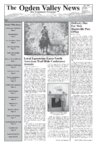
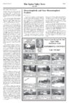
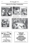
Show Page 6 The Ogden Valley News Volume I, Issue X July 1999 Forest Service Information Dear Forest User: The Ogden Ranger District of the Wasatch-Cache National Forest is proposing a watershed restoration project in the public grove area along the Avon-Liberty county road. A field trip is planned for Tuesday, July 13, 1999 to review the proposal. We will be meeting at the southern cattle guard on the Avon-Liberty county road near the forest boundary and the county line at 11:00 a.m. Enclosed is a scoping document describing the proposal. The field trip would be a good opportunity to review specific proposed actions and to make comments. You are invited to the field review as well as to return comments to us by August 1, 1999. Please review the enclosed document and call or send comments to Heidi George, Ogden Ranger District. Sincerely, RUTH M. MONAHAN District Ranger Physical Description of the Area: The public grove area falls under the Cache Management Area #11 (Wasatch-Cache Management Plan). This area is the watershed divide between two distinct watersheds: The Ogden River and the Little Bear River. The public grove area is accessible by the Avon-Liberty Divide County Road bounded to the north and south by moderate to steep slopes. The area contains fragile soils and vegetation that are susceptible to soil damage and erosion. The Great Western trail system, which runs from Canada to Mexico, follows the existing County Road and allows vehicle use on this portion of the trail. The road near the divide heads east to Fish, Wellsville, and Davenport Creek. The area is designated as closed to all motorized use, except on designated routes (FS road 092) off the main Liberty-Avon road (FS road 220) in the Travel Plan. However, significant illegal off- road use is occurring in the area. Many of the slopes are experiencing significant use and water shed disturbance. Its popularity and access to further remote, although closed, trails has made enforcement of the Travel Plan difficult. History of Land Use Off-road vehicle use has continued in non-designated areas and watershed degradation is ongoing. The location of a spring in a meadow at the base of a steep knoll creates a resource conflict where a sensitive wetland lies adjacent to an unauthorized hill climb. During the wet season, these soils are particularly sensitive to disturbance. Road closures during early spring and late fall on the main Avon-Liberty Divide County Road have assisted in protecting the road surface and minimizing impacts. However, vandalism to the gates and illegal motorized use has continued. Three miles of flat area are used for getting around the mud holes so that the road area is getting wider and wider as vehicles try to avoid the impassable portions of the actual designated route. Diamond Peak 745-0101 The V alle y’s Mountain Bik adquart er Valle alley’s Bikee He Headquart adquarter erss “For all of your knobby tire needs” ♦Trek Authorized Dealer ♦ Professional Repairs & Bicycling Accessories ♦ Our friendly staff can inform you on favorite trails in the area ou Have V isit or s, CCamps, amps, FFamily amily Do Y You Visit isitor ors, Reunions? HERE ARE SOME IDEAS! ♦ Trek Mtn. Bike Rentals - Full suspension & Hard Tails ♦ Sea Kayak Rentals ♦ Yamaha Watercraft Rentals 10 a.m. - 6 p.m. Tues. - Sat. Reservations for other days upon request Coupon $5.00 oofff Bik a Bikee Repair or Se Sea Kayak Rentals good thru July 1999 only History of Restoration Efforts A gating and closure agreement of the Avon-Liberty Divide County Road agreement was made between the Forest Service, Weber County, and Cache County in 1995. Two gates are on Cache County and one is on Weber County. Closure is after November until May, based on the weather and road conditions. Law enforcement has been problematic and not effective. The Weber County gate has been vandalized and there has been difficulty implementing closure because of adjoining private land access. Weber County is working toward improving gate enforcement. Some law enforcement efforts have not been upheld in court as the judges ruling reflected that our efforts were not being communicated effectively to the general public and therefore not taken seriously. In 1992 the area around the wetland, below the hill climb, was protected with wooden barriers and seeded. The barriers were ineffective in stopping the illegal use. In 1996 and 1997 the Forest Service worked with the State to get restoration ideas. A buck and pole fence to force people to stay out of closed areas was agreed upon. The buck and pole fence was installed and is still intact. However, the length of fence has proven to be too short, and people have gone around the ends of the fence. that addresses future management and further restoration needs will be approached within the next few years. This area includes the Public Grove Cattle Allotment which is on schedule for analysis and will be considered in the range allotment management plan. Expected results on the ground include: restoration of a disturbed wetland, extending the timing and duration of perennial stream flow, and subsequent incremental improvement of Bonneville Cutthroat habitat. Purpose and Need The purpose and need for the Public Grove Watershed Restoration project is to address ongoing challenges in implementing the current Travel Plan and meeting land management objectives of soil, range and watershed condition as directed in the Forest. Previous efforts to fully implement the Travel Plan and improve watershed conditions, have not been fully successful. Specific Proposed Actions: The following specific proposed actions are intended to address the identified management needs. Scoping Document • Public Grove Watershed Restoration Wasatch-Cache National Forest Ogden Ranger District Weber and Cache Counties July 1, 1999 The Ogden Ranger District has initiated an environmental review of proposed watershed improvements in the public grove area along the AvonLiberty Divide County Road. The proposal will implement existing Wasatch-Cache National Forest Plan direction, Clean Water Act objectives as described under Forest soil, range and watershed condition, Forest Travel Plan restrictions, and meet riparian management objectives as directed in the Wasatch-Cache National Forest Rangeland Health EIS (1996). In addition, Forest Service road (FS road) 26015 would be maintained up to a natural barrier location where it will be closed. Currently travel on this road is closed under the existing travel plan. However, vehicles have been going around the closed road up to an area approximately 400 feet beyond this point to a natural barrier. Therefore, enforcement could be more successful if closure is relocated to that natural barrier. A change to the Travel Plan would be necessary to recognize the existing use to this barrier. Current watershed conditions in the public grove area are in need of restoration. This upper watershed area has a high potential for recovery from a non-properly functioning condition to a properly functioning condition. Historical efforts to improve watershed conditions have not succeeded in watershed recovery. The scope of this proposed action is limited to minor watershed improvements to respond to immediate watershed restoration needs. It has also been identified that there is a need for a more comprehensive proposal for this area. This more comprehensive proposal • • • • • • • • • Rehabilitate existing disturbed closed roads, ghost roads and ORV hill climb areas by ripping and seeding to improve watershed function. Add barrier rock or buck and rail fencing at the mouth of these areas. Sites will be signed to explain restoration efforts. Enclose the South Fork of the Little Bear River riparian area and wetland to encourage aquatic regeneration. Enclosure would begin from the spring source and end at the intersection of the AvonLiberty Divide County Road and the north east forest boundary (see map). Partial fencing along the north side of the Avon-Liberty Divide County Road to enforce closures. Rest enclosure from grazing during rehabilitation to promote revegetation. Extensive buck and pole fencing along the south side of the road to prevent any access to the hill climb area. Replace existing gates with more damage resistant gates and locks. Maintain and spot gravel loop road or portions of loop road (FS road 220). Maintain and gravel FS road 26015 to a natural barrier and add barrier rock. Fill in mudhole with soil at “Mudder’s Hole” (east side of road at south end of loop). Improve existing signing efforts. Replace signs and maintain existing signs. Responsible Official The deciding official for this project is Ruth Monahan, Ogden District Ranger. Implementation Date We tend to implement this project summer and fall of 1999. Comments We welcome any comments, in person, by phone, or mail by August 1, 1999. Please direct your comments to Heidi George at (801) 625-5112. OGDEN RANGER DISTRICT 507 25TH STREET SUITE 103 OGDEN UTAH 84401 |