| OCR Text |
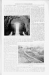
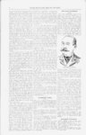
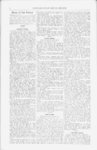
Show INTER-MOUNTAI- N MINING REVIEW. 5 through Nephi canyon to Nephi, it lower end here, constitutes an ideal turns north through Juab valley. This natural reservoir site. At the narrowest part of this gorge The Irrigation system just completed creek has a watershed of over 200 and near its head is located the dam. by the Mt. Nebo company south of square miles, most of it including Mt. Utah lake, while in no way connected Nebo and the high mountains sur- This is 210 feet long on top, 130 feet at with the mining Industry, presents rounding it. Near the north end of the bottom and 30 feet high. The width 110 feet, and at top 8 feet. some hydraulic engineering features of the valley the creek cuts through the at base is The body is of selected clay, thoroughly great interest, and methods and means low range of mountains on the west, rolled with a corrugated were adopted which may be advanta- which also forms the line between Juab sprinkled and iron roller in layers as built; the upgeously used in the impounding of wa- and Utah counties. Above this point stream slope is faced with loose rock ter and construction of ditches for mi in Juab valley the fall of the stream is and heavy boulders, laid by hand and fiilled with earth to a thickness of 3 feet; the downstream slope is composed entirely of heavy gravel and loose rock, the width of the layer varying from 12 feet at the foot to 3 feet at the top, and the stones are assorted and graduated in size so as to have the largest on the outside and the smallest inside next to the body of the dam. Before construction the foundation for the dam was stripped of the surface soil, and three trenches, one at each toe and one at the middle of the dam, and each 12 feet deep, were dug down to the bedrock and refilled with the best material obtainable, sprinkled and thoroughly tamped, to shut off any possible seepage of water under the dam. Where the dam Joined the solid rock ledges or abutments at the ends, these were trenched to form a perfect bond between the dam and the rock faces. At the west end of the dam Is located the outlet tunnel, for drawing off the water from the reservoir. This is cut through the solid rock ledge or abutment at the end of the dam, thus avoidVI EW OP OUTLET GATES, LOOKING FROM EOCK TUNNEL INTO RESERVOIR. ing any risk that might be incurred in the water through the body of passing ning purposes. These engineering fea- very slight, but through the mountains the dam itself. The tunnel is 140 feet tures are fully treated below, with in Currant creek canyon the fall is long, 6 feet high by 4 to 5 feet wide, some general data concerning the sys- quite heavy. This canyon extends but and a portion of It is located on a tem. Over $100,000 were expended in about three miles, opening out into the curve. the construction of the dam, reservoir and canal system, and in addition to this a large outlay was involved in the purchase of water rights, rights of way and private land. The Mt. Nebo company system conMT. NEBO IRRIGATION WORKS. sists essentially of a reservoir for impounding water with a dam forming the same, two canal lines located at a sufficiently high elevation to cover all the lands needed, and as fine a body of land as can be found within Utah, only awaiting water to render it highly valuable. This undertaking was first projected in 1S92 by the Mt. Nebo Reservoir and Canal company, and the preliminary surveys were made then, but it was not until early in 1895 that the present company was formed and construction begun. The Mt. Nebo reservoir lies in Juab county, Utah, taking its name from Mt. Nebo, one of the highest mountains in the State, and forming the summit of the Wasatch range, here close on the east. Tlie Juab valley is inclosed by the Wasatch on the east and another but much lower range on the west, and at the lowest point of this is the reservoir site. The valley is traversed from south to north by Currant creek. This creek has its source on the east side of Mt. Nebo, near the divide between Juab and San Pete counties, and after runnig southwest and wrest WOODEN PIPE LINE, FOUR FEET IN DIAMETER, CONVEYING WATER UP THE SIDE OF THE CANYON. Goshen and Kimball creek valleys, where are located the lands to be irrigated. The broad basin in Juab valley spoken of, together with the narrow outlet through the solid rock at its The most interesting feature of the with the gates tunnel is the gate-shaf- t, for regulating the flow of water. The gate-sha- ft is sunk from the top of the rocky ridge directly over the tunnel, and is 4x5 by 34 feet deep. At the bot- - |