| OCR Text |
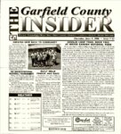
Show PANGUITCH • PANGUITCH LAKE • HATCH • BRYCE • TROPIC • ANTHMONY • HENRIEVILLE • CANNONVIIXE • ESCALANTE • BOULDER • DUCK CREEK INMATES GIVE BACK TO COMMUNITY Wednesday May 31, 2006 the inmates of the Garfield County Jail giving Panguitch High School new sod. From left to right School Board Member Mac Oetting, John Orton, School Board Member Jeannie Way land and inmates. 'Thanks to Kay Englestead, John Orton, Brandon Hatch, and Mac Oetting, this project finally got done." Says Jeannie Wayland who is funding the project PAT DIX INVITATIONAL BASEBALL TOURNAMENT QUILT WALK PARADE AND RACE Friday and Saturday, June 16th and 17th the Panguitch High Bobcats will host the 3rd Annual Pat Dbt Invitational Baseball Tournament. Involved will be 16 teams, 1A thru 3A, from all over Utah and Nevada. Play will begin at 8:00 am both days of the tournament with a full slate of games guaranteed to satisfy the appetite of the most rabid baseball fan. On Saturday, June lQth at 3:00 pnl a Quilt Walk Parade and Race will be held on Main Street (Center Street to Blue Pine Motel). As part of the parade, the Seven Quilt Walk Pioneers will be honored with a banner containing their name. We invite descendants of the seven men to join behind the banner of their descendant Other's may join the parade celebrating our Pioneer theme. We invite the businesses and citizens to wear their pioneer costume. Following the parade we will WEATHER Ihu > K«*D cooling isoL-t.Kd Storm; Jun 0 IftdT- Sal Jun ID Sim Jun 74OF 7-1V-W 30% 77°F 30% 30 V, il 84°F Your Plqr.tr From 84°F OS S5°F have a Quilt Walk Race. Any organization wanting to compete you are welcome. You will need seven participants. The quilts will be provided. Prize goes to the winners favorite chanty. Questions call: John and Pam Yardley @ 676-8023 Thursday, June 8, 2006 • Issue # 63 NAVAJO LOOP TRAIL ROCK FALL At BRYCE CANYON NATIONAL PARK On Tuesday/May 23,2006 at 5:00pm on the Wall Street section of the Navajo Loop Trail there was a significant rock fall. While there were people on the trail at this time, no one was injured. The rock debris covers an area roughly 60 feet long, 15 feet deep and 15 feet wide. There is approximately 400-500 tons of rock in this area. The rocks range in size, the largest being the dimensions of a midsized car. The trail will remain closed at this site to ensure visitor safety as we develop a plan to reopen the trail, complete environmental compliance, and obtain funding. It is projected that work to clear the rock fall debris will start in the spring of 2007. If deemed safe the park plans to open both sides of the trail up to the rock fall, so visitors will be able to view the rock fall and the large spruce tree in Wall Street. The rock fall was caused by the same processes, mainly erosion and weathering, which have shaped Bryce Canyon into what visitors see today. The primary weathering force at Bryce Canyon is frost wedging. Here we experience over 200 freeze/thaw cycles each year. Water or melting snow seep into the cracks of rocks during the'day and at night the water freezes. When water freezes it expands by almost 10%, bit by bit prying open cracks, making them ever wider in the same way a pothole forms in a paved road. In addition to frost wedging, rain also sculpts the landscape. Even the crystal clear air of Bryce Canyon creates slightly acidic rainwater. This weak carbonic acid can slowly dissolve limestone grain by grain, rain is also a source of erosion. In the summer, monsoon type rainstorms, travel through the Bryce Canyon region bringing short duration high intensity rain causing the relocation of rock and soil debris. All other trails in the park remain open at this time. Visitors are still able to complete a loop between Sunrise and Sunset Points by connecting the Two Bridges side of the Navajo Loop and Queens Garden. Routine maintenance will be preformed on other trails during the summer months. These trails will still be open, but there may be short delays to maintain the safety of the crew and visitors. Be prepared for hiking at Bryce Canyon The Rangers stress safety when talking with visitors: emphasizing the importance of wearing proper footwear and hiking on trails that are within their abilities. Walking sticks are recommended. Some of the trails are muddy and can be slippery. There are boot washing stations at the new Sunset Point restroom facility. People do not realize that Bryce Canyon is above 8,000 feet in elevation and arid. For these reasons visitors may want to dress in layers and certainly take plenty of water with them. Remember, erosion is constant so be aware of your surroundings. Bryce Canyon National Park is interested in providing you with a safe visit to your park and strives to make your experience here one of the best. Don V be too timid and squeamish about your actions. AH life is an experiment. The more experiments you make the better. Ralph Waldo Emerson BOXHOLDER 4^^ a Phone: ®*teft£ -sssa. PRESORT STANDARD PAID LOA, UTAH PERMIT No. 5 Murrr . u x PO BOX 472 snapshot@scinternet.net Loa, Utah 84747 THE GARFIELD COUNTY INSIDER is owned and operated by Snapshot Multimedia and distributed weekly to all of Garfield County . Its purpose is to inform residents about local issues and events. Thank you. |