| OCR Text |
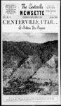
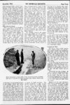
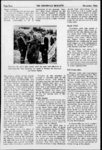
Show THE CENTERVILLE NEWSETTE Page Two .J Salt Lake City and Brigham City. Along this fertile belt of rich farm land Utah pioneers had built their homes at the mouths of canyons having permanent streams. On August 13, 1923 destructive floods swept down many of the canyons in this area, wreaking havoc and loss of life in the inundated areas at the canyon mouths. Damage to property and lo.cs of life was particularly heavy in the Centerville-Farmingto- n area. Here, 5 out of By A. Russell Croft and Leonard W. McDonald1 population Centerville, Utah 1940 census, 691 people; location, 11 miles north of Salt Lake City, y religion, predominantly Latter-da-exceSaint; leadership and vision, llent; cooperative community effort, superb; has a fine church building and beautiful public square; his- 7 canyons produced floods which, of according to geologists, exceeded tory, typical of the inmajority the 1850s in severity any which have ocUtah towns: Settled at the mouth of Centerville Canyon curred since the recession of an- where there was a supply of water for culinary and agricultural needs. Chief industries, general farming, fruit growing, plant nurseries, and living. That, briefly, is the background of this typical Utah town which decade, without during the past fanfare, has set a pattern for c- community action and vision which might well be emulated by the vast majority of towns ooperative in Utah. Its an old and familiar story to the residents of Centerville thats probably the reason for its nota having been told 5 before. Its success story about projects which the town and its residents pushed First, a through to completion. soil and unique watershed and water conservation program unlike anything in the western states, excepting California; second, the planning and drilling of aa town well and installation of pump which tided the town over a severe drought and serves yet as insurance against a possible water shortage; third, the renovation and beautification of the town cemetery from a patch of weeds to a show spot; fourth, the sprucing up and de- velopment of the town square; and fifth, the acquisition of a city paint gun which virtually repainted the town and is still being used by its citizens. All this and no increase in the town tax! Some of these items are major projects and deserve major attention, and some of them are minor activities. But it takes both to show what this town did and what others can do. To begin with, lets go back to August 14, 1923. That day will live long in the memory of residents western base of along the the Wasatch Mountains between 50-m- ile Conservationist, Intermountain Forest and Range Experiment Station; and Editor. The Utah Farmer, respectively cient Lake Bonneville, many thousands of years ago. Five people lost their lives at a canyon campground which had been used with perfect safety since settlement in 1848. Again on July 10, 1930, similar floods came down 6 of the 7 canyons. Resultant damages included the demolition of several homes, the surfacing of hundreds of acres of garden and farm lands with mud and rocks, including boulders weighing individually up to 200 tons; and the blocking of the State highways and an electric railroad. Flood damage in the Centerville-Farmingto- n area was appraised at $1,000,000 for the floods of 1923 and 1930. Conspicuous in its absence from the flooded areas is the seventh canyon area, Centerville. There was a reason. Hy iyzd tne Centerville town boaru, unuer tne leauersnip ox Mayor u. xi. brrnin, pioneer nurs- eryman, naa tnrougn purcnase and contract gained control ox tne entile mountain watersnea east of Centerville xrom wmcn Centerville creex drams and upon wmcn the town was completely dependent tor its household and much of its irrigation water. The lesson of 1923 had been well learned; flood control through proper watershed management was one of the chief objectives in acquiring ownership of this land. An investigation conducted in 1930 by the Intermountain Forest and Range Experiment Station, in cooperation with the geology department of the Utah State Agricultural College and the Utah Agricultural Experiment Station, fixed the cause for the floods in the other canyons upon destruction of the native vegetation on their headlands by fire and excessively heavy grazing. November, 1944 Planning Prevents Floods Centerville, through planned protection of its watershed, permitting conservative grazing only, has escaped the devasting floods which ravaged neighboring communities. But more than that and this is a point which in the long run may be far more important than warding off a flood Centerville in protecting its watershed has insured its future water supply. Floods from watersheds, which for centuries have not produced such, become prophetic of the approaching end of an irrigation era, for streamflow out of control as floods are may destroy much of the wealth that a more regulated flow produces. The value of water to a commurt such as we live nity in a in, becomes in effect the value of the community itself. This importance of water grows out of the fact that a very high proportion of all our developments in homes, industry, and agricultural improvements depend upon mountain water. g lands in Centerville Canyon amount to about 1,000 acres which lie between 6,000 and 9,000 feet elevation where deep snow accumulates and annual precipitation is more than 40 inches, compared to 17 inches in the arid valley. Although the people of Centerville buy and sell shares in the canyon water among themselves at prices which establish the streams value at $50,000, they would not sell it for $250,000, for, as Henry Cleveland said, All we have depends on it and we cannot replace it. And all this comes from 1 square miles of high mountain brush and timber land sort of a humid island that projects upward high enough to capture some of the moisture that is passing in the air overhead. Another' way to look at the value of watersheds, although a negative one, is to consider the damage caused by floods as a result of mismanagement. For example, the total flood damage in the vicinity of Parrish Creek, directly north of Centerville drainage, was $158,000 from a watershed of 1,373 acres. Prorated to the entire watershed this represents damage of $115 per acre. If the total damage from the Parrish Creek flood is prorated to the land from which approximately 80 percent of the flood water actually came, which is about 10 percent of the total area, the damage per acre is about $1,173. This all goes to show that when we build a town or city at the mouth of a semi-dese- Water-yieldin- ex-May- or |