| OCR Text |
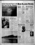
Show 1 ISLAND Measuring the settlement of a test fill to determine the weightcarrying capacity of the Great Salt Lakes bed is H. J. Willard, construction division engineer, Salt Lake division of the Southern Pacific. On the mountain behind him is plainly visible the beach of ancient Lake Bonneville, of which the lake is only a small remnant. MAN-MAD- E Multi-Millio- n Dollar Project To Take Years (Continued from Page One) ' northerly face Saline fill. -A second step, authorized last month, will involve the placing of another 100,000 cubic yards, starting at the Saline end of the new alignment and proceeding westerly, to a point where future dredging operations will be required. Eventually the fill would extend some 13 miles, connecting the ends of existing shallower the fills, and would s trestle. The fill would be created, according to present tentative plans, by barging most of the rock and gravel, out , from. , a quarry and dumping it along the line of the timber islands millions of tons of it until the fill rises and splits the surface of the lake, it would then be widened and strengthened with huge rocks to protect the fill against the fury, of the lake'3 storms. Heavy Water Storms on the Great Sait Lake generate waves that pound more by-pas- s world-famou- . iheavily than ocean waves. Ev- ery five pounds of water in this lake is loaded with an additional pound of salt, about seven times as much salt as in ocean water. The salt leaves a white rim on the timbers sometimes in thick .coatings that drip like snowy stalactites, or mushroom encrustations that may double the diameter of a piling where it enters the wafer. If water from this lake splashes on hands or face or clothing, and dries, a white crust will be left to brush off. The water is so much denser than a human body that a person cannot sink in it The water weighs 78 lbs. per cubic foot compared to normal weight of 62 lbs. for fresh water. It is so briny that no fish or other animal can exist in it, except one species of very small shrimp. Of all the obstacles encountered in, constructing the original transcontinental . railroad, only the Great Salt Lake sucpioneer cessfully defied the Sierra builders. The mile-higNevada Mountains were conand quered despite granite snow. The dry, hot and desolate desert was spanned in record time. But when the Great Salt Lake blocked the way, our tracklayers detoured north of the lake, twisting and raising their track through the hills to meet the Union Pacific tracklayers at a place called Promontory (not to be confused with the present 'Promontory Point). There they drove a gold spike, 0X- TEST . LOCATION From this test island, standing out of the Great Salt Lake, technicians are probing the secrets of the lake. The pipes help them measure the settlement of ag unseen fill they have poured under the water, and also tell them how much water is mud by pressure of the fill. being forced out of the lake-botto- m . , - i WEDNESDAY - THURSDAY SPECIALS! APPLE TURNOVER. -- - ij BAKERY DELICACIES I . . 80 FRIDAY - SATURDAY SPECIALS! , r Assorted SWEET ROLLS, (loi.39c Fresh Short Shank Picnics !S&G SALT CRYSTALS Salt stalactites decorate timbers of the Great Salt Lake trestle after they have been washed by high waves in a storm. The saltiness of the lake water is about seven times that of the ocean. from the mountains to purify pending on the level of the lake ed through them. The concenthe land also carried with them which rises and falls with the trated salt water ' actually some soft clay that settled on seasons and with wet and dTy 'pickled the piling to preserve the bottom of the lake and Com- cycles of years). In this dis- them virtually forever. bined with skeletons of the tance about four miles of track With the .coming of, heavier shrimp to a depth ranging from' Hes on Promontory Peninsula. trains the trestle has been 20 to 60 feet, created the un- The rest is built on fills or tres- strengthened with additional stable foundation that is troub- tles, the original trestlework to- bracing. It is stronger than tobuild a level trestle or fill ling engineers and scientists taling 22.94 miles. Part of the when 'it was built. across the lake although the day, but which we now know original trestle was filled, unExploratory - work has been til today the length 'supported going first proposal for such a proj- can be stabilized. on for months to deteron pjl'ing is 11.87 miles. Sixteen ect was made in 1868. mine how to build a fill that is to squeeze the day miles Proposal have been double Was Much Bigger well be classed yvith the successive wide loadings of and in 1945 fcentralized tracked, Traffic may The lake is about 4 200 feet by sand and gravel until it be- Control was installed for the wonders of the world. On such above ocean level. Untold ages comes stiff a fill trains would be able to enough to support a ago water was 1,000 ft. higher, fill. The piezometer tubes show entire distance, t with remote roll across the Great Salt Lake of control switches track and at normal speeds instead of uncovering what is now Salt Lake that much of the water can thus City to a depth of some 900 feet. be removed, firming the clay signals at the fingertips of' the der speed regulations as on the dispatcher seated at his desk trestle More trains will be able History of this earlier inland considerably. in Ogden. t sea can still be read plainly in Crust Is Hard j ' to move, to serve The Golden , horizontal lines Under the When the cut-of- f across the Empire, spectacular fastest growing part Is ancient the clay cut which the andient waters crust left by Lake Bonne- lake was built, our builders ex- of the nation. salt into the mountains that rise ville. This crust is rocksalt, so pected that the trestles would abruptly thousands of feet above hard that the engineers have to give more trouble than the fills. , The elements carbon, copper, the present lake. There on those use diamond drills tb cut it and The opposite was found to be gold, iron, lead, mercury, silver, true. The fills settled for years, sulfur, tin and zinc, were dishorizontal beaches the waves of up cores for study. They the ancient sea lapped the bring before the birth of have also pushed the'ir drills and were badly battered by the covered shore. It was then 346 miles down heavy waves, needing continual Christ. and crust the salt through to maintain them long and 145 miles wide. To have brought up cores of firm- building-uwalk around it iwas a journey of er , are was deposited un- and solidify them as they that clay 3 Box Elder NEWS The trestles, ' on the 2,250 miles. today. on to an it unknown der depth The marks of 'Yiie'' ancient other hand, were hardly affect Brigham City, Utah floor of Lake Bonneville. the ed by the waves, which wash Wednesday, December 28, 195S beaches were first described by Trestle Since 1904 Captain Bonneville in 1831. In The famous trestle which the Ms honor the ancient sea was proposed fill may replace or named Lake Bonneville. was constructed as Lake Bonneville was swollen supplement, of the 103 mile Lucin cutpart by the melting Ice Age until it off. It was opened March 8, overflowed to the north, cutting and thereby eliminated the the canyon of the Snake river 1904, climb around the north end of and escaping to the Pacific the with its many curves Ocean via what we now call the that lake, added up to the equivalent Columbia. The rush of water of 11 complete Circles. The preseroded the land to create what ent lake crossing is nearly a Is now known as Red Rock Pass, line and almost until erosion was stopped by straightlevel. The distance perbeharder rock, and the lake once fectly tween of the lake ranges without betweenshores more was Imprisoned 30 and 32 miles (de an outlet. Through drier ages the lake evaporated and shrank, 'leaving a whole series of beach markings on the mountains, until the water evaporated enKotex Offers You Miracle Stretch tirely, leaving only salt beds The answers to everyday that became forbidding deserts. insurance problems The Great Salt Lake we know By Dee Johnson on formed be to today began one of these salt beds about 23,000 years ago from the run60 gauge 15 denier. Choice of Colors. Reg. $1.95 value off of the Jordan, Weber and Bear rivers. Complete Details in Kotex Packages Salt Washed Out In flowing across the higher lands toward the lake these rivers and the rains washed the QUESTION: - I heard about east of the Great Salt Lake, some people- who were paid sloping down from the base of by their insurance. Company the towering Wasatch Mounfor water damages to their tains. On those fertile lands the walls and ceilings. This was arMormons settled when they supposed to be under Extendrived in 1847 under Brigham ed Coverage. Is that possible? Others, in creaking, Young. ANSWER: If the house was wagons, moved on first so damaged by wind that toward California, some north water could enter, Extended around the lake on the route coverage would apply. the S. P. railroad later followed, some south across the poisonous Your choice of pink, If youll address your own insalt deserts. The Mormons stay-- i surance to this ofquestions yellow and white. ed. It was they who named the fice, well try to give you the Jordan river, connecting sweet correct answers and there will Utah Lake to the south with be no charge or obligation of 200's 400's the dead sea of the Great Salt any kind. Lake, like the Jordan river con-nects the Sea of Galilee and H. DEE JOHNSON the Dead Sea off the old world. " 134 So. Main Phone 19 Clay Carried Down The waters that flowed down linking the first rails across the nation. The track rose to an elevation 1,515 feet higher than the surface of the lake in. order to get through the hills; but this had to be done, because the engineers of that era were not equipped to iMay 10, 1869, Chuck Cul -- -- U. S. Choice 3?G msG Prime U.S. Choice p Tender Aged Sunkist Navel Thowimfam)! $100pr. BEVERAGES QOMT2for35 KLEENEX : i I SUNNYDALE CLOSEOUT 1 LB. . . sun-fade- 1 3 f 470 2 ,or 530 r ft 1 |