| OCR Text |
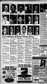
Show ' 1 V - , yv s Pink Ladta at American Foik Hospital join Cathy $trt, AFH NtoKintor Auxiliary PtMkiwit, and Klth Atoxandexr, AFH Adminlstfator, as they cut th ribbon tor the new community walking path at th hospital Hospital volunteers dedicate walking path A new community walking path at American Fork Hospital waa officially opened to the public. The path is com-plimenta com-plimenta of the AFH Volunteer Auxiliary that donated $20,000 to pay for the project. The paved path ia about one mile in length and circles the entire hospital property All members of the community are welcome to run, bike, jog, walk or stroll on the new path. Hospital administrator Keith Alexander states that the path is not the only significant signif-icant contribution the volun-teers volun-teers have made to the community com-munity thia year, They also donated $16,000 in equipment to assist a new rape examina-tion examina-tion protocol being implemented implement-ed in the county. He said they also donated $30,000 to help build the Family Guest House to be located in Provo, The Family Guest House will be an inexpensive place to stay for patients and family members who have traveled long distances to receive medical med-ical care in Utah County, Many of our volunteers have lived in American Fork for most of their life and feel a deep sense of pride and commitment com-mitment to the community. We are always anxious to get involved with projects that impact the quality of life in thia community said Carol Ann Durfey, director of Volunteer Services, Durfey said right now the hospital needs more volunteers volun-teers who typically work a four-hour shift every week, "The demand for volunteers is increasing, and we offer a variety of service opportunities. opportuni-ties. Our volunteers enjoy helping other people and we try hard to find something that suits each individual," Durfey said. For more information, or to volunteer, call 763-3506. Asthmaallergy class offered Do you suffer from asthma or allergies? A class to help you live with them will be held on Wednesday, June 10, at 7 p.m. in the Pleasant Grove Senior Citisen Center. 30 E. Center Street. The class ia free to the pub-lie pub-lie and lasts about one hour. Sponsored by Smith Rexall Drug, the class will discuss how to get the most out of your asthma or allergy medications, how to minimise aide effects, etc. They will discuaa some useful use-ful techniques that can be used to help prevent and manage asthma and seasonal allergies. Babysitting class to bo given at Am. Fork Hospital Babysitting classes are being offered throughout the summer at American Fork Hospital for children ages nine to 14-years-old. The classes are designed to provide an introduction to safe and fun babysitting with instruction on safety, first aid, CPR, infant care and babysitting kit ideas. Classes are scheduled for Wednesday, June 10 and 15, in the hospital's Education Center, The time is from 9:3C a.m, to noon both days. Anyone interested in attending should register by calling Julie at 756-5854. The $3 fee can be paid at the hospital's cashier's office prior to the first class, Citizen fi99 Press Review - June 10, 1998 -- Pago 17 Philanthropist highlights cancer survivor confab Town of Eagle Mountain gives notice of intention PUBLIC NOTICE IS HEREBY GIVEN that on the 9h day o June. 1998, the Town ol Eagle Mountain, Utah County, Utah (the Town"), adopted a resolution resolu-tion declaring its intention to create a special improvement improve-ment district to be known as Eagle Mountain, Utah Special Improvement District No, 98-1 (the "District"), It is the intention of the Town Council to make the improvements described herein within the District and to levy special assessments as provided in Title 17A, Chapter 3. Part 3, Utah Code Annotated 1953. as amended, on the real estate lying within the District tor the benefit ol which such assessments are to be expanded in the making pi such improvements. DESCRIPTION OF DISTRICT DIS-TRICT The boundaries of the proposed Distrjct shall coincide coin-cide with the legal description descrip-tion set kxth m Exhibit K all being located within the town limits ol Eagle Mountain, Utah, INTENDED IMPROVEMENTS IMPROVE-MENTS The improvements will consist of the construction and paving of approximately tour miles of asphalt road, the construction of a concrete con-crete curb planter median in the cent er of said road, the installation of sewer, water, telecommunications, elects ; cat and gas improvement; within the road right of way, the construction of landscaping land-scaping and park improvements improve-ments and the acquisition of water rights (collectively, the "Improvements'). Said Improvements will begin at the intersection of Stale Highway 73, proceed south to the intersection of the Lehi Fairfield Road, then both east and west to the boundary of the District The roadway will be known a the Ranches Parkway, The proposed location of said Improvements is shown on Exhibit ' B. attached hereto and incorporated by refer ence. - ESTIMATED COST OF IMPROVEMENTS The total cost of Improvements in the District as estimated by the Engineer is $9,740,000. of which the Town will pay $$0, leaving a remainder of $9,740,000 which shal be paid by t special assessment assess-ment to be levied against the property abutting upon the streets to be improved or upon property which may be affected or specialty benefitted bene-fitted by such Improvements. The Town Council has determined deter-mined that only those parcels within the boundaries bound-aries of the proposed District, the owners of which have a present intent to develop said parcels, shall be benefitted by the proposed pro-posed Improvements as indicated on the map attached hereto as Exhibit B. The property owners'portion of the total estimated cost of the Improvements may be financed during the construction con-struction period by the use of interim warrants, in which case the interest on said warrants wit) be assessed to the property owners. In lieu of utilizing a guaranty fund, the Town intends to create a special reserve fund to secure payment of the special spe-cial assessment bonds (the "Bonds) The town anticipates antici-pates issuing to finance the proposed Improvements, The reserve fund will be initially ini-tially funded with proceeds of the Bonds an amount equal to approximately $1,125,000, TheTown anticipates antic-ipates applying moneys remaining in the reserve fund to the final payment on the Bonds which, in turn, would offset the final assessment payments to be made by the owners of property prop-erty benefitted by such . Improvements, alt of which will be further described in the assessment ordinance to be adopted by the Town, In addition, the estimated costs of assessment include estimated overhead costs which the Town projects to incur in the creation and administration of the District. The estimated cost to be assessed against the properties prop-erties within the District and the method of assessment shall be as follows; Improvements Roads, sewer, water, gas, electric, telecommunications, telecommuni-cations, landscaping, parks and water right acquisition, Estimated Assessment $7,500, Method of Assessment Per Acre (' For the purpose of determining the most equitable equi-table assessment for improved properties, the Town reserves the right to make adjustments to assessments by acre by taking tak-ing into account the number of equivalent residential units to be constructed on each improved acre of prop- OF ASSESSMENTS K is the intention of the Town Council to levy assessments as provided by . the laws of Utah on all parcels and lots of real property prop-erty to be benefitted by the proposed Improvements within the District, The purpose pur-pose of the assessment and levy is to pay those costs of the Improvements which the Town wiH not assume and pay. The method of assessment assess-ment shall be by acre as set forth herein, The assessments may be paid by property owners in not more than ten (10) annual installments with interest on the unpaid balance bal-ance at a rate or rates fixed by the Town Council, or the whole or any part of the assessment may be paid without interest within fifteen (15) days alter the ordinance levying the assessment becomes effective. The assessments shall be levied according to the benefits to be derived by each property within the District. Other payment pay-ment provisions and enforcement remedies shall be In accordance with Title 17A. Chapter 3, Part 3, Utah Code Annotated 1953, as amended. A map of the proposed District, copies of plans, profiles pro-files and specifications of the proposed Improvements and other related information informa-tion are on Hie in the office of the Engineer who wiH make such information available to all interested persons. TIME FOR FILING PROTESTS Any person who is the owner of record of property to be assessed in the District described in this Notice of Intention shall have the right to tile in writing a protest against the creation of the District or to make any other objections relating thereto. Protests shall describe o otherwise identity the property prop-erty owned of record by the person or persons making the protest and shall indicate the total acreage represented represent-ed by said protest. Protests shall be filed with the Town Clerk ol Eagle Mountain, Utah, on or before 5:00 p.m. on the 14th day of July. 1998. Thereafter at7p.m. on the 14th day of July. 1998, the Town Council will meet in public meeting at the oflices of the Town Council at 4114 North 1680 East, Eagle Mountain, Utah to consider ail protests so filed and hear all objections relating to the proposed District. After such consideration and determination, the Town Council shall adopt a resolution resolu-tion either abandoning or creating the District either as described in this Notice ol Intention or with deletions and changes made as authorized by law; but the Town Council shall abandon the District and not create the same if the necessary number ol protests as provided pro-vided herein have been filed on or before the time specified speci-fied in this Notice of Intention for the filing of protests after eliminating from such filed protests: (I) protests relating to property or relating to a type of Improvement which has been deleted from the District and (ii) protests which have been withdrawn in writing prior to the conclusion conclu-sion of tne hearing. The necessary nec-essary number of protests shall mean protests representing repre-senting one-half of the acreage to be assessed. BY ORDER OF THE TOWN COUNCIL OF EAGLE MOUNTAIN, UTAH, s Janet Valentine Town Clerk EXHIBIT A Eagle Mountain - 1998 Special Improvement District Legal Description (total parcel): Beginning at the Northwest corner of Section 30, Township 5 South, Range 1 West, Salt Lake Base and Meridian; thence South 69 deg. 43 21" East along section line 1135 80 feet to the NE corner of Government Lot 1, a closing corner of Section 30, which point is also on the Easterly boundary of Fort Critenden Military Reservation; thence North 34 deg. 1608" East along said easterly boundary bound-ary 74.04 feet to the SW -Comer of Government lot 8. a closing corner of Section j 'j iiiifi? . -1 ii - " t 19; thence along said Fort Critenden boundary line as follows: North 35 deg. 40'00 East 535.26 feet and North 08 deg. 3000: West 853.01 feet to the NW- corner of Government Lot 8 of Section 19; thence North 88 deg. 1910' East 1135.48 feet to the NE Corner of said Government Lot 8; thence South 00 deg. 3V41' West along quarter section line 1279.11 feet to the North quarter corner of Section 30; thence South 89 deg. 18'39" East along section line 275983 feet to the Southwest corner of Section 20; thence North 00 deg. 1858 West along section line 2654.13 feet to the West quarter corner of Section 20; thence North 00 deg. 54't3 West along section line 1246645 feet to the southerly boundary of Cedar Pass Ranch Subdivision, Plat "J as recorded in the Office of the Utah County Recorder; thence the following follow-ing two courses and distances dis-tances along said Cedar Pass Subdivision, Plats "J and "D; North 89 deg. 05'47 East 113169 feel, and North 00 deg. 14'17 East 2395.7$ feet to the southerly right-of-way Ine of State Road 68; thence the following three courses and distances along said right-of-way line; North 89 deg. 14 024 East 309 94 feel, along the arc of a 5804.70 foot radius curve to the left for 1114.39 feet (chord bears North 83 deg. 44'02' East for 1112.68 feet), and North 78 deg. 14W East 2847.10 feet to section line; thence South 00 deg. 15'56": West along section line 1978 87 feet to the Northeast corner of Section 20; thence South 00 deg. 12'55 West along section line 2672.98 feet to the East quarter corner of Section 20; thence North 89 deg. 17 20 West along quarter section line 2657.50 feet to the Center quarter corner of Section 20; thence South 00 deg. 10'38" East along quarter quar-ter section tne 2665.33 feet to the North quarter corner of Section 29; thence South 89 deg. 0212' East along section line 1753.67 feel; thence the following twenty one courses and distances along the center of a wash; South 24 deg. 56 36 East 1.83 feet, South 27 deg. 2012 East 47.37 feel South 57 deg. 17'38 East 197.83 feet. South 08 deg. 1330" East 20540 feet, South 67 deg. 15'52 East 197.12 feet, North 56 deg. 02(26 East 94.61 feet, South 08 deg. 08'50 West 127.18 feet, South 50 deg. 12'10" East 48.04 feel North 54 deg. 39 22 East 113.62 feet, North 84 deg. 2844 East 9165 feet, South 61 deg. 28"58 East 66.30 feet, thence South 14 deg. 2V48" East 10876 feet, North 83 deg. 4059 East 142.28 feet, South 01 deg. 24 52" East 106 51 feel South 36 deg. 3717 East 218.46 feet, South 57 deg. 34'13 East 67.83 feet, South 33 deg. 2306" East 136.30 feet. South 56 deg. 3V12 East 155.18 feet, North 88 deg. 54'29 East 166.94 feet, South 33 deg. 10'35 West 40.34 feet and South 03 deg. 43'36" West 21505 feet: thence North 89 deg. l8'58"West atong 116 line 562 0$ feet to section line; thence South 00 deg. 37 28 West along section line 132195 feet to the East quarter corner ol Section 29; thence North 89 deg. 22'40" West along quarter section line 1327.62 feet; thence South 00 deg. 47'19" West along the west line of the West half of the NE quarter of the SE quarter of Section 29, 1322.55 feet; thence South 89 deg. 23'OQ" East along the South line of the NE quarter of the SE quarter of Section 29, 1331.55 feet to section line; thence South 00 deg. 37'04" West along section line 1322.37 feet to the Southeast comer of Section 29; thence North 89 deg. 23'20" West along section sec-tion line 1335.51 feet; thence South 01 deg. 06'47 West 668 63 feet; thence West 974.48 feet; thence North 08 deg. 19'32East 18824 feet; thence North 21 deg. 2013" West 307.90 feet; thence North 75 cleg. 37'07 West 360.84 feet; thence North 50 deg. 3336 West 359 75 feet; thence North 87 deg. 55 48 West 372.18 feet; thence North 68 deg. 11'55 West 217.19 feet; thence North 49 deg. 57 01" West-403.93 West-403.93 feet; thence North 27 deg. 19'57 West 448.95 feet; thence North 01 deg. 06'45 East 461.65 feet; thence North 43 deg. 40'04 East 136.29 feet: thence North 59 deg. 44'37 West 62.25 feel; thence South 37 deg. 46'33 West 453 55 feet; thence South 70 deg. 5337 West 724.58 feet; thence South 15 deg. 0819" West 888.60 feet to section line; thence South 89 deg. 5915 West along section line 68.85 feet to the SE corner cor-ner of Section 30; thence North 89 deg. 19 31 "West along section line 2657.40 feet to the South quarter corner cor-ner of Section 30; thence . South 89 deg. 57'05" West along section line 1473.81 feet to the SW corner of Government Lot 8, a closing corner of Section 30, said point is also on the easterly boundary of Fort Critenden Military Reservation; thence South 21 deg. 53'28" West along said easterly boundary bound-ary 42.70 feet to the SE corner cor-ner of Government Lot 4, a closing corner of Section 30; thence North 89 deg. 57'33" West along section line 1063 40 feet to the SE corner cor-ner of Section 25, Township 5 South, Range 2 West, Salt Lake Base and Meridian; thence North 89 deg. 36 51" West along section line 2673 83 feet to the South quarter corner of Section 25; thence North 00 deg. 50'24" East along quarter section line 2709.61 feet to the Center quarter corner of Section 25; thence South 89 deg. 31 '55" East along quarter quar-ter section line 1296.93 feet to the SW Corner of the East half of the NE quarter of Section 25; thence North 01 deg. 38'58" East along the west line of the East hall of the NE quarter of Section 25, 2604.26 feet to the NW corner of the East half of the NE quarter of Section 25; thence South 89 deg. 1507" East along section line 1333 69 feet to the point of beginning. Published in the Lehi Free Press June 10, 17 and 24 and July 1,1998. There are two classes of heroes, Jon M. Huntsman, Jr., president of Huntsman Cancer Foundation, said June 6, speaking speak-ing at the 1HC Cancer Survivors Day "Celebration of Life held at Mountain View High School, Huntsman said as a young man his heroes were sports figures, fig-ures, but today his heroes are the men and women who toil in laboratories, dedicating their lives to research to make things better for those who are suffering suffer-ing as well as the people who display courage in overcoming the odds of cancer. "Surviving is about having a 'can do attitude, Huntsman said, "overcoming adversity, about overcoming the odds. We celebrate life. Our challenge is to celebrate life to its fullness; celebrate life each day; celebrate with those closest to you. Tell them that you love them - those words we don't say enough." "Sometimes we forget how unique we are, that America was built with a 'can do' attitude. atti-tude. Never let this attitude go.lt is what makes us unique. Hold on to it Huntsman told the group that in the past wour enemies were the Germany, the Soviet Union and others. "Today 1 cant think of a better Public Enemy No. 1 then cancer. Wouldn't it be wonderful if we could marshal our forces and fight thi w ar on cancer just like we fought those wars. This is a war we have not won, but it is a war we can win. Yet, cancer research continues with insufficient funding." Despite the fact that the last six United States presidents have declared war on cancer, billions are still spent on defense, but only $12 million on cancer research. Only one-tenth of one percent per-cent of the total federal budget is used for cancer research although cancer claims more people each year than were lost in the major wars. "We can put a man on the moon - yet cancer remains a mystery. We must do better, We can do better. Peoples lifes are at stake." Huntsman said there has been more advances in cancer cures in the last six months than in the last 80 years but "I dont think anyone in the cancer can-cer field will say we have done all we can He told of Thanksgiving 1991 when his father told the family that he had been diagnosed with prostate cancer. "He survived sur-vived and now is a thriving, great example of someone who has survived." "Cancer is a terrible disease. It ravishes people. It ravishes families," Huntsman, who is president of the Huntsman Cancer Foundation, said his family has dedicated $150 million to help find the cure for cancer, feeling the best thing they can do as a "corporation is to leave the world a little better, "Our first goal is nothing short of finding the cure for cancer can-cer - and we are dumb enough to think it can be done.' The second goal is to provide care that is second to none in fighting cancer. He said cancer research has been underway the past two years at the Univesity of Utah and the Huntsman Cancer Institute, located behind the University of Utah Hospital, will be dedicated in March 1999, Janet Lee, widow of Rex Lee, introduced Huntsman, telling of some of his many accomplishment. accomplish-ment. "Celebration of Life activities activi-ties included booths set up to cover all aspects of the battle against cancer, free refreshments, refresh-ments, door prizes and a live auction PAF users group to meet Sat., June 13 in Provo The next regular second-Saturday-of-the-month meet-.., ing of the Utah Valley PAF (Personal Ancestral File) Users Group will be Saturday, June 13, from 9 a.m. until noon in the "Red LDS Chapel at 4000 North Timpview Drive (650 fcast),tn Provo. The main presentation will be a demonstration and comments com-ments about Legacy by Jay Markham, President of the Users Group. Legacy is a new genealogy computer program with several new features, After the main presentation various classes will be offered at different levels of computing and genealogy with something for everyone from bare beginner begin-ner to advanced user. All meetings of the Users Group are open to the public whether members of the Group or not. The Group has a goal of helping people with their family fami-ly history and there are usually 125-150 attendees at the monthly meetings on the second sec-ond Saturdays- For more information about the Utah Valley PAF Users Group and its meetings, and also links to much additional genealogy information, see their home page on the Internet at http:www.geneal-ogy.org-uvpafug. For telephone tele-phone information about the meetings or the Group, call the BYU Family History Library (Diane Parkinson, Family History Librarian) at 378-6200. Eagle Mountain may change development code The Town of Eagle Mountain, Utah, hereby gives notice that the Town Council will hold a public hearing on June 23, 1998, at 7 p.m. at the Eagle Mountain Town Office located at the Eagle Mountain Fire Station, 4114 N. 1680 East (Just off Eagle Mountain Blvd.-), Eagle Mountain, Utah. The purpose of this meeting is to receive comments com-ments concerning and take action on various amendments amend-ments to the Development Code for the Town of Eagle Mountain which include Mobile Home Guidelines, Definitions, Alleys and corrections cor-rections or amendments to Eagle Mountain various chapters of the Development Code. The public is invited to attend the hearing. Copies of the Amendment are available avail-able for review at the Eagle Mountain Town Office at 130 W. Main, Suite H, Lehi, Utah, until May 28, 1998. On June 1,1998, copies will be available avail-able for review at the new Town Office at the Eagle Mountain Fire Station. 4114 N. 1680 East, Eagle. Mountain, Utah, Monday through Friday from 8 am to 5 p.m. Janet Valentine Town Clerk Published in the Lehi Free Press June 3 and 10, 1998. Saratoga Springs considers setbacks On June 11, 1998, at 6:30 p.m., the Board of Adjustments for Saratoga Springs will hold a public hearing at 6394 N. 10800 West, Saratoga Springs, Utah, for the purpose of nearmg a request tor a vari ance from the setback requirements on lots 315 and 317 developed by Kaufman and Broad. All interested persons shall be given an opportunity opportuni-ty to be heard. eatea tnis zsm aay ot May, 1998. Timothy L.Taylor . Clerk Published In the Lehi Free Press June 3 and 10, 1998. Lehi City Council lists agenda items Notice is hereby given thai Lehi City Council will conduct a joint Special Session with the Lehi City Redevelopment Agency on Tuesday, June 16, 1998, at 7 p.m. in the Lehi City Council Chambers located at 153 fi 100 East, Lehi, Utah. The agenda shall be as follows: Public hearing 1. Lehi City Redevelopment Agency a. Approval ol Fiscal Year 1998-99 budget. 2. Lehi City Fiscal Year Budget a. Approval of Fiscal Year 1998-99 Budget. 3. Pascal Maria -Request for recommendation recommenda-tion of Zoning District and Zoning District Map amendment amend-ment on approximately 4 acres located at 800 W. 300 North from an A-1 zoning district to an R-1-12 zoning district. a. Approval of Ordinance. 4. Donna Norman Request for Final Approval ol Lehi Jordan Heights Annexation, 852.24 acres to be zoned A-5, located between 8170 North and 9200 North and between 9500 West and 11600 West, . rm approval ol Annexation Agreement. b. Ordinance approving annexation.- Regular melon 5. Approval of Interlocal Agreement establishing an Annexation Boundary Line. 6. Approval of Ordinance dopting provisions of the Utah Code including th Utah Criminal Code. 7. City business. - 8 Adioumment, Connie Ashion Deputy Recorder Pushed m the Lehi Press June 10,1994. |