| OCR Text |
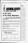
Show June 30, 1969 Page 3 OIL & MINING JOURNAL This 1946 aerial photograph of a portion of Salt Lake County shows wide open areas. East is toward top of photo, north to left. Scale is 1,320 feet to one inch. Aerial shot on right, taken in 1965 shows how Interstate Highway System has changed the look of Salt Lake Valley. Note tremendous growth during the interval ' Aerial maps offer accurate guide If you're rockhound preparing a summer outing, or a geologist pros- - peering for oil, or an attorney settling a land a an dispute, agricultural department aerial photo-ma- p may he just your dish. Such maps are available, at printing cost, from the LIS of Agriculture Department Photo Laboratory, 2505 Parleys Way, Salt Lake Gty, Utah. The aerial photo-map- The photos are made on four s, covering 80 per cent of the U.S. land area, are produced government use, but once made they become a natural resource for sale to the public, Comer Smith, laboratory chief, said. About 20,000 of the maps are sold yearly, he said. We didnt ask what the maps are used for, Mr. Smith said, but he noted that customers include land assessors, real estate developers, highway planners, geologists and students. for scales ranging one inch to 1,667 feet to one inch to 400 feet. The USDA began making the maps in 1933 as the most accurate and cheapest way to administer such laws as the farm support program. Mr. Smith said the maps are 99 per cent accurate-ev- en better in most cases than traditional plane table and surveyors chain Aerial photos are taken by contract pilots who must meet high government standards. They fly at 13,000 feet above average surface level taking pictures of eight square miles at a time. Engineers correct inaccuracies in the photos, adjusting them to methods of determining land points on the pictures that are determined by careful ground areas. And, he said, the maps caost surveys. The maps are then only peanuts compared to printed on computerized photo older methods of surveying. Cost equipment at the USDA lab. show of making the maps is estimated Sequential photo-map- s how both man and at $2.18 per square mile. exactly nature have changed the land surface over the years. They show houses, roads, scrubs, land erosion, fence lines and crop boundaries. Mr. Smith said the negative files are of considerable historical value. He noted that most of the aerial photos made of the western United States are on file at the Salt Lake Gty office, but some of the earliest are available only through the National Archives in Washington, D.C. Letter notes Pennell changes Shareholders of Pennell urged to Uranium, Inc., are exchange their stock certificates for shares of the newly-forme- d Strategic Oils, Inc. in a letter by Dr. Edmund Svastits, Sherman Oaks, California, newly elected president of the company. Dr. Svastits said the corporation name change came HOW'S THE MARKET? Dont ever ask Utah State Manager Frank Morgan that. . .how the market is. Chances are he doesnt know. Because the truth is he doesn't care. Why should I?" he says. Let stock brokers and their customers worry about market ups and downs. Tm selling lifetime investments. If someone buys funds from me today, I expect him not to look at the price till 1979. Funds need time. And which fund does Morgan recommend? There are 800 funds, he replies. What I recommend depends on what an investors objective is. There never was was a time in the fund industry when advise-givin- g as much of an art as today. Frank Morgan State Manager S. L Phone 328-989- 1 Lind, Inc., Mutual Funds ISO So. 6th East, Ambassador Plain, S.LC Ml 02, Svito 10C about at a March stockholders meeting in which of the recapitalization corporation was authorized from 10 million shares at $.01 par value to 10 million shares at $.10 par value. He said this means the shares will be exchanged at a rate of 10 shares of Pennell for one share of Strategic Oils. The meeting also authorized the acquisition of the assets subject to the liabilities of Tahoneroas, Ltd. for five million shares of Strategic Oils Common Stock and elected a new board of directors, Dr. Svastits said. Oils a Utah corporation, and Utah Registrar & Transfer Co., 1243 E. 2100 South, Salt Lake Gty, is transfer agent, Dr. Svastits said. He said exchange of shares and issuance of new certificates will be accomplished by Utah Registrar & Transfer. He said an unfortunate confusion exists among some shareholders as a result of the name change and recapitalization which his letter was designed to clear up. Strategic is Hickel hears oil shale problems WASHINGTON-lnteri- or Secretary Walter J. Hickel met with members of Congress and representatives of oil shale states last week to discuss the direction of oil shale development. The session was mostly an airing of problems, with no decisions. Several participants expressed dissatisfaction with prevailing signs. There is a question whether the Interior Department will show the courage to go ahead with oil' shale leasing, or in the way of development of oil shale into problems economic production. procrastinate, Colorado Gov. John Love complained Rep. John Wold, He added that he saw no attended the meeting, with a sign from Hickel that this delegation. When the meeting concluded, situation would change greatly. Hickel sat at a briefing table Hickel told newsmen, I think in his conference room and the most important thing to talked for several hours with the come out of this meeting was for visitors. Sen. Gordon Allott, the senators and governors to had arranged the point out the problems that session to explore some of the exist. continue o. o., to |